| During the month of April, Mark Miller will donate $75 to the charity of your choice (5 to chose from, including the Utah Avalanche Center!) Mark Miller Subaru has raised over $300k in the previous 6 Do Good Feel Good events. More Info here |  |
| During the month of April, Mark Miller will donate $75 to the charity of your choice (5 to chose from, including the Utah Avalanche Center!) Mark Miller Subaru has raised over $300k in the previous 6 Do Good Feel Good events. More Info here | |
| Advisory: Ogden Area Mountains | Issued by Drew Hardesty for Wednesday - December 11, 2013 - 7:23am |
|---|

|
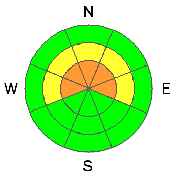
bottom line Areas of CONSIDERABLE AVALANCHE DANGER remain on west through north through east facing slopes above 8000 feet on slopes approaching 35 degrees and steeper. A MODERATE danger exists in the 7-8000 foot range along these same aspects. Remotely triggered avalanches (slides triggered at a distance) remain a distinct possibility. Collapsing and cracking are key signs of instability.
|
 |
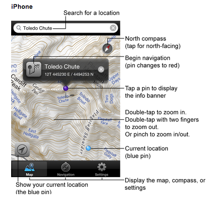
special announcement Brett Kobernik will be hosting a Fireside Avalanche Chat at Black Diamond this Thursday, 7:30pm. He will discuss the formation of our early season weak layers, speculate on future persistent weak layer trends and talk about how to manage the situation in the backcountry. UAC staff Trent Meisenheimer and Craig Gordon continue to push the envelope with an excellent short video clip, "Knowledge is PowDer" - Can't live without your mobile device? Check these apps out from the UAC -
|
 |
current conditions Skies are clear. Temperatures continue to warm with overnight lows in the teens up high, the single digits down low. Winds, mercifully, have lost some steam from yesterday's gusts into the 50s and are now a much more civilized 15-20mph from the west. Riding conditions remain quite good in the wind sheltered terrain. Current snow depths range from 2-3' in the Provo, Park City and Ogden mountains to 2-4' in the Cottonwoods. This should be our maximum for the next while as the snowpack rots from the top down and the bottom up under the dome of high pressure. |
 |
recent activity Mountain resort avalanche control work initiated some hard slab avalanches up to 3' deep in the steep open terrain; others traveling the backcountry noted plenty of cracking and collapsing within the old snow and the new wind slabs (10-12" deep). Updated Avalanche Aspect/Elevation Pattern for reported avalanches into old faceted snow since Dec 3rd (info fm SL mountains)
|
| type | aspect/elevation | characteristics |
|---|

|
|
LIKELIHOOD
 LIKELY
UNLIKELY
SIZE
 LARGE
SMALL
TREND
 INCREASING DANGER
SAME
DECREASING DANGER
|
|
description
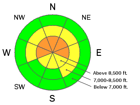
Lack of reports of new avalanches into old faceted snow yesterday offers little to no confidence for the persistent slab problem. Collapsing and cracking still rule the day; moreover these collapses are not isolated 'pops' but rather some deep great propagating guttural moan like something out of a Cormac McCarthy end of days novel. Advice from The Road extends to those who may assume that things are better than they are - “If trouble comes when you least expect it then maybe the thing to do is to always expect it.” Remotely triggered slides with collapses may release above, adjacent to, or below you. Note the activity avalanche rose in blue; avoid this terrain or choose slopes less than 35 degrees with nothing steeper above. Time, friends.
|
| type | aspect/elevation | characteristics |
|---|

|
|
LIKELIHOOD
LIKELY
UNLIKELY
SIZE
 LARGE
SMALL
TREND
 INCREASING DANGER
SAME
DECREASING DANGER
|
|
description
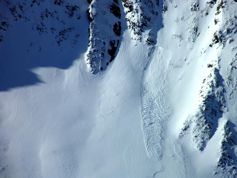
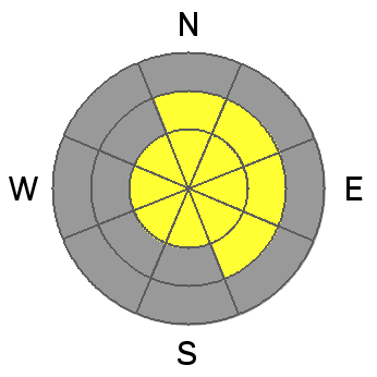
Moderate to strong westerlies dominated the ridgelines with visible plumes, swirling snow devils, and the usual erosion, etching, and drifting noted in the open, exposed terrain. The drifting produced not just a few shallow natural wind pockets to release to say nothing of its impact on skiing and riding conditions. Avoid pillowed lee and crossloaded drifts today and give these another day to settle out (should be another day or so). Mark White photo below of natural pocket along the Cardiac Ridge of Big Cottonwood (northeast at 10,600' or so). Hard wind drifts are way more unpredictable than soft slabs. They may release well above you or on the 4th person across the slope. Avoid the smooth, rounded, often hollow sounding drifts -
|
 |
weather We'll see clear skies, light westerly winds and daytime highs reaching near 20 degrees at 10,000' and near 30 at 8000'. Expect gradual warming through the week with choking smog developing in the valleys. A weak disturbance moves through on Friday that may produce a couple snowflakes and a dip in mountain temps. The ridge rebuilds for the weekend and into next week. |
| general announcements
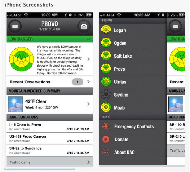
This information does not apply to developed ski areas or highways where avalanche control is normally done. This advisory is from the U.S.D.A. Forest Service, which is solely responsible for its content. This advisory describes general avalanche conditions and local variations always occur. If you trigger an avalanche in the backcountry - especially if you are adjacent to a ski area – please call the following teams to alert them to the slide and whether anyone is missing or not. Rescue teams can be exposed to significant hazard when responding to avalanches, and do not want to do so when unneeded. Thanks. Salt Lake and Park City – Alta Central (801-742-2033), Canyons Resort Dispatch (435-615-3322) Snowbasin Resort Dispatch (801-620-1017), Powder Mountain Dispatch (801-745-3772 x 123). Sundance Dispatch (801-231-4150) Twitter Updates for your mobile phone - DETAILS UDOT canyon closures: LINK TO UDOT Utah Avalanche Center mobile app - Get your advisory on your iPhone along with great navigation and rescue tools. We'll soon be lining up a new automated emailed advisory delivery system - stay tuned. Wasatch Powderbird Guides Blog/Itinerary for the Day. They'll be up and running later this winter - Discount lift tickets are now available at Backcountry.com - Thanks to Ski Utah and the Utah Resorts. All proceeds go towards paying for Utah Avalanche Center avalanche and mountain weather advisories. To those skinning uphill at resorts: it is your responsibility to know the resort policy on uphill travel. Some allow uphill travel and have guidelines, some don't. Contact the Ski Patrol at each resort for details. IMPORTANT: Before skinning at a resort under new snow conditions, check in with Ski Patrol. Resorts can restrict or cut off access if incompatible with control and grooming operations. Benefit the Utah Avalanche Center when you shop from Backcountry.com or REI: Click this link for Backcountry.com or this link to REI, shop, and they will donate a percent of your purchase price to the UAC. Both offer free shipping (with some conditions) so this costs you nothing! Benefit the Utah Avalanche Center when you buy or sell on ebay - set the Utah Avalanche Center as a favorite non-profit in your ebay account here and click on ebay gives when you buy or sell. You can choose to have your seller fees donated to the UAC, which doesn't cost you a penny. Remember your information can save lives. If you see anything we should know about, please participate in the creation of our own community avalanche advisory by submitting snow and avalanche conditions. You can also call us at 801-524-5304 or 800-662-4140, email by clicking HERE, or include #utavy in your tweet or Instagram. |


_4.jpg)