| During the month of April, Mark Miller will donate $75 to the charity of your choice (5 to chose from, including the Utah Avalanche Center!) Mark Miller Subaru has raised over $300k in the previous 6 Do Good Feel Good events. More Info here |  |
| During the month of April, Mark Miller will donate $75 to the charity of your choice (5 to chose from, including the Utah Avalanche Center!) Mark Miller Subaru has raised over $300k in the previous 6 Do Good Feel Good events. More Info here | |
| Advisory: Ogden Area Mountains | Issued by Drew Hardesty for Tuesday - December 10, 2013 - 7:28am |
|---|

|
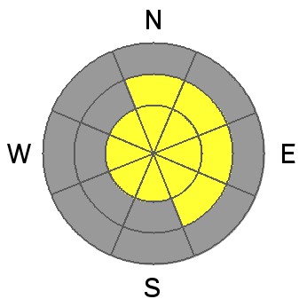
bottom line Localized areas of CONSIDERABLE avalanche danger remains on west through north through east facing slopes above 8000 feet on slopes approaching 35 degrees and steeper. Human triggered avalanches avalanches breaking 2' deep are likely. A MODERATE danger exists below the 8000' foot range along these same aspects were human triggered slides are less pronounced but still possible. Remotely triggered avalanches (triggered at a distance) also remain a distinct possibility. Collapsing and cracking are key signs of instability. Best to avoid these slopes until they heal...
|
 |
special announcement Brett Kobernik will be hosting a Fireside Avalanche Chat at Black Diamond this Thursday, 7:30pm. He will discuss the formation of our early season weak layers, speculate on future persistent weak layer trends and talk about how to manage the situation in the backcountry. UAC staff Trent Meisenheimer and Craig Gordon continue to push the envelope with an excellent short video clip, "Knowledge is PowDer" - James Roh, a journalist for the Daily Herald, has an excellent article about avalanches in the Provo moutains here - |
 |
current conditions Skies are clear. Under a building ridge of high pressure, temperatures aloft have bounced back to - well - just above zero (mostly in the single digits to low teens). The west to northwest winds remain moderate to strong from the west, but they should lose some steam throughout the day. Riding conditions are excellent on all aspects, though take note to avoid the isolated wind damage in the exposed terrain above treeline from the gusty southerly winds over the weekend. With an inversion setting in, the mountains will be place to be, where the experience and powder snow will border on the sublime. In the meantime, high RH, light wind and cold temps will cap the "drying out" snow surfaces with flakes of surface hoar. Enjoy -
|
 |
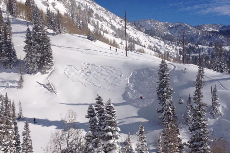
recent activity With the popularity of social media and 24 hour real-time news reporting, most of you by now have probably heard about the full depth burial and live recovery in the infamous Grizzly Gulch terrain trap in the Alta periphery. Did I mention social media? The entire event was caught on video - and a job well done to the folks who filmed the avalanche and then skied down to conduct the full rescue and recovery. This makes the 4th full burial and live recovery in the past two seasons. It's difficult to overstate the importance of being prepared with all the right rescue gear and the practice of knowing how to conduct a safe and efficient rescue. Well done! Brett Kobernik will be heading up the investigation today; refer back to the link above (or our Avalanche List in the menu at the top of the page) to see more information later tonight. (photo below of the woman caught in the slide in Grizzly Gulch by one of the rescuers Aaron Rice).
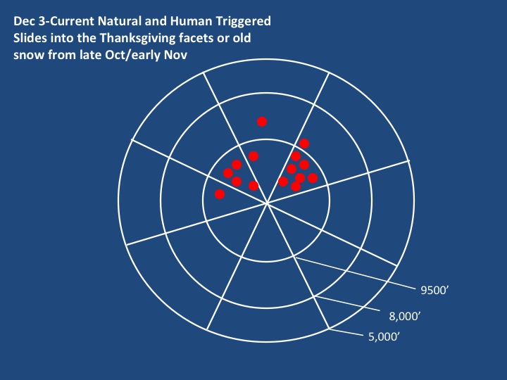
I've put together visual below of slides into the older faceted snow since Dec 3rd for the Salt Lake mountains - these are all "backcountry" avalanches and do not include the extensive and deep avalanches triggered by avalanche teams at the SLC resorts yesterday...
|
| type | aspect/elevation | characteristics |
|---|

|
|
LIKELIHOOD
 LIKELY
UNLIKELY
SIZE
 LARGE
SMALL
TREND
 INCREASING DANGER
SAME
DECREASING DANGER
|
|
description
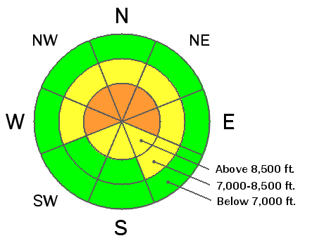
These persistent slabs are most pronounced on west to north to east facing slopes above about 7500' and breaking up to 2'+ deep and a couple hundred feet wide. Collapsing has been the rule and not the exception - a Public Service Announcement - that the overlying slab and your weight was enough to collapse the underlying older weak faceted snow from 1 - early Nov and/or 2 - time frame around Thanksgiving. Remotely triggered slides remain a distinct possibility; avoiding this terrain for now is key for longevity; or choose slopes less than 35 degrees with nothing steeper above.
|
| type | aspect/elevation | characteristics |
|---|

|
|
LIKELIHOOD
LIKELY
UNLIKELY
SIZE
 LARGE
SMALL
TREND
INCREASING DANGER
SAME
DECREASING DANGER
|
|
description
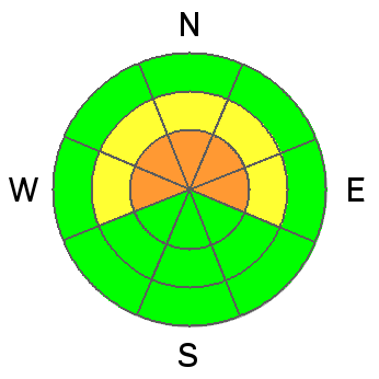
Westerly winds predominantly load east facing slopes but it seems wind slabs form on all aspects due to local variations in wind direction as well as cross loading. The wind slabs can fail within the most recent snow layering as well as enhancing the chance of something breaking into faceted snow - step-downs, as these are called are significantly more hazardous, entraining quite a bit more snow. |
 |
weather We'll see clear skies, moderate westerly winds and daytime highs reaching into the mid-teens at 10,000' and near 20 at 8000'. Expect gradual warming through the week with choking smog developing in the valleys. A weak disturbance moves through on Friday. |
| general announcements
This information does not apply to developed ski areas or highways where avalanche control is normally done. This advisory is from the U.S.D.A. Forest Service, which is solely responsible for its content. This advisory describes general avalanche conditions and local variations always occur. If you trigger an avalanche in the backcountry - especially if you are adjacent to a ski area – please call the following teams to alert them to the slide and whether anyone is missing or not. Rescue teams can be exposed to significant hazard when responding to avalanches, and do not want to do so when unneeded. Thanks. Salt Lake and Park City – Alta Central (801-742-2033), Canyons Resort Dispatch (435-615-3322) Twitter Updates for your mobile phone - DETAILS UDOT canyon closures: LINK TO UDOT Utah Avalanche Center mobile app - Get your advisory on your iPhone along with great navigation and rescue tools. We'll soon be lining up a new automated emailed advisory delivery system - stay tuned. Wasatch Powderbird Guides Blog/Itinerary for the Day. They'll be up and running later this winter - Discount lift tickets are now available at Backcountry.com - Thanks to Ski Utah and the Utah Resorts. All proceeds go towards paying for Utah Avalanche Center avalanche and mountain weather advisories. To those skinning uphill at resorts: it is your responsibility to know the resort policy on uphill travel. Some allow uphill travel and have guidelines, some don't. Contact the Ski Patrol at each resort for details. IMPORTANT: Before skinning at a resort under new snow conditions, check in with Ski Patrol. Resorts can restrict or cut off access if incompatible with control and grooming operations. Benefit the Utah Avalanche Center when you shop from Backcountry.com or REI: Click this link for Backcountry.com or this link to REI, shop, and they will donate a percent of your purchase price to the UAC. Both offer free shipping (with some conditions) so this costs you nothing! Benefit the Utah Avalanche Center when you buy or sell on ebay - set the Utah Avalanche Center as a favorite non-profit in your ebay account here and click on ebay gives when you buy or sell. You can choose to have your seller fees donated to the UAC, which doesn't cost you a penny. Remember your information can save lives. If you see anything we should know about, please participate in the creation of our own community avalanche advisory by submitting snow and avalanche conditions. You can also call us at 801-524-5304 or 800-662-4140, email by clicking HERE, or include #utavy in your tweet or Instagram. |


_4.jpg)