| During the month of April, Mark Miller will donate $75 to the charity of your choice (5 to chose from, including the Utah Avalanche Center!) Mark Miller Subaru has raised over $300k in the previous 6 Do Good Feel Good events. More Info here |  |
| During the month of April, Mark Miller will donate $75 to the charity of your choice (5 to chose from, including the Utah Avalanche Center!) Mark Miller Subaru has raised over $300k in the previous 6 Do Good Feel Good events. More Info here | |
| Advisory: Ogden Area Mountains | Issued by Evelyn Lees for Sunday - December 8, 2013 - 7:10am |
|---|


|
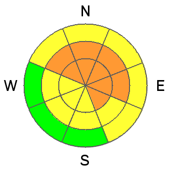
bottom line The avalanche danger remains CONSIDERABLE on all northwest, north and northeasterly facing slopes, steeper than about 33 degrees, where deep, dangerous avalanches can be triggered in mid and upper elevation terrain. Slides can be triggered from a distance, so avoid travel below and adjacent to steep slopes. Also avoid all steep wind drifted slopes. CONSIDERABLE means:
Recreate on lower angle slopes today, in wind sheltered terrain, and consider options on the southerly ½ of the compass.
|
 |
current conditions Storm totals of low density, cold powder –
Temperatures have once again plummeting into negative territory, and are in the single digits above and below zero. The westerly winds are generally light, averaging less the 10 mph, with only the highest ridgelines in the 20 to 25 mph range, with gusts to 40. |
 |
recent activity
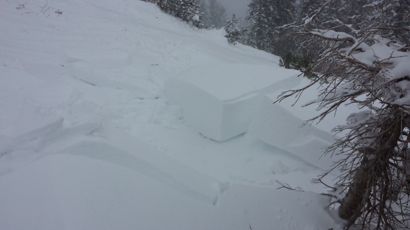
Remotely triggered Raymond wind slab
|
| type | aspect/elevation | characteristics |
|---|

|

|
LIKELIHOOD
 LIKELY
UNLIKELY
SIZE
 LARGE
SMALL
TREND
 INCREASING DANGER
SAME
DECREASING DANGER
|
|
description
In my mind, there is still a skull and cross bone on the northwest, north and northeasterly facing slopes at the mid and upper elevations, where layers of weak, faceted snow crystals are buried in the snow pack. While I hope that at least some of these slopes avalanched naturally during the wind event, I expect the snow on most slopes is left hanging in balance, just waiting for a trigger. A trigger today could be a person or a smaller new snow slide that then steps down, triggering a deeper, wider slide. These deeper, dangerous slides can be triggered remotely, from below, the side or above, and have the potential to break out widely. |
| type | aspect/elevation | characteristics |
|---|

|
|
LIKELIHOOD
LIKELY
UNLIKELY
SIZE
 LARGE
SMALL
TREND
INCREASING DANGER
SAME
DECREASING DANGER
|
|
description
Yesterday’s widespread wind drifts will be more stubborn today, but still want to crack out beneath you, and are large enough to take a person for a ride, and in places bury them. The drifts are now hidden beneath the overnight snow, and will be harder to identify. The drifts are most widespread along the high ridgelines on northerly through easterly facing slopes, but were also found yesterday out in open bowls. |
 |
weather The storm is winding down, with light snow showers this morning perhaps adding another inch or two of snow to the totals. Temperatures will remain near zero at 8,000’ feet and negative 5 to 10 degrees at 10,000’. The westerly winds will generally remain less than 15 mph, except for the high peaks and ridge lines, with 20 to 25 mph averages and gusts to 40 mph. In the long range, high pressure with a stable northwest flow will be over the area through at least mid-week. |
| general announcements This information does not apply to developed ski areas or highways where avalanche control is normally done. This advisory is from the U.S.D.A. Forest Service, which is solely responsible for its content. This advisory describes general avalanche conditions and local variations always occur. If you trigger an avalanche in the backcountry - especially if you are adjacent to a ski area – please call the following teams to alert them to the slide and whether anyone is missing or not. Rescue teams can be exposed to significant hazard when responding to avalanches, and do not want to do so when unneeded. Thanks. Salt Lake and Park City – Alta Central (801-742-2033), Canyons Resort Dispatch (435-615-3322) Twitter Updates for your mobile phone - DETAILS UDOT canyon closures: LINK TO UDOT Utah Avalanche Center mobile app - Get your advisory on your iPhone along with great navigation and rescue tools. We'll soon be lining up a new automated emailed advisory delivery system - stay tuned. Wasatch Powderbird Guides Blog/Itinerary for the Day. They'll be up and running later this winter - Discount lift tickets are now available at Backcountry.com - Thanks to Ski Utah and the Utah Resorts. All proceeds go towards paying for Utah Avalanche Center avalanche and mountain weather advisories. To those skinning uphill at resorts: it is your responsibility to know the resort policy on uphill travel. Some allow uphill travel and have guidelines, some don't. Contact the Ski Patrol at each resort for details. IMPORTANT: Before skinning at a resort under new snow conditions, check in with Ski Patrol. Resorts can restrict or cut off access if incompatible with control and grooming operations. Benefit the Utah Avalanche Center when you shop from Backcountry.com or REI: Click this link for Backcountry.com or this link to REI, shop, and they will donate a percent of your purchase price to the UAC. Both offer free shipping (with some conditions) so this costs you nothing! Benefit the Utah Avalanche Center when you buy or sell on ebay - set the Utah Avalanche Center as a favorite non-profit in your ebay account here and click on ebay gives when you buy or sell. You can choose to have your seller fees donated to the UAC, which doesn't cost you a penny. Remember your information can save lives. If you see anything we should know about, please participate in the creation of our own community avalanche advisory by submitting snow and avalanche conditions. You can also call us at 801-524-5304 or 800-662-4140, email by clicking HERE, or include #utavy in your tweet or Instagram. |


_4.jpg)