
| During the month of April, Mark Miller will donate $75 to the charity of your choice (5 to chose from, including the Utah Avalanche Center!) Mark Miller Subaru has raised over $300k in the previous 6 Do Good Feel Good events. More Info here |  |
| During the month of April, Mark Miller will donate $75 to the charity of your choice (5 to chose from, including the Utah Avalanche Center!) Mark Miller Subaru has raised over $300k in the previous 6 Do Good Feel Good events. More Info here | |
| Advisory: Ogden Area Mountains | Issued by Evelyn Lees for Wednesday - November 27, 2013 - 6:47am |
|---|

|
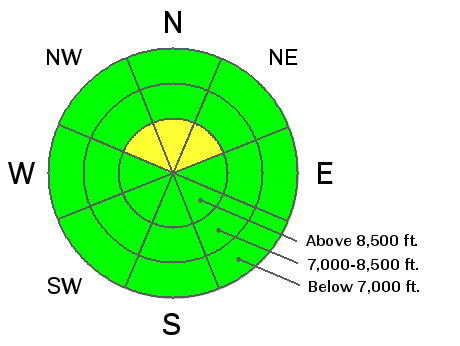
bottom line There is a mostly LOW avalanche danger, with pockets of MODERATE avalanche danger on steep, northwest, north and northeasterly facing slopes where there is wind drifted snow over facets. In isolated places at the upper elevations, a person could trigger a slide, and any ride would be rocky and rough. This avalanche advisory will cover both today and Thursday with our next advisory Friday morning.
|
 |
special announcement UDOT artillery sight-in: Big Cottonwood Canyon this morning, 11/27/13, @ 8:30 am. South side of canyon is CLOSED from Broads Fork thru Stairs Gulch until 9:30 am. Do your homework before your Black Friday shopping spree – updated info is now available on beaconreviews.com. Also check out the links at the bottom of the page, with no cost to you, you can benefit the UAC when you shop on line at backcountry.com, REI and Ebay. A couple top tier restaurants will be running specials next week to benefit the Utah Avalanche Center - Grab a Bite and Support the UAC - Thanks
|
 |
current conditions Another beautiful day in the mountains – mostly clear skies, with temperatures right around freezing this morning. The southwesterly winds are light, averaging less than 10 mph, at just about every mountain weather station but those in Ogden area mountains, where speeds across the high ridges are averaging closer to 20 mph. The snowpack remains very shallow, with few options for easy backcountry travel. Even some of the early season “classic” places to go are rock studded, and the lower elevations and sunny slopes are melting down to dirt. Still, there are a few nice pockets of soft snow on upper elevation, shady slopes, and the groomers at the resorts are an excellent choice for early season turns and clean air. |
 |
recent activity The most recent reported avalanche activity was from Monday - resort avalanche reduction work in Little Cottonwood triggered several medium sized hard slab avalanches on wind loaded northeasterly facing slopes, failing on facets. Looking at the Avalanche List, there have been no reported backcountry avalanches since November 17th in the Wasatch mountains. |
| type | aspect/elevation | characteristics |
|---|

|
|
LIKELIHOOD
 LIKELY
UNLIKELY
SIZE
 LARGE
SMALL
TREND
 INCREASING DANGER
SAME
DECREASING DANGER
|
|
description
Wind slabs over facets remain the main concern. There are spotty places where a person could trigger one of these dense or hard wind drifts, mostly on northwest, north or northeasterly facing slopes. These drifts could be right along the ridgelines or mid slopes, and avoid the hard drifts on any steep slope. My field work yesterday showed an overall weakening snowpack – and the shallower the snowpack, the weaker. If you’re out and about, look for the pattern of sugary loose snow - on the surface, beneath the wind crusts and wind board, near the ground and in shallow snowpack areas…the whole snowpack. |
 |
weather The quiet weather week continues… A slight shift in the ridge axis will allow a few high thin clouds to move overhead today and a very light southerly flow to develop. High temperatures will be in the mid-30s to mid- 40s today, and then drop to near freezing again tonight. Partly cloudy skies and mild temperatures will continue into Sunday, with a few snow flurries possible Saturday evening. Then there is hope on the horizon for a return to winter, with a strong cold front in the forecast for Monday night. |
| general announcements If you trigger an avalanche in the backcountry - especially if you are adjacent to a ski area – please call the following teams to alert them to the slide and whether anyone is missing or not. Rescue teams can be exposed to significant hazard when responding to avalanches, and do not want to do so when unneeded. Thanks. Salt Lake and Park City – Alta Central (801-742-2033), Canyons Resort Dispatch (435-615-3322) Twitter Updates for your mobile phone - DETAILS UDOT canyon closures UDOT at (801) 975-4838 Get your advisory on your iPhone with the Utah Avalanche Center mobile app, along with great navigation and rescue tools. Wasatch Powderbird Guides Blog/Itinerary for the Day. They'll be up and running later this winter - Benefit the Utah Avalanche Center when you shop from Backcountry.com or REI: Click this link for Backcountry.com or this link to REI, shop, and they will donate a percent of your purchase price to the UAC. Both offer free shipping (with some conditions) so this costs you nothing! Benefit the Utah Avalanche Center when you buy or sell on ebay - set the Utah Avalanche Center as a favorite non-profit in your ebay account here and click on ebay gives when you buy or sell. You can choose to have your seller fees donated to the UAC, which doesn't cost you a penny. Remember your information can save lives. If you see anything we should know about, please participate in the creation of our own community avalanche advisory by submitting snow and avalanche conditions. You can also call us at 801-524-5304 or 800-662-4140, email by clicking HERE, or include #utavy in your tweet or Instagram. |


_4.jpg)