| During the month of April, Mark Miller will donate $75 to the charity of your choice (5 to chose from, including the Utah Avalanche Center!) Mark Miller Subaru has raised over $300k in the previous 6 Do Good Feel Good events. More Info here |  |
| During the month of April, Mark Miller will donate $75 to the charity of your choice (5 to chose from, including the Utah Avalanche Center!) Mark Miller Subaru has raised over $300k in the previous 6 Do Good Feel Good events. More Info here | |
| Advisory: Ogden Area Mountains | Issued by Evelyn Lees for Saturday - November 23, 2013 - 7:43am |
|---|


|
bottom line While the overall avalanche danger is MODERATE, there are POCKETS of CONSIDERABLE avalanche danger where drifts of wind blown snow over lie weak facets near the ground - mostly on upper elevation northwest, north and northeasterly facing slopes. Avoid any steep slope with recent drifts of wind blown snow, especially avoid travel in the wind blasted, upper elevation terrain on northerly facing slopes.
|
 |
current conditions Unexpectedly, wind speeds increased overnight in the Ogden and Salt Lake mountains. 10,000’ speeds picked it up into the 20 to 35 mph range, gusts 40s and 50s. High peaks are or had averages overnight in the 40 to 60 mph range, with gusts into the 70s. Temperatures are in the teens along the high ridges, and the 20s elsewhere and the winds will make it feel like the single digits along the exposed ridge lines. Out of the wind zone, yesterday there was still nice soft snow on very sheltered shady slopes. The snow surface is a bit of a disaster and best avoided on the upper elevation, wind hammered and drifted slopes - hard slab, breakable slab or eroded to the ground. |
 |
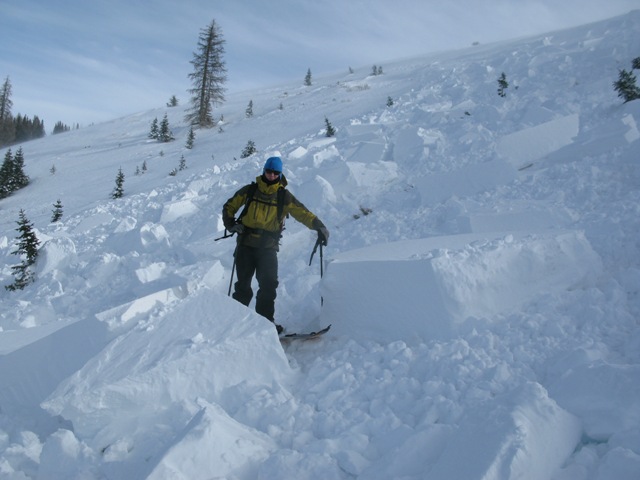
recent activity Resort avalanche reduction work produced small to medium avalanches with explosives and ski testing on the upper elevation, wind drifted, northerly facing slopes in the Cottonwoods. One small natural was also noted, and most of these were failing on the facets near the ground. Cracking and collapsing reported from both the Park City side and Ogden area mountains. Temperatures are in the teens along the high ridges, and the 20s elsewhere and the winds will make it feel like the single digits along the exposed ridge lines.
Collapse with crack jetting out of the snowpit to viewer's right. This at 8800' northerly wind loaded terrain. |
| type | aspect/elevation | characteristics |
|---|

|
|
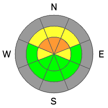
LIKELIHOOD
 LIKELY
UNLIKELY
SIZE
 LARGE
SMALL
TREND
 INCREASING DANGER
SAME
DECREASING DANGER
|
|
description
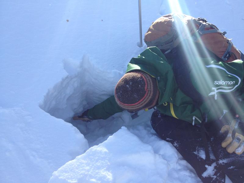
Field work and yesterday's avalanches failing near the ground show that with an additional snow load - in this case drifts of wind blown snow - the loose, sugary depth hoar near the ground is just waiting for a trigger, and can fail with the added weight of a person. With hard slab drifts on facets, avalanches can be stubborn, and break out above you, and be triggered from a distance and from below. Photo - Brian Pollick pointing down to the weak faceted snow 16" down.
Steep slopes where the two combine - new wind drifts over depth hoar - will be the most dangerous today, the most likely place to trigger a slide today, and should be avoided. This combo will be most common on northerly facing slopes, above about 9,000'.
|
| type | aspect/elevation | characteristics |
|---|

|
|
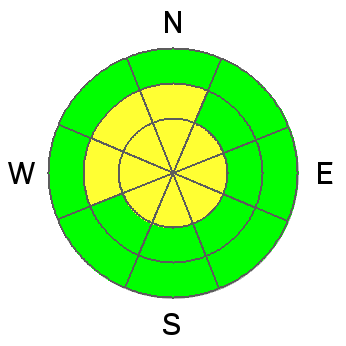
LIKELIHOOD
LIKELY
UNLIKELY
SIZE
 LARGE
SMALL
TREND
INCREASING DANGER
SAME
DECREASING DANGER
|
|
description
The moderate to strong southeasterly winds have eroded snow and deposited it both along the high ridge lines and into drifts in some of the mid elevation terrain. Terrain channels the wind in strange ways, so while the southeast winds put most of the drifts on northerly and westerly facing slopes, there could be isolated drifts on other aspects, too, especially along the high ridge lines and in open, upper elevation bowls, including well off the ridge lines. Avoid any steep slope with recent wind drifts. Most of these drifts are cracky hard slabs - they will feel solid and supportable underfoot, but can still break and avalanche on steep slopes. So what's a hard slab? Check outCraig's Uinta observation from yesterday - dense, tightly packed wind blown snow that's hard and stays in chunks after it avalanches.
|
 |
weather The slow motion low pressure to our south will keep moderate to strong, southeasterly winds blowing through tonight. There is uncertainty as to when the winds will start decrease, but hopefully by noon. In the meantime, 20 to 30 mph averages along the high ridgelines, with gusts to 50 will be common, with higher speed possible. Temperatures will continue to warm, into the mid-30s at 8,000’, and mid-20s at 10,000’. Cloud cover will increase, and there is a slight chance for snow later today and tonight - a trace to an inch or two. Then high and dry into early next week. |
| general announcements If you trigger an avalanche in the backcountry - especially if you are adjacent to a ski area – please call the following teams to alert them to the slide and whether anyone is missing or not. Rescue teams can be exposed to significant hazard when responding to avalanches, and do not want to do so when unneeded. Thanks. Salt Lake and Park City – Alta Central (801-742-2033), Canyons Resort Dispatch (435-615-3322) Twitter Updates for your mobile phone - DETAILS UDOT canyon closures UDOT at (801) 975-4838 Get your advisory on your iPhone with the Utah Avalanche Center mobile app, along with great navigation and rescue tools. Remember your information can save lives. If you see anything we should know about, please participate in the creation of our own community avalanche advisory by submitting snow and avalanche conditions. You can also call us at 801-524-5304 or 800-662-4140, email by clicking HERE, or include #utavy in your tweet or Instagram. |


_4.jpg)