

Avalanche Advisory
| Advisory: Ogden Area Mountains | Issued by Evelyn Lees for March 19, 2013 - 6:50am |
|---|


Above 8,500 ft.
7,000-8,500 ft.
Below 7,000 ft.
|
bottom line The avalanche danger is generally LOW. However, small avalanches are possible on steep slopes, and in isolated areas or extreme terrain even a small slide can have serious consequences. People could trigger shallow winds drifts along the highest ridgelines, a cornice, or damp sluffs as the day heats up. Steep icy slopes are dangerous.
|

 |
special announcement
|
 |
current conditions Under mostly clear skies, there is a wintery feel again this morning, with temperatures in the 20s. The northwesterly winds are in the 10 to 20 mph range, and gusts have decreased into the 20s. Sunday night’s disturbance managed to produce 2 to 6” of snow in the upper elevations of the Park City, Salt Lake, Logan area mountains and around the Monte Cristo area. Generally though, hard and icy snow surfaces are widespread, and less than ideal for sledding, snowshoeing and turning until they soften later today. |
 |
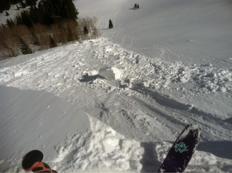
recent activity Only minor avalanche activity was reported yesterday, including a few small soft wind drifts, human triggered dry and damp sluffs where there was new snow, and an unintentional cornice drop on Reynolds peak in Big Cottonwood – photo below.
|
Avalanche Problem 1over the next 24 hours
| type | aspect/elevation | characteristics |
|---|
 |
Above 8,500 ft.
7,000-8,500 ft.
Below 7,000 ft.
|
|
|
description
Even with a LOW avalanche danger, there are a few places where a person could trigger a small slide. In extreme terrain or on very steep slopes, there could be serious consequences if you go for a fast icy ride, are pushed off a cliff or into trees. Watch out for:
|

 |
weather Skies will be clear to partly cloudy today as a brief ridge of high pressure moves over northern Utah. Temperatures will warm to near 40 at 8000’ and remain in the low to mid 20s along the high ridges. The northwesterly winds will continue to slowly decrease throughout the day. A pair of storm systems will reach northern Utah starting tomorrow. Clouds and southwesterly winds will increase this evening ahead of Wednesday’s warm storm. Snow and rain showers on Wednesday, with a rain /snow line near 8,000’. A second, much colder storm will move in later Wednesday night, with 6 to 12” of snow possible above 9,000’ on Thursday. Additional light snow is possible on Friday. |
| general annoucements Go to http://www.backcountry.com/utah-avalanche-center to get tickets from our partners at Beaver Mountain, Canyons, Sundance, and Wolf Mountain. All proceeds benefit the Utah Avalanche Center. If you trigger an avalanche in the backcountry - especially if you are adjacent to a ski area – please call the following teams to alert them to the slide and whether anyone is missing or not. Rescue teams can be exposed to significant hazard when responding to avalanches, and do not want to do so when unneeded. Thanks. Salt Lake and Park City – Alta Central (801-742-2033), Canyons Resort Dispatch (435-615-3322) Ogden – Snowbasin Patrol Dispatch (801-620-1017) Powder Mountain Ski Patrol Dispatch (801-745-3772 ex 123) Provo – Sundance Patrol Dispatch (801-223-4150) Dawn Patrol Forecast Hotline, updated by 05:30: 888-999-4019 option 8. Twitter Updates for your mobile phone - DETAILS Daily observations are frequently posted by 10 pm each evening. Subscribe to the daily avalanche advisory e-mail click HERE. UDOT canyon closures UDOT at (801) 975-4838Wasatch Powderbird Guides does daily updates about where they'll be operating on this bloghttp://powderbird.blogspot.com/ .Remember your information can save lives. If you see anything we should know about, please participate in the creation of our own community avalanche advisory by submitting snow and avalanche conditions. You can also call us at 801-524-5304 or 800-662-4140, email by clicking HERE, or include #utavy in your tweet. Donate to your favorite non-profit –The Friends of the Utah Avalanche Center. The UAC depends on contributions from users like you to support our work. For a print version of this advisory click HERE. This advisory is produced by the U.S. Forest Service, which is solely responsible for its content. It describes only general avalanche conditions and local variations always exist. Specific terrain and route finding decisions should always be based on skills learned in a field-based avalanche class |