

Avalanche Advisory
| Advisory: Ogden Area Mountains | Issued by Evelyn Lees for February 20, 2013 - 6:53am |
|---|


Above 8,500 ft.
7,000-8,500 ft.
Below 7,000 ft.
|
bottom line Avoid steep, wind drifted slopes - the avalanche danger is MODERATE for triggering a wind drift or wind slab on mid and upper elevation slopes facing northwest through northeast. The avalanche danger of new snow slides could increase later tonight and tomorrow in areas that receive 10 or more inches of new snow.
|

 |
special announcement Plan ahead for spring break, guests or deep powder days - there are still a few ski passes left for at Beaver Mountain, Canyons, Sundance, and Wolf Mountain that have been donated by our great partners. All proceeds benefit the Utah Avalanche Center. Go to http://www.backcountry.com/utah-avalanche-center to get tickets. |
 |
current conditions Skies are mostly cloudy in the mountains this morning, and I am just waiting for it to snow…exactly like a couple 100,000 other people from hydrologists and riders to snowmobilers and snowshoers. Soft settled powder is a rare commodity – only to be found on wind and sun sheltered northerly facing slopes that are untracked. Temperatures in the Ogden area mountains are in the low 20s to near 30 this morning, and the southeasterly winds have calmed down from yesterday’s blustery speeds and gusts in the 50s – currently almost every station is averaging less than 15 mph, with only a few gusting into the 20s. |
 |
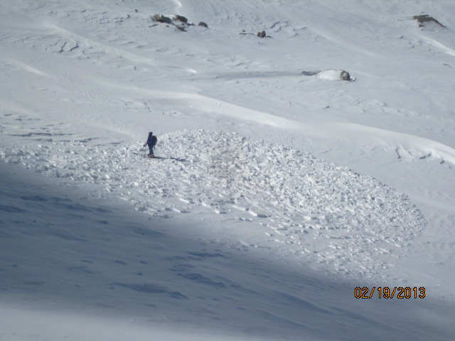
recent activity No new avalanches were reported from the Ogden area mountains yesterday. In the Salt Lake mountains, there were both natural and human triggered wind slab avalanches yesterday. In the backcountry, a person jumping on test slopes in Red Pine released a soft slab on a northwest facing slope, 18” deep by 70’ wide. A party dropping into Hogum triggered two slides – the largest on a west facing slope at 9,500’, which carried the person down slope, very shallow but a 100’ wide. Little Cottonwood resorts reported 2 natural avalanches on northwesterly facing slopes in unskied terrain, one a class 2.
|
Avalanche Problem 1over the next 24 hours
| type | aspect/elevation | characteristics |
|---|
 |
Above 8,500 ft.
7,000-8,500 ft.
Below 7,000 ft.
|
|
|
description
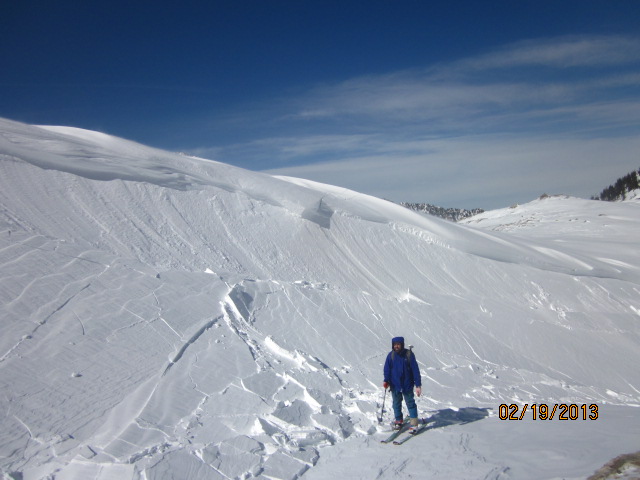
The older, mostly hard drifts of wind-blown snow, created by yesterday’s stronger southerly winds, will continue to be the main issue today. You will find these drifts on both upper and mid elevation slopes, both along and off ridge lines, and around features like gully walls. These hard wind slabs will have a tendency to break out above you, and they are large enough to catch and carry a person. They will become harder to identify once they are hidden by a few inches of snow later today.
|

Avalanche Problem 2over the next 24 hours
| type | aspect/elevation | characteristics |
|---|
 |
Above 8,500 ft.
7,000-8,500 ft.
Below 7,000 ft.
|
|
|
description
Out of the wind affected terrain, the avalanche danger is mostly LOW, but there are always things to keep in mind.
|

 |
weather The sluggish Pacific storm centered to the south of us will be slow to affect northern Utah. A very light southeasterly flow will continue over northern Utah for most of the day, with a few inches of snow possible today. Temperatures will warm into the low 30s at the lower elevations, and into the low 20s along the higher ridgelines of the Ogden area mountains. Winds speeds will average in the 5 to 15 mph range. An additional 3 to 6” of snow is possible tonight as the flow shifts to the northwest. Luckily, the pattern remains active, and there are several more chances for snow. A few more inches produced by a warm air advection pattern late Thursday into Friday, with a cold and more energetic storm possible for Saturday. |
| general annoucements Go to http://www.backcountry.com/utah-avalanche-center to get tickets from our partners at Park City, Beaver Mountain, Canyons, Sundance, and Wolf Mountain. All proceeds benefit the Utah Avalanche Center. If you trigger an avalanche in the backcountry - especially if you are adjacent to a ski area – please call the following teams to alert them to the slide and whether anyone is missing or not. Rescue teams can be exposed to significant hazard when responding to avalanches, and do not want to do so when unneeded. Thanks. Salt Lake and Park City – Alta Central (801-742-2033), Canyons Resort Dispatch (435-615-3322) Ogden – Snowbasin Patrol Dispatch (801-620-1017) Powder Mountain Ski Patrol Dispatch (801-745-3772 ex 123) Provo – Sundance Patrol Dispatch (801-223-4150) Dawn Patrol Forecast Hotline, updated by 05:30: 888-999-4019 option 8. Twitter Updates for your mobile phone - DETAILS Daily observations are frequently posted by 10 pm each evening. Subscribe to the daily avalanche advisory e-mail click HERE. UDOT canyon closures UDOT at (801) 975-4838 Wasatch Powderbird Guides does daily updates about where they'll be operating on this blog http://powderbird.blogspot.com/ . Remember your information can save lives. If you see anything we should know about, please participate in the creation of our own community avalanche advisory by submitting snow and avalanche conditions. You can also call us at 801-524-5304 or 800-662-4140, or email by clicking HERE Donate to your favorite non-profit –The Friends of the Utah Avalanche Center. The UAC depends on contributions from users like you to support our work. For a print version of this advisory click HERE. This advisory is produced by the U.S. Forest Service, which is solely responsible for its content. It describes only general avalanche conditions and local variations always exist. Specific terrain and route finding decisions should always be based on skills learned in a field-based avalanche class. |