

Avalanche Advisory
| Advisory: Ogden Area Mountains | Issued by Evelyn Lees for February 12, 2013 - 6:41am |
|---|


Above 8,500 ft.
7,000-8,500 ft.
Below 7,000 ft.
|
bottom line The avalanche danger is MODERATE for triggering a new wind drift, which will be most widespread along the higher ridgelines, on southerly facing slopes. The avalanche danger is also MODERATE for triggering loose snow sluffs and for the isolated chance of triggering a 1 to 3 foot deep slab avalanche on a northerly facing slope.
|

 |
special announcement Bruce will be giving his very entertaining Science of Avalanches talk tonight at 7 pm at the Salt Lake City REI, on 3200 East and 3300 South. Pre-registration on line at REI is highly recommended to guarantee a spot. |
 |
current conditions It is a cold morning in the mountains, with clouds rapidly spreading across the northern 1/3 of the state. Temperatures in the Ogden mountains are in the single digits to low teens. In contrast to yesterday’s almost dead calm, the northerly winds have picked up, averaging 10-15 mph along the high ridges, with a few spots gusting in the 25 to 30 mph range. This puts the wind chill well below zero. Turning and riding conditions in untracked terrain continue to be excellent – classic dry powder on a supportable base. |
 |
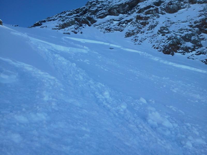
recent activity There was one skier triggered soft slab reported yesterday, on an upper elevation northwesterly facing slope in Broad’s Fork, Big Cottonwood Canyon, triggered by the second person, who was not caught. It was about 100’ wide, probably releasing on the January facet layer. (Photo below) In the Ogden mountains yesterday, there were easily triggered dry sluffs, running far and entraining snow and a few natural dry sluffs.
|
Avalanche Problem 1over the next 24 hours
| type | aspect/elevation | characteristics |
|---|
 |
Above 8,500 ft.
7,000-8,500 ft.
Below 7,000 ft.
|
|
|
description
The increasing winds have plenty of dry, light powder to play with – so expect transport of the snow into soft wind drifts along the ridgelines. These drifts will be most widespread on the southerly facing slopes, and may become just large enough to catch and carry an unaware person. Think where you could be carried, avoiding complex and unforgiving terrain such as gullies or trees. |

Avalanche Problem 2over the next 24 hours
| type | aspect/elevation | characteristics |
|---|
 |
Above 8,500 ft.
7,000-8,500 ft.
Below 7,000 ft.
|
|
|
description
There are a handful of other avalanche issues to keep on your radar as you travel through the backcountry -
|

 |
weather Increasing clouds are the name of the game today, with few snow flurries possible late afternoon. The northwesterly winds will average in the 15 to 25 mph range across the highest ridgelines and peaks, with gusts to 30 mph. Temperatures will warm to near 20 at 8,000’ and near 15 along the high ridgelines. A weak disturbance Wednesday night into Thursday could bring an inch or two of snow to the mountains. The overall pattern remains progressive, with small storms possible every few days. |
| general annoucements Go to http://www.backcountry.com/utah-avalanche-center to get tickets from our partners at Park City, Beaver Mountain, Canyons, Sundance, and Wolf Mountain. All proceeds benefit the Utah Avalanche Center. If you trigger an avalanche in the backcountry - especially if you are adjacent to a ski area – please call the following teams to alert them to the slide and whether anyone is missing or not. Rescue teams can be exposed to significant hazard when responding to avalanches, and do not want to do so when unneeded. Thanks. Salt Lake and Park City – Alta Central (801-742-2033), Canyons Resort Dispatch (435-615-3322) Ogden – Snowbasin Patrol Dispatch (801-620-1017) Powder Mountain Ski Patrol Dispatch (801-745-3773 ex 123) Provo – Sundance Patrol Dispatch (801-223-4150) Dawn Patrol Forecast Hotline, updated by 05:30: 888-999-4019 option 8. Twitter Updates for your mobile phone - DETAILS Daily observations are frequently posted by 10 pm each evening. Subscribe to the daily avalanche advisory e-mail click HERE. UDOT canyon closures UDOT at (801) 975-4838 Wasatch Powderbird Guides does daily updates about where they'll be operating on this blog http://powderbird.blogspot.com/ . Remember your information can save lives. If you see anything we should know about, please participate in the creation of our own community avalanche advisory by submitting snow and avalanche conditions. You can also call us at 801-524-5304 or 800-662-4140, or email by clicking HERE Donate to your favorite non-profit –The Friends of the Utah Avalanche Center. The UAC depends on contributions from users like you to support our work. For a print version of this advisory click HERE. This advisory is produced by the U.S. Forest Service, which is solely responsible for its content. It describes only general avalanche conditions and local variations always exist. Specific terrain and route finding decisions should always be based on skills learned in a field-based avalanche class. |