

Avalanche Advisory
| Advisory: Ogden Area Mountains | Issued by Evelyn Lees for December 14, 2012 - 6:50am |
|---|


Above 8,500 ft.
7,000-8,500 ft.
Below 7,000 ft.
|
bottom line The Avalanche Danger is MODERATE on mid and upper elevation northwest through easterly facing slopes for slides breaking into the mid pack weaknesses and triggering a wind drift – either new or old. Slides can be triggered from a distance. Go To Terrain: wind sheltered, lower angle slopes. With 3 storms in the forecast, the avalanche danger will increase throughout the weekend and next week.
|

 |
special announcement Discount lift tickets are in! Go to http://www.backcountry.com/utah-avalanche-center to get tickets from our partners at Alta, Beaver Mountain, Brighton, Canyons, Deer Valley, Park City, Powder Mountain, Snowbasin, Snowbird, Solitude, Sundance, and Wolf Mountain. All proceeds benefit the Utah Avalanche Center. A big thanks for our world class mountain resorts - we couldn't do it without your partnership. |
 |
current conditions Under mostly cloudy skies, light snow showers have just started in the mountains. The winds are from the southwest in the Ogden area mountains, averaging 15 to 25 mph, occasionally gusting into the 30s. Temperatures are in the low 20sup high to around 30 degrees at the lowest elevations. |
 |
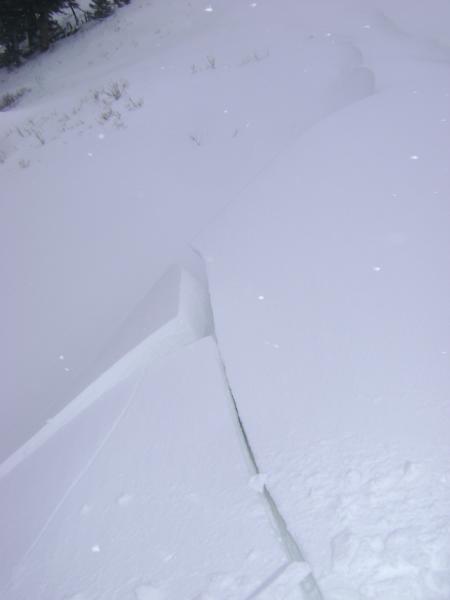
recent activity Ogden area mountains: Cracking of wind drifts and very poor structure.
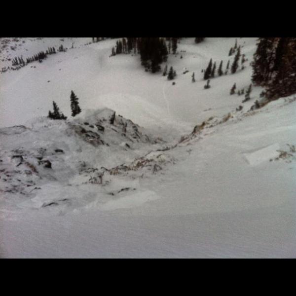
Salt Lake mnts: An intentional cornice drop yesterday triggered a hard slab to the ground, 3' deep by 50', on a very steep, north facing slope at 10,000. 3 large collapses triggered by a group walking the Big Cottonwood - Mill Creek ridge line.
Park City Ridge line: Natural cornice drops on a north facing slopes triggered slides on a November rain crust along the Park City ridgeline. Explosive control work at resorts on the Park City side had mixed results, with only one slide triggered – a hard slab 8-18” deep and 75’ wide. |
Avalanche Problem 1over the next 24 hours
| type | aspect/elevation | characteristics |
|---|
 |


Above 8,500 ft.
7,000-8,500 ft.
Below 7,000 ft.
|
|
|
description
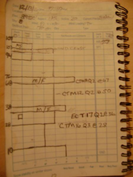
Yesterday’s avalanche activity and collapses are more than enough information. The weak crusts and facets in our snowpack are on edge – and the weight of a person can tip the balance. Weak layers are most widespread on east through north into northwest, at both the mid and upper elevations. Faceted weak layers mean you can release avalanches from a distance, or they can be stubborn, and wait for the third person or until you are mid slope and break out above you. Poor Structure, Ogden area mountains:
|

Avalanche Problem 2over the next 24 hours
| type | aspect/elevation | characteristics |
|---|
 |
Above 8,500 ft.
7,000-8,500 ft.
Below 7,000 ft.
|
|
|
description
Hard drifts of windblown snow still litter the landscape, of widely varying sizes and distribution. Today’s southeasterly through westerly winds will just complicate the pattern. Work hard to identify, and then avoid, both the old, soon to be hidden, wind drifts and the new drifts on steep slopes. |
 |
weather A series of storms will add significant snow to the mountains over the next week. Today, mostly cloudy skies and occasional light snow, adding up to an inch or two. 10,000’ temperatures will remain mild, slowly dropping to near 20 this afternoon, and then into the low teens by Saturday morning. The winds will gradually shift to the southwest and then west, decreasing slightly. Snowfall amounts by midday Saturday will be in the 4 to 9” range, with areas favored by westerly flow receiving the high end. The heaviest snow should be between about 6 pm tonight through midnight. A brief break is expected late Saturday and Saturday night, with another storm on a southwesterly flow for Sunday into Monday, followed by a strong cold front Tuesday into Wednesday. |
| general annoucements Go to http://www.backcountry.com/utah-avalanche-center to get tickets from our partners at Ala, Beaver Mountain, Brighton, Canyons, Deer Valley, Park City, Powder Mountain, Snowbasin, Snowbird, Solitude, Sundance, and Wolf Mountain. All proceeds benefit the Utah Avalanche Center. If you trigger an avalanche in the backcountry - especially if you are adjacent to a ski area – please call the following teams to alert them to the slide and whether anyone is missing or not. Rescue teams can be exposed to significant hazard when responding to avalanches, and do not want to do so when unneeded. Thanks. Salt Lake and Park City – Alta Central (801-742-2033), Canyons Resort Dispatch (435-615-3322) Ogden – Snowbasin Patrol Dispatch (801-620-1017) Powder Mountain Ski Patrol Dispatch (801-745-3773 ex 123) Provo – Sundance Patrol Dispatch (801-223-4150) Dawn Patrol Forecast Hotline, updated by 05:30: 888-999-4019 option 8. Twitter Updates for your mobile phone - DETAILS Daily observations are frequently posted by 10 pm each evening. Subscribe to the daily avalanche advisory e-mail click HERE. UDOT canyon closures UDOT at (801) 975-4838 Wasatch Powderbird Guides does daily updates about where they'll be operating on this blog http://powderbird.blogspot.com/ . Remember your information can save lives. If you see anything we should know about, please participate in the creation of our own community avalanche advisory bysubmitting snow and avalanche conditions. You can also call us at 801-524-5304 or 800-662-4140, or email by clicking HERE Donate to your favorite non-profit –The Friends of the Utah Avalanche Center. The UAC depends on contributions from users like you to support our work. This advisory is produced by the U.S. Forest Service, which is solely responsible for its content. It describes only general avalanche conditions and local variations always exist. Specific terrain and route finding decisions should always be based on skills learned in a field-based avalanche class. |