25th Annual Black Diamond Fall Fundraising Party
Thursday, September 13; 6:00-10:00 PM; Black Diamond Parking Lot
25th Annual Black Diamond Fall Fundraising Party
Thursday, September 13; 6:00-10:00 PM; Black Diamond Parking Lot
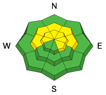
| Advisory: Moab Area Mountains | Issued by Drew Hardesty for Sunday - March 4, 2018 - 7:03am |
|---|

|
bottom line Areas of MODERATE danger exist for human triggered avalanches 1- 3' deep. These will be most pronounced at and above treeline on steep northwest to north to southeasterly facing slopes. The danger for new snow instabilities may also rise to MODERATE as the snow will bond poorly to the old snow surfaces in the steeper terrain. The best and safest riding conditions can be found on low angle shady, wind sheltered slopes with no overhead hazard.
|
 |
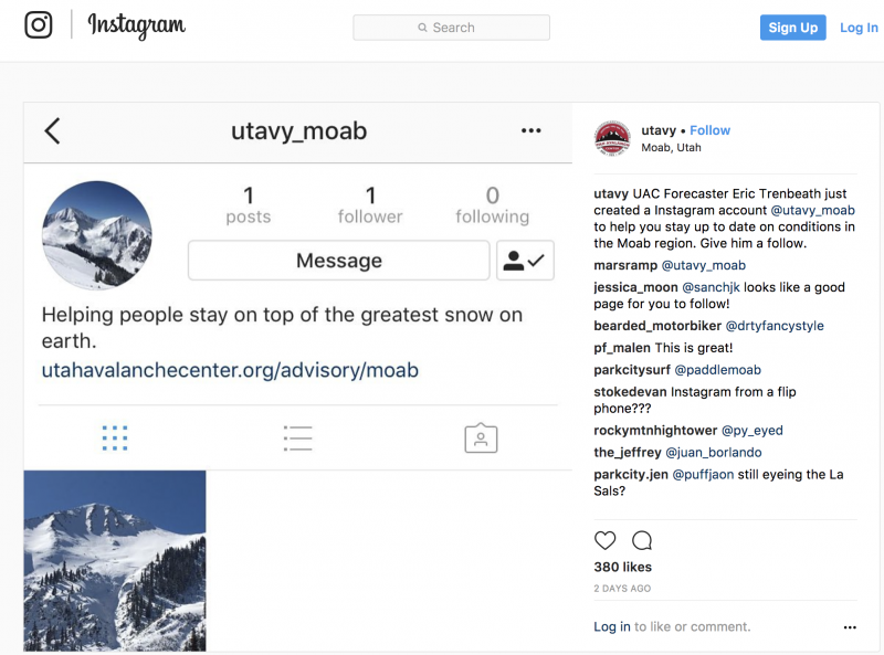
special announcement UAC Moab (La Sals/Abajos) forecaster Eric Trenbeath and I are on a short exchange. He'll be taking my shifts in the UAC - Salt Lake office this weekend. I'll have forecasts up for the La Sals through Sunday and for the Abajos on Saturday and Sunday. If anything needs my attention or if there are pertinent snow, weather, or avalanche observations, please submit an observation or email or call me directly: [email protected] or 801.842.8519. Thanks - Episode 6 of the UAC podcast "A Conversation with Tom Kimbrough" is live. We explore ideas about lifetime exposure to risk and what role Buddhism has played in his life as a climber, skier, and soon-to-be octogenarian. We talk about what has changed over the years in snow science and the role of mentorship in the world of avalanche forecasting and other professions and pursuits. Check it out on ITunes, Stitcher, the UAC blog. The UAC Marketplace is still open. Our online marketplace still has deals on skis, packs, airbag packs, beacons, snowshoes, soft goods and much more. INSTAGRAM! We now have a UAC-Moab Instagram page. You can find it here....but better yet follow us on your smartphone. Confused? Ask a teenager.
|
 |
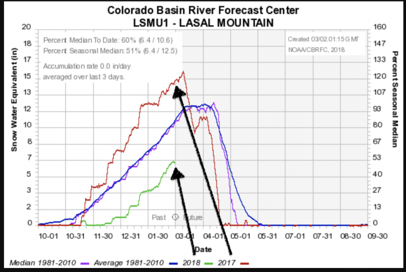
current conditions Hints of the storm are in the air with cumulus over the mountains and more clouds to the west. Pre-frontal southerly winds remain strong, blowing 35 with gusts to 50 at Pre-Laurel. Temperatures have cooled a bit from yesterday's overnight lows and are in the upper teens to upper 20s. Geyser Pass nearly reached 45°F yesterday. Looks as if the storm should be arriving in the next few hours - 9am to mid-morning with models suggesting an optimisic 3-6". Still, this will help the widespread areas of sun and wind damage throughout the range. We got out into the La Sals on Thursday and again yesterday. You can find the reports below. Base depth in Gold Basin: 35" Base depth at Geyser Pass Trailhead: 23" New snow totals in Gold Basin. Snow totals at the Geyser Pass Trailhead, (9600') Wind, temperature, and humidity on Pre Laurel Peak (11,700') Road conditions to Geyser Pass Trailhead: The road is snowpacked and icy in places. Good tires and at least front-wheel drive recommended. Grooming conditions: Trails were rolled out into Gold Basin mid-week. A look at this season compared to last year..and the average. The below graph is from the NRCS La Sals Snotel site at roughly 9570'. We are currently 60% of average - and - well off of last year's banner snowpack season. Pray for snow.
|
 |
recent activity The last reported avalanche occurred just over a week ago on February 22nd - the large natural in the Gravel Pit Lanes - the NE face of Tukno 3.5' deep and 150' wide. Since then, the only known avalanches have been shallow natural wind pockets releasing in the high alpine in the wind zone. The strong southerlies ripping along the ridgelines may also contribute to two avalanche problems:
Your information to us helps to save lives. Reports of avalanches, cracking, collapsing or any other information makes a difference. It's easy to do, even from your smartphone. Thanks - |
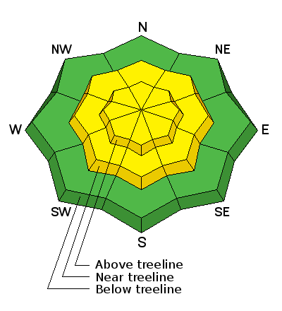
| type | aspect/elevation | characteristics |
|---|

|
|
LIKELIHOOD
 LIKELY
UNLIKELY
SIZE
 LARGE
SMALL
TREND
 INCREASING DANGER
SAME
DECREASING DANGER
|
|
description
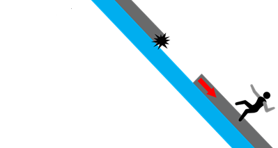
Avalanches stepping into old early season snow 1-3' deep remains far and away the most significant and unsurvivable avalanche problem. The poor structure has gone mostly dormant in the past week, but additional stress of wind loading is rarely a good thing. For now, I'd put this firmly in the Low Probabilty - High Consequence regime. Potential triggers include cornice fall, people or snowmobiles "catching air" and landing hard in the starting zone...or just finding a thin weak spot on the slope. Even though no avalanches, cracking or collapsing is present...and snow tests show a fairly dormant structure, it's enough to keep a conservative approach. With benign weather later this week, this problem may become completely dormant. |
| type | aspect/elevation | characteristics |
|---|

|
|
LIKELIHOOD
LIKELY
UNLIKELY
SIZE
 LARGE
SMALL
TREND
INCREASING DANGER
SAME
DECREASING DANGER
|
|
description
Hard wind slabs are prevalent on many aspects and elevations and will remain stubborn (but not impossible) for human triggering. They tend to break well above you on the slope, especially as you near the tapered portion of the teardrop where the slab becomes much thinner. Listen for hollow sounds and collapsing...but these may not be present at all. Lastly, avoid being on or beneath heavily corniced ridgelines as they may fail on approach or without warning. The Tuk ridgeline was sporting some large cornice development yesterday.
|
| type | aspect/elevation | characteristics |
|---|

|
|
LIKELIHOOD
 LIKELY
UNLIKELY
SIZE
 LARGE
SMALL
TREND
 INCREASING DANGER
SAME
DECREASING DANGER
|
|
description
I expect any new snow to bond poorly to the slick underlying bed surfaces and some areas where loose snow exists over old crusts. Sluffing is expected and should happen naturally on slopes approaching 40° and steeper. Shallow wind slab avalanches are also possible above treeline but both issues should respond well to ski cuts and simple observations. Again, terrain choices either amplify or diminish the overall risk. Otherwise harmless sluffs can be problematic in and above high consequence terrain. |
 |
weather Frontal passage is due this morning with 3-6" expected in the mountains. Temperatures at 10,000' may drop as low as the upper single digits overnight but slowly start to rebound over the course of the week. Winds will remain gusty with the wind shift from south to west to northwest, with gusts along the ridgelines into the 40s. Skies should start to clear overnight with high pressure moving in for the week. Another storm perhaps on tap for next weekend. |
| general announcements The UAC has new support programs with Outdoor Research and Darn Tough. Support the UAC through your daily shopping. When you shop at Smith's, or online at Outdoor Research, REI, Backcountry.com, Darn Tough, Patagonia, NRS, Stio, Amazon, and eBay a portion of your purchase will be donated to the FUAC. See our Donate Page for more details on how you can support the UAC when you shop. Benefit the Utah Avalanche Center when you buy or sell on eBay - set the Utah Avalanche Center as a favorite non-profit in your eBay account here and click on eBay gives when you buy or sell. You can choose to have your seller fees donated to the UAC, which doesn't cost you a penny. This information does not apply to developed ski areas or highways where avalanche control is normally done. This advisory is from the U.S.D.A. Forest Service, which is solely responsible for its content. This advisory describes general avalanche conditions and local variations always occur. |