| Please join us at the 23rd annual Black Diamond Fall Fundraiser Party Thursday Sept 15. Tickets are on sale now here, at the Black Diamond store & at REI. Special bonus raffle for online ticket purchasers! |
| Please join us at the 23rd annual Black Diamond Fall Fundraiser Party Thursday Sept 15. Tickets are on sale now here, at the Black Diamond store & at REI. Special bonus raffle for online ticket purchasers! |
| Advisory: Moab Area Mountains | Issued by Eric Trenbeath for Sunday - December 13, 2015 - 7:23am |
|---|

|
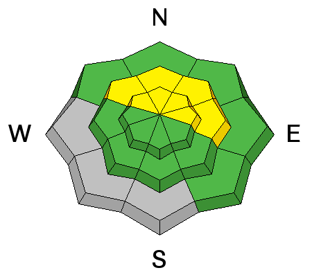
bottom line Today there is a MODERATE danger for triggering a recently deposited wind slab in exposed terrain that faces N-NE-E right around tree line and above. You may also be able to trigger an older, stiff wind slab in these same areas. There is also the possibility that a triggered wind slab could step further down into older, weak, sugary snow causing a persistent slab avalanche. With snow in the forecast, the danger could rise to CONSIDERABLE by tomorrow.
|
 |
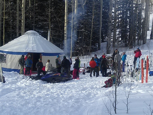
special announcement The Utah Avalanche Center-Moab will be presenting a free Know Before You Go avalanche awareness presentation at the Grand County Library on Thursday, December 17 at 6:30 p.m. Call the Manti-La Sal National Forest office at 435-259-7155 fro more information. And thanks to Moab Cliffs and Canyons, Moab Gear Trader, and Talking Mountain Yurts for making yesterday's beacon clinic a success!
|
 |
current conditions It was a beautiful day in the mountains yesterday with the 3" of new snow freshening things up surprisingly well. Forecasted winds never materialized until very late in the day, and even then, only bumping up into the 20 mph range along ridge tops from the WNW. It is currently 13 degrees in Gold Basin and 21 at the Geyser Pass Trailhead. WNW winds are continuing to average 15-20 mph along ridge tops. Base depth in Gold Basin: 30" Base depth at Geyser Pass Trailhead: 20" Winds, temperature and humidity on Pre-Laurel Peak New snow totals, temperature and humidity in Gold Basin Total snow depth and temperature at Geyser Pass Trailhead
|
 |
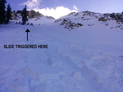
recent activity A skier triggered avalanche occurred yesterday in Gold Basin. Varying from 3" to 12" deep, the slide perfectly fit the criteria for a forecasted isolated danger of triggering a shallow wind slab formed earlier in the week that had then by covered by new snow. The slab ran on a faceted weak layer, and which serves as a portent for future persistent slab problems. No one was caught or carried, and the skier was able to quickly ski out of it. You can read more about it here.
|
| type | aspect/elevation | characteristics |
|---|

|
|
LIKELIHOOD
 LIKELY
UNLIKELY
SIZE
 LARGE
SMALL
TREND
 INCREASING DANGER
SAME
DECREASING DANGER
|
|
description
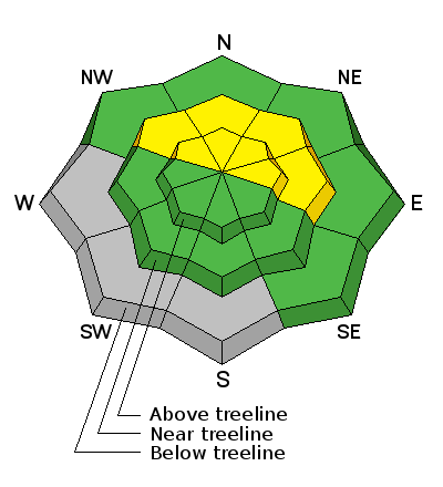
Strong westerly winds over the past week have formed isolated, stiff, shallow wind slabs on N-NE-E aspects in upper elevation, wind exposed terrain. Additionally, the snow that fell yesterday has been moved around a bit, forming soft drifts along the lee sides of upper elevation ridge crests. Though mostly shallow, these slabs could knock you off your feet and take you for a ride over cliffs or rocks. And in some cases, it may be possible to trigger a wind slab and have it step down into buried, weak sugary snow causing a persistent slab avalanche. Suspect areas with a smooth rounded appearance that may even have a hollow feel to them. |
| type | aspect/elevation | characteristics |
|---|

|
|
LIKELIHOOD
 LIKELY
UNLIKELY
SIZE
 LARGE
SMALL
TREND
INCREASING DANGER
SAME
DECREASING DANGER
|
|
description
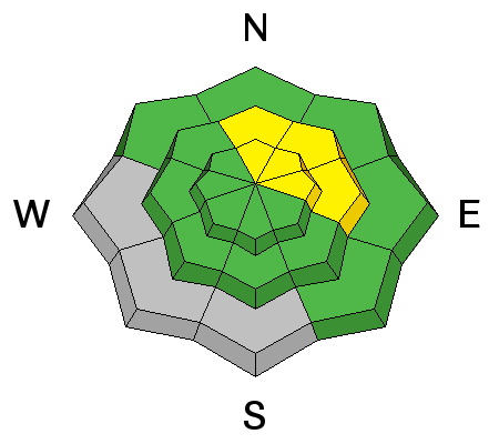
Persistent weaknesses exist in the snowpack, and there are areas where stiff wind slabs overly these weaknesses. Though the danger isn't wide spread at this time, it is possible to trigger a persistent slab on shady, northerly aspects on slopes steeper than 35 degrees. Particularly in areas of featured, more extreme terrain. With snow in the forecast early this week, expect the persistent slab danger to rise and become more widespread.
|
 |
weather Today will be a sunny day in the mountains before the next storm approaches on Monday. This looks like it could be a little more significant for us with 6-12" possible. Today Mostly sunny, with a high near 24. North wind 5 to 15 mph becoming west southwest in the afternoon. Tonight A 40 percent chance of snow, mainly after 1am. Mostly cloudy, with a low around 16. Breezy, with a south southwest wind 10 to 15 mph increasing to 15 to 20 mph after midnight. Winds could gust as high as 30 mph. Monday Snow. High near 18. Windy, with a south wind 25 to 30 mph decreasing to 15 to 20 mph in the afternoon. Winds could gust as high as 45 mph. Chance of precipitation is 80%. New snow accumulation of 4 to 8 inches possible. Monday Night Snow. Low around 2. Wind chill values as low as -15. Breezy, with a west northwest wind 15 to 20 mph. Chance of precipitation is 80%. New snow accumulation of 3 to 5 inches possible. Tuesday Snow likely. Mostly cloudy, with a high near 14. Blustery, with a north northwest wind 15 to 20 mph, with gusts as high as 30 mph. Chance of precipitation is 60%. |
| general announcements The Road to the Geyser Pass Trailhead was sufficiently packed in yesterday by lots of traffic. Matt got up and groomed yesterday so it is game on! Thanks for sending in your observations. You can view Moab observations here. To post an observation go here. To receive this advisory by email go here. This information does not apply to developed ski areas or highways where avalanche control is normally done. This advisory is from the U.S.D.A. Forest Service, which is solely responsible for its content. This advisory describes general avalanche conditions and local variations always exist. |