
| During the month of April, Mark Miller will donate $75 to the charity of your choice (5 to chose from, including the Utah Avalanche Center!) Mark Miller Subaru has raised over $300k in the previous 6 Do Good Feel Good events. More Info here |  |
| During the month of April, Mark Miller will donate $75 to the charity of your choice (5 to chose from, including the Utah Avalanche Center!) Mark Miller Subaru has raised over $300k in the previous 6 Do Good Feel Good events. More Info here | |
| Advisory: Moab Area Mountains | Issued by Eric Trenbeath for Thursday - March 12, 2015 - 7:29am |
|---|

|
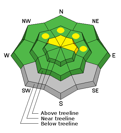
bottom line There still remains an isolated or MODERATE danger for triggering a dangerous persistent slab. This danger is most prevalent on steep rocky terrain, right around tree line and above on slopes that have a NW-N-E aspect. Elsewhere the avalanche danger is generally LOW.
|
 |
current conditions La Sal Mountains Typical mixed bag spring conditions exist. Winds have continued to behave through the week, and you can still find settled, re-crystallized powder on sheltered, northerly aspects at upper elevations. Crusts abound on sun exposed aspects, and with the clouds and chance of snow today, I wouldn't expect them to soften. Light SW winds overnight have shifted to the NW this morning. Temperatures are in the mid 20's. La Sal Mountains Current Weather Wind speeds and temperature at 11,700' on Pre-Laurel Peak. New snow totals and temperature at Geyser Pass Trailhead. New snow totals and temperature in Gold Basin. Abajo / Blue Mountains Mixed bag conditions and overall low coverage remain the order in the Abajos. Northerly aspects at upper elevations have as much as 4' of snow, while wind and sun exposed slopes are still showing rocks and grass. Abajo / Blue Mountains Current Weather Winds and temperature on Abajo Peak. Snow total at Buckboard Flat.
|
 |
recent activity
|
| type | aspect/elevation | characteristics |
|---|

|
|
LIKELIHOOD
 LIKELY
UNLIKELY
SIZE
 LARGE
SMALL
TREND
 INCREASING DANGER
SAME
DECREASING DANGER
|
|
description
Time and warm temperatures have settled out much of the persistent slab danger and people have begun pushing into larger terrain. Nevertheless, an isolated danger for triggering a persistent slab still exists, and being able to predict exactly where and when will be a little bit like rolling the dice. One thing is for sure, once triggered, a slide of this type will be large and dangerous. I would still continue to avoid more extreme terrain, particularly right around, and just above tree line on steep rocky slopes that face the north half of the compass. Check out this video on persistent slabs from Trent Meisenheimer at the UAC up in SLC.
|
 |
weather High level moisture on a SW flow has begun streaming over the 4 Corners region. Today look for cloudy skies and 1"-3" of new snow possible. Winds will be from the WNW averaging 5-10 mph. Winds will be in the increase tonight with a continued chance for light snow. Things move out of here on Friday with high, dry, and warm conditions ahead for the weekend. |
| general announcements Observations: If you are out and about, I would love to know what you are seeing. Please post your observations here. EMAIL ADVISORY If you would like to get the daily advisory by email you will need to subscribe here. Benefit the Utah Avalanche Center when you shop from Backcountry.com or REI: Click this link for Backcountry.com or this link to REI, shop, and they will donate a percent of your purchase price to the UAC. Both offer free shipping (with some conditions) so this costs you nothing! Benefit the Utah Avalanche Center when you buy or sell on ebay - set the Utah Avalanche Center as a favorite non-profit in your ebay account here and click on ebay gives when you buy or sell. You can choose to have your seller fees donated to the UAC, which doesn't cost you a penny. This advisory is from the U.S.D.A. Forest Service, which is solely responsible for its content. This advisory describes general avalanche conditions and local variations always exist. |


_2.jpg)
