
| During the month of April, Mark Miller will donate $75 to the charity of your choice (5 to chose from, including the Utah Avalanche Center!) Mark Miller Subaru has raised over $300k in the previous 6 Do Good Feel Good events. More Info here |  |
| During the month of April, Mark Miller will donate $75 to the charity of your choice (5 to chose from, including the Utah Avalanche Center!) Mark Miller Subaru has raised over $300k in the previous 6 Do Good Feel Good events. More Info here | |
| Advisory: Moab Area Mountains | Issued by Eric Trenbeath for Friday - February 27, 2015 - 6:47am |
|---|

|
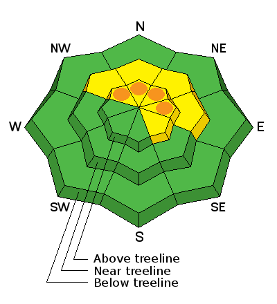
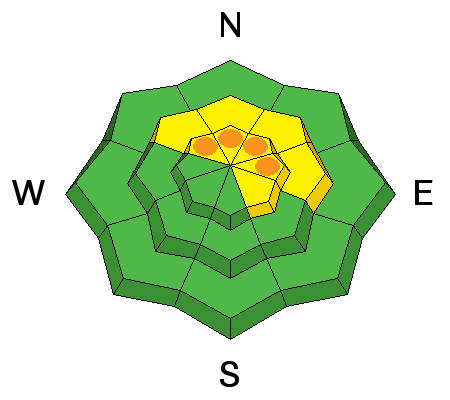
bottom line In the Abajo Mountains there is a MODERATE or heightened danger for triggering both wind slab and deeper, persistent slab avalanches. Due to the variable distribution of snow, some areas have pockets of CONSIDERABLE danger. Areas of greatest danger are steep, northerly facing slopes. In the La Sal Mountains there is a MODERATE danger for triggering recently deposited shallow wind slabs, primarily on upper elevation, wind exposed terrain.
|
 |
current conditions La Sal Mountains The mountains picked up about 3" of refresher snow overnight. This will improve conditions a but but in most areas you can still feel the hard underlying surface. Exceptions are sheltered areas where the snow has drifted in or where soft, re-crystallized snow existed before last weekend's storm. Above tree line, winds during the past week have scoured exposed areas and the sun mid week put a thin crust on exposed slopes. Winds overnight have been light and westerly and overnight lows were right around 20 degrees. La Sal Mountains Current Weather Wind speeds and temperature at 11,700' on Pre-Laurel Peak. New snow totals and temperature at Geyser Pass Trailhead. New snow totals and temperature in Gold Basin. Abajo / Blue Mountains The Abajos picked up a couple of inches overnight but snow cover in the range is still very thin. "Spatial variability" is the key term. This means you can find snow up to four feet deep on on a sheltered, northerly aspect while a more exposed, adjacent slope will still be showing rocks and grass. Winds during the week have moved snow around and even stripped it away on many slopes that were bare prior to last week's storm. Good powder conditions can still be found on sheltered northerly aspects. Sun exposed slopes have developed a thin crust. Abajo / Blue Mountains Current Weather Winds and temperature on Abajo Peak. Snow total at Buckboard Flat.
|
 |
recent activity
|
| type | aspect/elevation | characteristics |
|---|

|
|
LIKELIHOOD
 LIKELY
UNLIKELY
SIZE
 LARGE
SMALL
TREND
 INCREASING DANGER
SAME
DECREASING DANGER
|
|
description
La Sal Mountains I don't expect the new snow today to affect the avalanche danger much nevertheless, as snow begins to accumulate, be alert to new soft slab formation and signs of instability such as cracking in the snow surface. The new snow will also be covering isolated, stiff, winds slabs formed that formed mid week on the the lee sides of ridges and terrain features. Though they have gained strength and will be stubborn to move today, continue to suspect smooth, rounded deposits of wind drifted snow, particularly in steep and more radical terrain. Abajo / Blue Mountains In the Abajo mountains, stiff wind slabs up to 2' deep have formed at upper elevations on the lee sides of ridge crests and terrain features. On shady aspects these slabs are overlying a weak and faceted snow pack, and the danger exists for a triggered, newly deposited wind slab, to step down into older weak layers creating a larger and even more dangerous avalanche. Avoid steep terrain and be alert to signs of instability such as cracking in the snow surface and suspect smooth, rounded deposits of wind drifted snow. |
| type | aspect/elevation | characteristics |
|---|

|
|
LIKELIHOOD
LIKELY
UNLIKELY
SIZE
LARGE
SMALL
TREND
 INCREASING DANGER
SAME
DECREASING DANGER
|
|
description
In my travels yesterday in the Abajo Mountains, I observed areas of collapsing which means the weight of the new snow is overriding the strength of the underlying weak, sugary, "faceted snow." This means a rider triggering an avalanche in the new snow risks the potential of having a slide step down into buried weak layers creating a much larger and more dangerous "persistent slab" avalanche. This danger is most prevalent on slopes steeper than about 35 degrees that have a NW-N-E aspect. |
 |
weather A long duration precipitation event, similar to last weekend, is on track to affect our area through early next week. Today look for developing snow showers with a couple of inches possible. A few more inches are possible tonight with the best shot looking to be on Saturday and Sunday. High temperatures at 10,000' will be in the low to mid 20's and ridge top winds will be in the 10-15 mph range from the SW. Today: Snow showers, mainly after 11am. Some thunder is also possible. High near 23. Southwest wind 5 to 15 mph. Chance of precipitation is 80%. Total daytime snow accumulation of 1 to 3 inches possible. |
| general announcements Observations: If you are out and about, I would love to know what you are seeing. Please post your observations here. EMAIL ADVISORY If you would like to get the daily advisory by email you will need to subscribe here. Benefit the Utah Avalanche Center when you shop from Backcountry.com or REI: Click this link for Backcountry.com or this link to REI, shop, and they will donate a percent of your purchase price to the UAC. Both offer free shipping (with some conditions) so this costs you nothing! Benefit the Utah Avalanche Center when you buy or sell on ebay - set the Utah Avalanche Center as a favorite non-profit in your ebay account here and click on ebay gives when you buy or sell. You can choose to have your seller fees donated to the UAC, which doesn't cost you a penny. This advisory is from the U.S.D.A. Forest Service, which is solely responsible for its content. This advisory describes general avalanche conditions and local variations always exist. |


_2.jpg)