
| During the month of April, Mark Miller will donate $75 to the charity of your choice (5 to chose from, including the Utah Avalanche Center!) Mark Miller Subaru has raised over $300k in the previous 6 Do Good Feel Good events. More Info here |  |
| During the month of April, Mark Miller will donate $75 to the charity of your choice (5 to chose from, including the Utah Avalanche Center!) Mark Miller Subaru has raised over $300k in the previous 6 Do Good Feel Good events. More Info here | |
| Advisory: Moab Area Mountains | Issued by Eric Trenbeath for Sunday - February 22, 2015 - 6:35am |
|---|

|
bottom line Expect the avalanche danger to rise to MODERATE today as new wind drifts begin to develop at upper elevations and on the lee sides of terrain features. The danger will continue to rise over the next two days as a significant storm system affects our area.
|
 |
special avalanche bulletin A powerful and prolonged storm system will affect our area through Tuesday with 1-2 feet of snow possible in the mountains. Expect a rising avalanche danger over the next several days with human triggered avalanches becoming likely by Monday. Backcountry travelers are advised to maintain a strong awareness of changing conditions and plan their routes accordingly. |
 |
current conditions Old man winter is returning to Southern Utah bringing colder temperatures and what looks to be a fair amount of that white stuff falling out of the sky over the next couple of days. Conditions will still be a bit rugged this morning as new snow begins to cover a variety of textured and frozen surfaces. Things should improve later in the day with 3-7" in the forecast. Overnight lows again dropped into the very wintry single digits on Pre Laurel Peak, and ridge top winds have been very light averaging less than 10 mph from the WSW. It is currently 20 degrees at the Geyser Pass Trailhead and 15 in Gold Basin.
La Sal Mountains Current Weather Wind speeds and temperature at 11,700' on Pre-Laurel Peak. New snow totals and temperature at Geyser Pass Trailhead. New snow totals and temperature in Gold Basin. Abajo / Blue Mountains. Low snow conditions continue to plague the Abajo Mountains. Winds and temperature on Abajo Peak. Snow total at Buckboard Flat.
|
 |
recent activity
|
| type | aspect/elevation | characteristics |
|---|

|

|
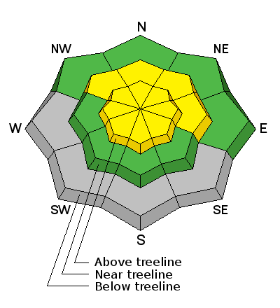
LIKELIHOOD
 LIKELY
UNLIKELY
SIZE
 LARGE
SMALL
TREND
 INCREASING DANGER
SAME
DECREASING DANGER
|
|
description
The main concern today will be fresh drifts and shallow soft slabs within the new snow. Winds are forecasted to remain fairly light from the NE but pay attention to increasing sensitivity through the course of the day. Look for signs of instability such as cracking in the new snow and be aware of drifting on the lee sides of terrain features. By tomorrow expect the danger to rise as new snow piles up and drifts become deeper and more widespread. |
 |
weather A complicated and prolonged winter storm system has moved into our area. Look for snow in the mountains today with 3-7" possible. Ridge top winds will be from the NE averaging 10-15 mph and shifting to more southeasterly by tonight. High temps at 10,000' will be in the low 20's. 6-10" of snow are possible tonight with more snow continuing through Monday and in to Tuesday. |
| general announcements
EMAIL ADVISORY If you would like to get the daily advisory by email you will need to subscribe here. Benefit the Utah Avalanche Center when you shop from Backcountry.com or REI: Click this link for Backcountry.com or this link to REI, shop, and they will donate a percent of your purchase price to the UAC. Both offer free shipping (with some conditions) so this costs you nothing! Benefit the Utah Avalanche Center when you buy or sell on ebay - set the Utah Avalanche Center as a favorite non-profit in your ebay account here and click on ebay gives when you buy or sell. You can choose to have your seller fees donated to the UAC, which doesn't cost you a penny. This advisory is from the U.S.D.A. Forest Service, which is solely responsible for its content. This advisory describes general avalanche conditions and local variations always exist. |


_2.jpg)