| During the month of April, Mark Miller will donate $75 to the charity of your choice (5 to chose from, including the Utah Avalanche Center!) Mark Miller Subaru has raised over $300k in the previous 6 Do Good Feel Good events. More Info here |  |
| During the month of April, Mark Miller will donate $75 to the charity of your choice (5 to chose from, including the Utah Avalanche Center!) Mark Miller Subaru has raised over $300k in the previous 6 Do Good Feel Good events. More Info here | |
| Advisory: Moab Area Mountains | Issued by Eric Trenbeath for Monday - January 19, 2015 - 6:56am |
|---|

|
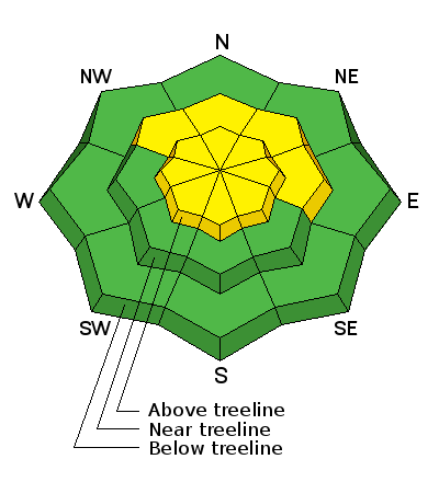
bottom line There is a MODERATE danger for triggering a recently deposited wind slab on all aspects steeper than 35 degrees, primarily at upper elevations, in areas that you can detect recent deposits of wind drifted snow. There also remains a MODERATE danger of triggering a persistent slab on steep, upper elevation slopes with a NW-N-E aspect, particularly in rocky areas that have a thin snowpack.
|
 |
special announcement This advisory is based on field work performed on Sunday, January 18 and weather observations taken on Monday, January 19. It is to be used as a baseline for forming your own danger analysis for the upcoming week. Little change in the weather or in the avalanche conditions is expected for the next several days, but mountain weather conditions can change without warning. Use the weather links provided under the current conditions section to stay abreast of wind, temperature and new snowfall. The next advisory will be updated on Thursday, January 22. |
 |
current conditions La Sal Mountains Conditions are becoming more mixed out there. Wind from all directions and a strong sun have affected the snow surface in exposed locations. Best bet for good "recycled" powder conditions is on sheltered slopes below tree line. Base depth in Gold Basin is 44" and 32" at the Geyser Pass Trailhead. Thanks to everyone who has posted recent observations. Wind speeds and temperature at 11,700' on Pre-Laurel Peak. New snow totals and temperature at Geyser Pass Trailhead. New snow totals and temperature in Gold Basin. Abajo / Blue Mountains. Low snow conditions prevail but soft powder can be found on sheltered terrain below tree line. In these areas the base depth ranges from 20-30" of snow. Sunnier aspects remain extremely shallow as most were down to bare ground prior to last week's storm. For an observation report from Friday, January 16 click here. Winds and temperature on Abajo Peak. Snow total at Buckboard Flat.
|
 |
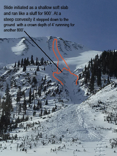
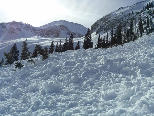
recent activity A significant avalanche that was likely skier triggered occurred on the afternoon of January 17. It initiated as a soft slab high on the NE face of Tukno. It ran for 900' until it reached a steep convexity at which point it broke to the ground with a 4' deep fracture. It then ran for another 800' down into Tele Heaven. A pair of ski tracks were observed high on the slope as well as exiting the area. Tracks from two local skiers who had been in the area earlier were partially covered by the slide.
The storm on Monday, January 12 produced several storm slab avalanches with at least one that stepped down into persistent weak layers. Here is a list of the most recent avalanches. |
| type | aspect/elevation | characteristics |
|---|

|
|
LIKELIHOOD
 LIKELY
UNLIKELY
SIZE
 LARGE
SMALL
TREND
 INCREASING DANGER
SAME
DECREASING DANGER
|
|
description
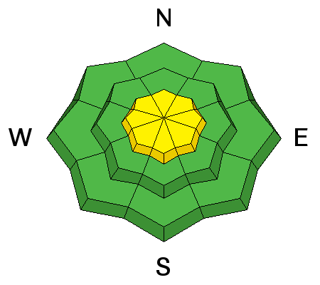
Stiff wind slabs remain in upper elevation terrain along ridge crests and on the lee sides of terrain features. Variable winds over the past week have made it possible to find these slabs on all aspects. Avoid slopes steeper than 35 degrees in areas where you can detect recent deposits of wind drifted snow. Look for smooth rounded pillows that have a hollow feel to them, and watch for signs of instability such as cracking in the snow surface. |
| type | aspect/elevation | characteristics |
|---|

|
|
LIKELIHOOD
LIKELY
UNLIKELY
SIZE
 LARGE
SMALL
TREND
INCREASING DANGER
SAME
DECREASING DANGER
|
|
description
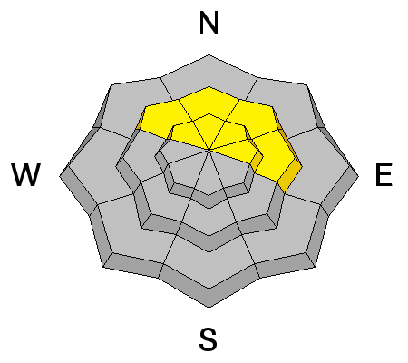
Conditions are down right spooky out there. Though signs of instability aren't always presenting themselves, two wind slab releases in the past week, one possibly skier triggered, have stepped down into buried persistent weaknesses producing large and dangerous avalanches. In short, I am extremely leery. The danger remains for triggering one of these deep persistent slabs on upper-mid to upper elevation slopes steeper than 35 degrees that have a NW-N-E aspect, particularly in areas of rocky terrain that have a thin shallow snowpack. |
 |
weather Conditions will be mostly high and dry this week with a couple of shortwave troughs, one to the north and one to the south bringing some clouds to our area Monday, and again on Wednesday. Monday will be the warmest day with high temperatures at 10,000' in the mid 30's and then hovering around 30 for the remainder of the week. Overnight lows will drop into the teens. M.L.King Day: Partly sunny, with a high near 36. West wind 10 to 15 mph. |
| general announcements
Grooming Conditions: Trails are scheduled to be groomed on Monday and Friday. Observations: If you are out and about, I would love to know what you are seeing. Please post your observations here. EMAIL ADVISORY If you would like to get the daily advisory by email you will need to subscribe here. Benefit the Utah Avalanche Center when you shop from Backcountry.com or REI: Click this link for Backcountry.com or this link to REI, shop, and they will donate a percent of your purchase price to the UAC. Both offer free shipping (with some conditions) so this costs you nothing! Benefit the Utah Avalanche Center when you buy or sell on ebay - set the Utah Avalanche Center as a favorite non-profit in your ebay account here and click on ebay gives when you buy or sell. You can choose to have your seller fees donated to the UAC, which doesn't cost you a penny. This advisory is from the U.S.D.A. Forest Service, which is solely responsible for its content. This advisory describes general avalanche conditions and local variations always exist. This advisory will be updated on Thursday, January 22. |


_2.jpg)