
| During the month of April, Mark Miller will donate $75 to the charity of your choice (5 to chose from, including the Utah Avalanche Center!) Mark Miller Subaru has raised over $300k in the previous 6 Do Good Feel Good events. More Info here |  |
| During the month of April, Mark Miller will donate $75 to the charity of your choice (5 to chose from, including the Utah Avalanche Center!) Mark Miller Subaru has raised over $300k in the previous 6 Do Good Feel Good events. More Info here | |
| Advisory: Moab Area Mountains | Issued by Eric Trenbeath for Wednesday - January 14, 2015 - 6:55am |
|---|

|
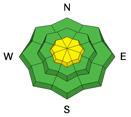
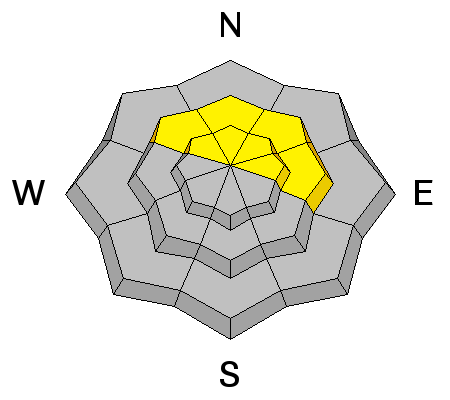
bottom line There is an overall MODERATE danger for triggering a recently deposited wind slab on all aspects steeper than 35 degrees, primarily at upper elevations, in areas that you can detect recent deposits of wind drifted snow. There also remains a MODERATE danger of triggering a persistent slab on steep, upper elevation slopes with a NW-N-E aspect, particularly in rocky areas that have a thin snowpack.
|
 |
special announcement The Utah Avalanche Center Moab will be offering a free "Know Before You Go" avalanche awareness class Thursday, January 15 at 6:30 p.m. at the Grand County Library. |
 |
current conditions La Sal Mountains Monday night's storm delivered 10-14" of much needed new snow to the La Sal Mountains and conditions are markedly improved. East north east winds were on the rise last night averaging 20-30 mph for several hours. Needless to say,some snow has been blown around at upper elevations and there will be areas of drifted and wind affected snow. Good powder conditions will still be found below tree line and on sheltered slopes. Wind speeds and temperature at 11,700' on Pre-Laurel Peak. New snow totals and temperature at Geyser Pass Trailhead. New snow totals and temperature in Gold Basin. Thanks to everyone who has been posting recent observations. You can post new observations here.
|
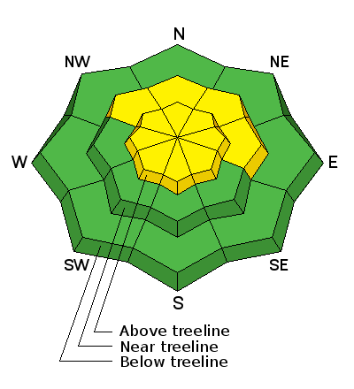
| type | aspect/elevation | characteristics |
|---|

|
|
LIKELIHOOD
 LIKELY
UNLIKELY
SIZE
 LARGE
SMALL
TREND
 INCREASING DANGER
SAME
DECREASING DANGER
|
|
description
With plenty of snow available for transport, there will be newly formed wind slabs along ridge crests and on the lee sides of terrain features. The atypical wind direction will have deposited snow on slopes with a W-SW component, but cross loading will also be a factor, and new wind slabs will likely be found on all aspects above tree line in wind exposed terrain. Stay off of slopes steeper than 35 degrees today in areas where you can detect recent deposits of wind drifted snow. |
| type | aspect/elevation | characteristics |
|---|

|
|
LIKELIHOOD
 LIKELY
UNLIKELY
SIZE
 LARGE
SMALL
TREND
 INCREASING DANGER
SAME
DECREASING DANGER
|
|
description
The weaknesses in our snowpack have not gone away and the danger remains for triggering a persistent slab on upper-mid to upper elevation slopes steeper than 35 degrees that have a NW-N-E aspect, particularly in areas of rocky terrain that have a thin shallow snowpack. |
 |
weather It looks to be a beautiful day in the mountains. Some patchy fog this morning will give way to mostly sunny skies as a ridge of high pressure develops over the region. High temperatures at 10,000' will be near 30 degrees. Winds will be light from the NE shifting to the SW. Thursday looks to be even warmer with high temperatures climbing to near 40 degrees. Mostly sunny skies remain through the weekend. |
| general announcements
Grooming Conditions: Matt is going to pack out the road with the snowmobiles today. Regular grooming is scheduled for Friday. Observations: If you are out and about, I would love to know what you are seeing. Please post your observations here. EMAIL ADVISORY If you would like to get the daily advisory by email you will need to subscribe here. Benefit the Utah Avalanche Center when you shop from Backcountry.com or REI: Click this link for Backcountry.com or this link to REI, shop, and they will donate a percent of your purchase price to the UAC. Both offer free shipping (with some conditions) so this costs you nothing! Benefit the Utah Avalanche Center when you buy or sell on ebay - set the Utah Avalanche Center as a favorite non-profit in your ebay account here and click on ebay gives when you buy or sell. You can choose to have your seller fees donated to the UAC, which doesn't cost you a penny. This advisory is from the U.S.D.A. Forest Service, which is solely responsible for its content. This advisory describes general avalanche conditions and local variations always exist. This advisory will be updated on Saturday, January 3 or sooner if conditions warrant. |


_2.jpg)