
| During the month of April, Mark Miller will donate $75 to the charity of your choice (5 to chose from, including the Utah Avalanche Center!) Mark Miller Subaru has raised over $300k in the previous 6 Do Good Feel Good events. More Info here |  |
| During the month of April, Mark Miller will donate $75 to the charity of your choice (5 to chose from, including the Utah Avalanche Center!) Mark Miller Subaru has raised over $300k in the previous 6 Do Good Feel Good events. More Info here | |
| Advisory: Moab Area Mountains | Issued by Eric Trenbeath for Tuesday - January 13, 2015 - 6:59am |
|---|

|
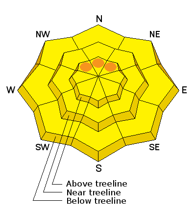
bottom line There is an overall MODERATE danger for triggering loose snow and soft slab avalanches within the new snow on all aspects steeper than 35 degrees. At upper elevations, areas of CONSIDERABLE danger may exist on slopes steeper than 35 degrees that have a NW-N-NE aspect. There also remains a MODERATE danger of triggering a persistent slab on steep, upper elevation slopes with a NW-N-E aspect, particularly in rocky areas that have a thin snowpack.
|
 |
special announcement The Utah Avalanche Center Moab will be offering a free "Know Before You Go" avalanche awareness class Thursday, January 15 at 6:30 p.m. at the Grand County Library. |
 |
current conditions La Sal Mountains What a difference a day can make! The mountains received 10-12" of new snow over the past 24 hours, most if it falling since 8 p.m. last night. Conditions today will be powder, powder, powder on all aspects. South winds between 4:00 and 8:00 p.m. yesterday blew in the low 20's with gusts near 30 mph, but when the bulk of the snow came in, they backed off to around 10 mph with occasional gusts into the high teens. Wind speeds and temperature at 11,700' on Pre-Laurel Peak. New snow totals and temperature at Geyser Pass Trailhead. New snow totals and temperature in Gold Basin. Thanks to everyone who has been posting recent observations. You can post new observations here.
|
| type | aspect/elevation | characteristics |
|---|

|
|
LIKELIHOOD
 LIKELY
UNLIKELY
SIZE
 LARGE
SMALL
TREND
 INCREASING DANGER
SAME
DECREASING DANGER
|
|
description
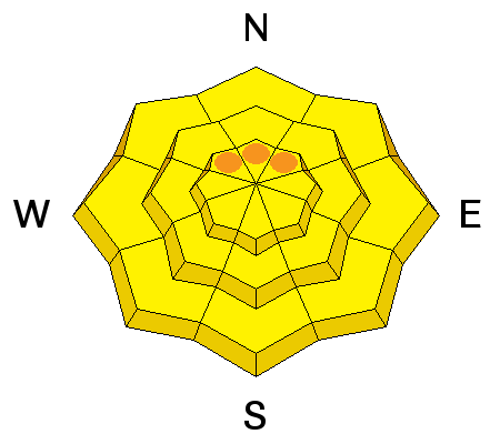
Today, expect to be able to trigger loose sluffs and sensitive soft slabs within the new snow. Though these slides won't pack a terrific punch, they have the potential to entrain a fair amount of snow. Danger will increase with elevation and as usual, steep slopes above tree line with a NW-N-NE aspect have the greatest potential for avalanche activity. Exercise caution on or under slopes steeper than about 35 degrees, and put in a ski or test cut across these slopes before committing to dropping in. |
| type | aspect/elevation | characteristics |
|---|

|
|
LIKELIHOOD
 LIKELY
UNLIKELY
SIZE
LARGE
SMALL
TREND
 INCREASING DANGER
SAME
DECREASING DANGER
|
|
description
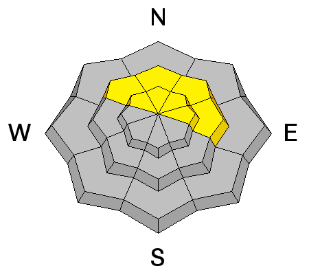
The weaknesses in our snowpack have not gone away and the danger remains for triggering a persistent slab on upper-mid to upper elevation slopes steeper than 35 degrees that have a NW-N-E aspect, particularly in areas of rocky terrain that have a thin shallow snowpack. |
 |
weather Snow showers will linger today with another 2-4" possible. South winds will be light and the high temperature at 10,000' will be around 27 degrees. Wednesday looks to be sunny as high pressure develops for the remainder of the week. |
| general announcements
Grooming Conditions: 8"-10" of new snow will be covering the trails today. Observations: If you are out and about, I would love to know what you are seeing. Please post your observations here. EMAIL ADVISORY If you would like to get the daily advisory by email you will need to subscribe here. Benefit the Utah Avalanche Center when you shop from Backcountry.com or REI: Click this link for Backcountry.com or this link to REI, shop, and they will donate a percent of your purchase price to the UAC. Both offer free shipping (with some conditions) so this costs you nothing! Benefit the Utah Avalanche Center when you buy or sell on ebay - set the Utah Avalanche Center as a favorite non-profit in your ebay account here and click on ebay gives when you buy or sell. You can choose to have your seller fees donated to the UAC, which doesn't cost you a penny. This advisory is from the U.S.D.A. Forest Service, which is solely responsible for its content. This advisory describes general avalanche conditions and local variations always exist. This advisory will be updated on Saturday, January 3 or sooner if conditions warrant. |


_2.jpg)
