
| During the month of April, Mark Miller will donate $75 to the charity of your choice (5 to chose from, including the Utah Avalanche Center!) Mark Miller Subaru has raised over $300k in the previous 6 Do Good Feel Good events. More Info here |  |
| During the month of April, Mark Miller will donate $75 to the charity of your choice (5 to chose from, including the Utah Avalanche Center!) Mark Miller Subaru has raised over $300k in the previous 6 Do Good Feel Good events. More Info here | |
| Advisory: Moab Area Mountains | Issued by Eric Trenbeath for Thursday - January 8, 2015 - 6:34am |
|---|


|
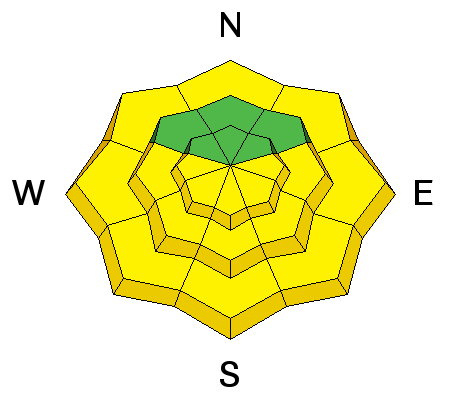
bottom line With daytime heating, the danger for wet slide activity will rise to MODERATE today, primarily on sun exposed slopes but also on northerly aspects at lower elevations. Avoid travel on or beneath steep slopes as the snow becomes wet and sloppy. Though greatly diminished, there still remains a MODERATE danger for triggering a low probability-high consequence persistent slab on slopes steeper than 35 degrees, primarily at upper mid to upper elevation terrain that has a NW-N-E aspect.
|
 |
current conditions The January thaw is turning into a heat wave and conditions are full on spring-like out there. The snow surface is a variety of breakable wind and sun crusts with only a few sporadic areas of soft powder like conditions on sheltered, upper elevation slopes. By mid day, sun exposed slopes are turning into a sloppy a mess. High temperatures at 10,000' have been getting up to around 50 degrees during the day with overnight lows dipping just below freezing. Thanks to everyone who has been posting recent observations. You can post new observations here. Wind speeds and temperature at 11,700' on Pre-Laurel Peak. New snow totals and temperature at Geyser Pass Trailhead. New snow totals and temperature in Gold Basin. |
| type | aspect/elevation | characteristics |
|---|

|
|
LIKELIHOOD
 LIKELY
UNLIKELY
SIZE
 LARGE
SMALL
TREND
 INCREASING DANGER
SAME
DECREASING DANGER
|
|
description
Unseasonably warm temperatures have brought on the danger for loose wet slide activity with the danger increasing as the day progresses. Slopes will generally be affected by their direct relationship to the sun though at lower elevations wet slufffing will also be possible on slopes with northerly aspects. Pay attention to the snow and watch for it to start feeling sloppy. Also be alert to tell tale signs of instability such as roller balls or cinnamon rolls coming down the mountain. As these signs present themselves it will be time to stay off of and out from under steep slopes. |
| type | aspect/elevation | characteristics |
|---|

|
|
LIKELIHOOD
 LIKELY
UNLIKELY
SIZE
LARGE
SMALL
TREND
 INCREASING DANGER
SAME
DECREASING DANGER
|
|
description
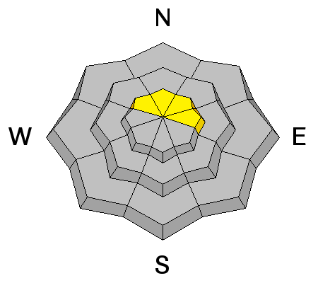
Most of the weaknesses in the snowpack are now lying dormant but it seems like we are never fully out of the woods with regards to persistent slab danger in mid winter in the La Sal Mountains. Areas of greatest concern are upper elevation slopes steeper than 35 degrees that have a NW-N-E aspect, particularly in rocky areas that have a thin snowpack. |
 |
weather It's going to be another warm sunny day in the mountains with high temperatures in the mid 40's at 10,000. Winds will be light and westerly. Clouds will move into our area Saturday with a weak disturbance brings a chance of snow on Sunday and Monday. |
| general announcements
Grooming Conditions: It should be great conditions for skating and classic cross country skiing if you get on it early. Observations: If you are out and about, I would love to know what you are seeing. Please post your observations here. EMAIL ADVISORY If you would like to get the daily advisory by email you will need to subscribe here. Benefit the Utah Avalanche Center when you shop from Backcountry.com or REI: Click this link for Backcountry.com or this link to REI, shop, and they will donate a percent of your purchase price to the UAC. Both offer free shipping (with some conditions) so this costs you nothing! Benefit the Utah Avalanche Center when you buy or sell on ebay - set the Utah Avalanche Center as a favorite non-profit in your ebay account here and click on ebay gives when you buy or sell. You can choose to have your seller fees donated to the UAC, which doesn't cost you a penny. This advisory is from the U.S.D.A. Forest Service, which is solely responsible for its content. This advisory describes general avalanche conditions and local variations always exist. This advisory will be updated on Saturday, January 3 or sooner if conditions warrant. |


_2.jpg)
