| During the month of April, Mark Miller will donate $75 to the charity of your choice (5 to chose from, including the Utah Avalanche Center!) Mark Miller Subaru has raised over $300k in the previous 6 Do Good Feel Good events. More Info here |  |
| During the month of April, Mark Miller will donate $75 to the charity of your choice (5 to chose from, including the Utah Avalanche Center!) Mark Miller Subaru has raised over $300k in the previous 6 Do Good Feel Good events. More Info here | |
| Advisory: Moab Area Mountains | Issued by Eric Trenbeath for Thursday - January 1, 2015 - 6:49am |
|---|

|
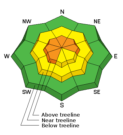
bottom line Today the danger remains CONSIDERABLE on upper elevation, wind exposed terrain on slopes steeper than 35 degrees that have a SW-N-E aspect in areas that you can detect recent deposits of wind drifted snow. There is also a "low probability-high consequence" MODERATE danger for triggering a deep persistent slab on slopes steeper than 35 degrees, primarily at upper mid to upper elevation terrain that has a NW-N-E aspect.
|
 |
current conditions The mountains picked up a few more inches of snow over night with the Gold Basin snow stake registering 5" of new. Conditions remain quite good though the ESE winds of the past couple of days have affected the snow surface in exposed areas, particularly above tree line. Overnight winds have averaged 20-25 mph from the ESE with gusts into the mid 30['s. They backed off into the teens around 4:00 a.m. Temperatures are a bit warmer this morning. It is currently 12 degrees on Pre Laurel Peak and 24 at the Geyser Pass Trailhead. Mountain weather conditions at 11,700' on Pre-Laurel Peak. Snow totals at Geyser Pass Trailhead. New snow totals in Gold Basin. |
| type | aspect/elevation | characteristics |
|---|

|
|
LIKELIHOOD
 LIKELY
UNLIKELY
SIZE
 LARGE
SMALL
TREND
 INCREASING DANGER
SAME
DECREASING DANGER
|
|
description
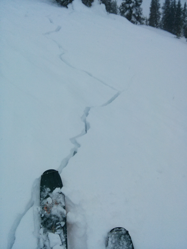
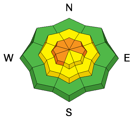
ESE winds of the past few days have deposited stiff, new wind slabs in exposed areas, primarily at upper elevations on the lee sides of ridges and terrain features. The uncommon wind direction has deposited snow in unusual places and cross loading is definitely a factor. In some areas a portion of the slope will be scoured off, and immediately adjacent, a wind slab will have formed behind a terrain feature such as a sub ridge or rock outcropping. These slabs are mostly shallow, about 6"-10" deep, but could be over a foot in some areas. They could easily knock you down in steep terrain, and once moving, they also have the potential to step down into buried, persistent weak layers. Avoid terrain in the wind zone steeper than 35 degrees with an W-N-E aspect and look for the usual telltale signs such as smooth rounded deposits of wind drifted snow and cracking in the snow surface.
Cracking in the snow surface indicating a recently formed wind slab on 12-31-2015.
|
| type | aspect/elevation | characteristics |
|---|

|
|
LIKELIHOOD
LIKELY
UNLIKELY
SIZE
 LARGE
SMALL
TREND
INCREASING DANGER
SAME
DECREASING DANGER
|
|
description
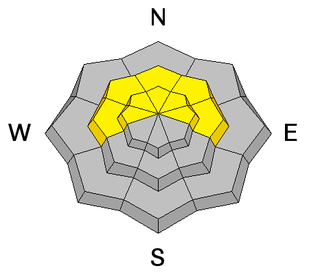
Over the past couple of weeks up to 3' of snow has fallen on top of persistent buried weaknesses in the snowpack. Though the snowpack has largely adjusted to this new load, it is still a delicate balance. We call this a low probability-high consequence situation where the odds of triggering a deep persistent slab are getting slimmer, but the consequences are such that the risk probably isn't worth it. Careful slope analysis is key for those who wish to venture into larger terrain. This danger is most prevalent at upper-mid to upper elevations on slopes steeper than 35 degrees that have a NW-N-E aspect, particularly in areas of rocky terrain that have a thin snowpack. |
 |
weather More snow is on tap for the mountains today with 3-5" possible. Winds will shift to the SW and back off into the 10-15 mph range. High temperatures at 10,000' will be in the low 20's. Friday: Mostly sunny, with a high near 21. East northeast wind 5 to 10 mph becoming south in the afternoon. |
| general announcements
Grooming Conditions: Trails were groomed into Gold Basin on Tuesday but expect fresh snow on top today. Observations: If you are out and about, I would love to know what you are seeing. Please post your observations here. EMAIL ADVISORY If you would like to get the daily advisory by email you will need to subscribe here. Benefit the Utah Avalanche Center when you shop from Backcountry.com or REI: Click this link for Backcountry.com or this link to REI, shop, and they will donate a percent of your purchase price to the UAC. Both offer free shipping (with some conditions) so this costs you nothing! Benefit the Utah Avalanche Center when you buy or sell on ebay - set the Utah Avalanche Center as a favorite non-profit in your ebay account here and click on ebay gives when you buy or sell. You can choose to have your seller fees donated to the UAC, which doesn't cost you a penny. This advisory is from the U.S.D.A. Forest Service, which is solely responsible for its content. This advisory describes general avalanche conditions and local variations always exist. This advisory will be updated on Saturday, January 3 or sooner if conditions warrant. |


_2.jpg)