
| During the month of April, Mark Miller will donate $75 to the charity of your choice (5 to chose from, including the Utah Avalanche Center!) Mark Miller Subaru has raised over $300k in the previous 6 Do Good Feel Good events. More Info here |  |
| During the month of April, Mark Miller will donate $75 to the charity of your choice (5 to chose from, including the Utah Avalanche Center!) Mark Miller Subaru has raised over $300k in the previous 6 Do Good Feel Good events. More Info here | |
| Advisory: Moab Area Mountains | Issued by Eric Trenbeath for Tuesday - December 30, 2014 - 7:30am |
|---|

|
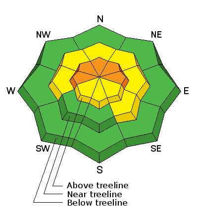
bottom line Today the danger will rise to CONSIDERABLE in upper elevation, wind exposed terrain on slopes steeper than 35 degrees that have a W-N-E aspect. This danger applies to newly formed wind slabs as well as lingering persistent slabs.
|
 |
current conditions Monday's storm delivered 8" of light density powder to the Geyser Pass Trailhead and up to 16" at higher elevations. Southeast winds have been on the increase since about 2:00 a.m. averaging 20 mph and gusting to near 30. With plenty of snow available for transport, sensitive new wind slabs will be developing today on the lee sides of ridges and terrain features in exposed terrain.
It is 0 degrees on Pre Laurel Peak and 9 at the Geyser Pass Trailhead. Mountain weather conditions at 11,700' on Pre-Laurel Peak. Snow totals at Geyser Pass Trailhead. New snow totals in Gold Basin. |
| type | aspect/elevation | characteristics |
|---|

|
|
LIKELIHOOD
 LIKELY
UNLIKELY
SIZE
 LARGE
SMALL
TREND
 INCREASING DANGER
SAME
DECREASING DANGER
|
|
description
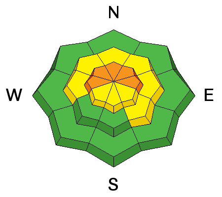
With moderate SE winds, and plenty of light density snow available for transport, there will be a rising danger for newly formed slabs, primarily on wind exposed, upper elevation terrain with a W through NE aspect.Look for smooth rounded deposits of wind drifted snow, and be alert to signs of instability such as cracking in the snow surface or collapsing of the snowpack. |
| type | aspect/elevation | characteristics |
|---|

|
|
LIKELIHOOD
LIKELY
UNLIKELY
SIZE
 LARGE
SMALL
TREND
INCREASING DANGER
SAME
DECREASING DANGER
|
|
description
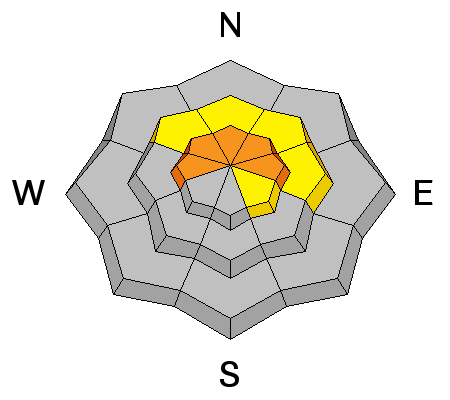
Recent snows and newly formed wind slabs will add stress to the buried weak layers within the snow pack re-awakening the potential for triggering a a deep persistent slab.This danger is most prevalent at upper-mid to upper elevations on slopes steeper than 35 degrees that have a NW-N-E aspect, particularly in areas of rocky terrain that have a thin snowpack. |
 |
weather Mostly cloudy skies and more opportunity for snow will continue through Wednesday. 1-3" is possible today with another 1-3" tonight, and 2-4" tomorrow. High temperatures at 10,000' will be around 15 degrees and winds will be out of the SE at 15-20 mph. |
| general announcements
Grooming Conditions: Trails have been packed out into Gold Basin. Observations: If you are out and about, I would love to know what you are seeing. Please post your observations here. EMAIL ADVISORY If you would like to get the daily advisory by email you will need to subscribe here. Benefit the Utah Avalanche Center when you shop from Backcountry.com or REI: Click this link for Backcountry.com or this link to REI, shop, and they will donate a percent of your purchase price to the UAC. Both offer free shipping (with some conditions) so this costs you nothing! Benefit the Utah Avalanche Center when you buy or sell on ebay - set the Utah Avalanche Center as a favorite non-profit in your ebay account here and click on ebay gives when you buy or sell. You can choose to have your seller fees donated to the UAC, which doesn't cost you a penny. This advisory is from the U.S.D.A. Forest Service, which is solely responsible for its content. This advisory describes general avalanche conditions and local variations always exist. |


_2.jpg)
