
| During the month of April, Mark Miller will donate $75 to the charity of your choice (5 to chose from, including the Utah Avalanche Center!) Mark Miller Subaru has raised over $300k in the previous 6 Do Good Feel Good events. More Info here |  |
| During the month of April, Mark Miller will donate $75 to the charity of your choice (5 to chose from, including the Utah Avalanche Center!) Mark Miller Subaru has raised over $300k in the previous 6 Do Good Feel Good events. More Info here | |
| Advisory: Moab Area Mountains | Issued by Eric Trenbeath for Sunday - December 21, 2014 - 7:03am |
|---|

|
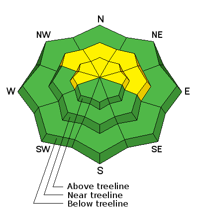
bottom line The avalanche danger is MODERATE today for triggering a recently buried persistent slab on upper elevation terrain steeper than 35 degrees on slopes with a NW-N-E aspect.
|
 |
current conditions The last two days consisted of sunny skies and powder conditions in the La Sal Mountains. Though the pack remains shallow, things have improved remarkably over the past week and people have been venturing into what we can call "ski and riding terrain." Keep in mind however, that the snowpack is still quite shallow, and there are many objects lurking just below the surface that could ruin the rest of your season. The base is 21" at the Geyser Pass Trailhead, and 31" in Gold Basin. Winds continue to be quite behaved alternating between WSW and NW in the 10-15 mph range along ridge tops. Expect them to be on the increase later today and especially by Monday when a powerful storm on a NW flow passes by to the North. It is currently 16 degrees on Pre Laurel Peak and 26 at the Geyser Pass Trailhead. Mountain weather conditions at 11,700' on Pre-Laurel Peak. Snow totals at Geyser Pass Trailhead. New snow totals in Gold Basin. |
| type | aspect/elevation | characteristics |
|---|

|
|
LIKELIHOOD
 LIKELY
UNLIKELY
SIZE
 LARGE
SMALL
TREND
 INCREASING DANGER
SAME
DECREASING DANGER
|
|
description
The snow that fell over the past week has largely settled into place, and we are now back to concerns over the ever present persistent slab. November snow is turning to facets, or weak sugary snow, and we are now starting to get a load on top. In some cases, old stiff slabs overly these facets, and they are now covered by anywhere from 1-2' of new snow. There is also a very weak layer of mid pack faceting associated with a crust. The concern now is triggering a slide on one off these buries weaknesses. You are most likely to encounter this problem on slopes steeper then 35 degrees on upper elevation slopes with a NW-N-E aspect.
Weak, faceted grains at the bottom of the pack. |
 |
weather A powerful Pacific storm system on a northwest flow will pass by to the north later today and into Monday. This will put our area under cloudy skies but with only a slight chance at some snow. Today will be mostly cloudy with high temperatures at 10,000' approaching 30 degrees. Winds will be in the increase tonight and especially into Monday, which looks to be cloudy and blustery. Brief ridging will build on Tuesday before the anticipated Christmas storm moves in off the coast. This looks like it will mostly favor the north central mountains of Colorado, after which we move into a drying trend. Today: A 30 percent chance of snow, mainly after 11am. Mostly cloudy, with a high near 30. West northwest wind 5 to 15 mph. |
| general announcements If you are out and about, I would love to know what you are seeing. Please post your observations here. The road to the Geyser Pass Trailhead is plowed and clear. Thanks to Jesse for fixing the roller. It is back at the Geyser Pass Trailhead and ready for grooming. EMAIL ADVISORY If you would like to get the daily advisory by email you will need to subscribe here. Benefit the Utah Avalanche Center when you shop from Backcountry.com or REI: Click this link for Backcountry.com or this link to REI, shop, and they will donate a percent of your purchase price to the UAC. Both offer free shipping (with some conditions) so this costs you nothing! Benefit the Utah Avalanche Center when you buy or sell on ebay - set the Utah Avalanche Center as a favorite non-profit in your ebay account here and click on ebay gives when you buy or sell. You can choose to have your seller fees donated to the UAC, which doesn't cost you a penny. This advisory is from the U.S.D.A. Forest Service, which is solely responsible for its content. This advisory describes general avalanche conditions and local variations always exist. |


_2.jpg)


