
| During the month of April, Mark Miller will donate $75 to the charity of your choice (5 to chose from, including the Utah Avalanche Center!) Mark Miller Subaru has raised over $300k in the previous 6 Do Good Feel Good events. More Info here |  |
| During the month of April, Mark Miller will donate $75 to the charity of your choice (5 to chose from, including the Utah Avalanche Center!) Mark Miller Subaru has raised over $300k in the previous 6 Do Good Feel Good events. More Info here | |
| Advisory: Moab Area Mountains | Issued by Eric Trenbeath for Sunday - December 14, 2014 - 6:41am |
|---|

|
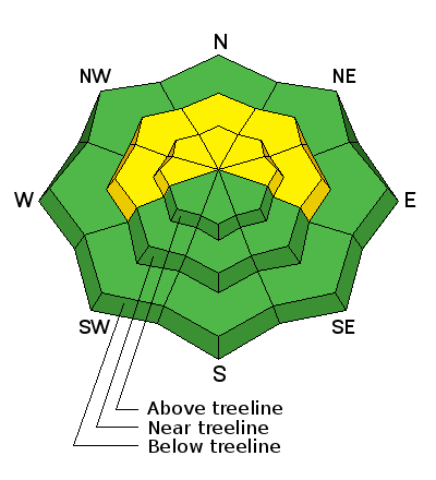
bottom line The avalanche danger is MODERATE today for triggering a recently deposited wind slab on mid-upper elevation terrain steeper than 35 degrees on slopes that have a W-N-E aspect. There is also a MODERATE or isolated danger for triggering a buried persistent slab on upper elevation terrain steeper than 35 degrees on slopes with a NW-N-E aspect.
|
 |
current conditions It was a winter wonderland in the mountains yesterday with snow falling more than an inch an hour at times. Snow started falling around 9:00 a.m. and continued off and on until around 3:00 p.m. leaving us with 7" of new snow at the Geyser Pass Trailhead. Though it is most welcome, the new snow isn't enough to make for green light conditions. The new blanket of fresh powder looks enticing, but it is just enough to cover previously exposed rocks and stumps. Also keep in mind that on many sun and wind exposed slopes, the new snow has fallen on bare ground. Winds during the storm were from the SSW averaging 20-30 mph with gusts near 50 mph. About 5:00 p.m. they backed off shifting to Northwesterly where they hung in the single digits until early this morning. They are currently averaging 10-15 mph from the NNW and the tempearrture at 11,700' is a frigid 9 degrees. It is 24 degrees at the Geyser Pass Trailhead. Mountain weather conditions at 11,700' on Pre-Laurel Peak. Snow totals at Geyser Pass Trailhead. |
| type | aspect/elevation | characteristics |
|---|

|
|
LIKELIHOOD
 LIKELY
UNLIKELY
SIZE
 LARGE
SMALL
TREND
 INCREASING DANGER
SAME
DECREASING DANGER
|
|
description
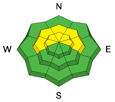
All the ingredients for wind slab development were present yesterday. 7" of new snow combined with moderate to strong SW winds, resulted in new wind slab development on mid to upper elevation wind affected terrain primarily with a W-N--E aspect. Suspect slopes steeper than about 35 degrees, and look for smooth, rounded pillows of recently deposited, wind drifted snow. |
| type | aspect/elevation | characteristics |
|---|

|
|
LIKELIHOOD
 LIKELY
UNLIKELY
SIZE
LARGE
SMALL
TREND
 INCREASING DANGER
SAME
DECREASING DANGER
|
|
description
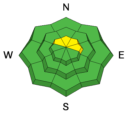
This new load of snow could re-awaken the possibility of triggering an isolated, persistent slab in areas where early season snow has turned to facets, or weak sugary snow that underlies an older stiff slab. The most likely scenario, though isolated, would be to trigger a recently deposited wind slab that then steps down into these older weak layers. This problem will be most pronounced on shady, upper elevation terrain with a NW-N-E aspect. |
 |
weather Lingering clouds and occasional light snow shower activity should remain over the mountains today with partial clearing by this afternoon. Mostly clear skies should prevail on Monday with an unsettled weather pattern in place for next week. Today: Snow showers, mainly before 4pm. Areas of fog before 10am. High near 26. West wind around 10 mph, with gusts as high as 20 mph. Chance of precipitation is 80%. Total daytime snow accumulation of around an inch possible.
|
| general announcements The Geyser Pass Road is now covered with up to 6" of snow and in many cases has a slick smooth surface underneath. Numerous cars made it up yesterday but it has not been plowed and 4wd is a must. Thanks to everyone who came out for the LUNA grooming clinic yesterday! We will post the grooming conditions once the schedule is in place.
|


_2.jpg)