
| During the month of April, Mark Miller will donate $75 to the charity of your choice (5 to chose from, including the Utah Avalanche Center!) Mark Miller Subaru has raised over $300k in the previous 6 Do Good Feel Good events. More Info here |  |
| During the month of April, Mark Miller will donate $75 to the charity of your choice (5 to chose from, including the Utah Avalanche Center!) Mark Miller Subaru has raised over $300k in the previous 6 Do Good Feel Good events. More Info here | |
| Advisory: Moab Area Mountains | Issued by Eric Trenbeath for Wednesday - April 2, 2014 - 7:16am |
|---|


|
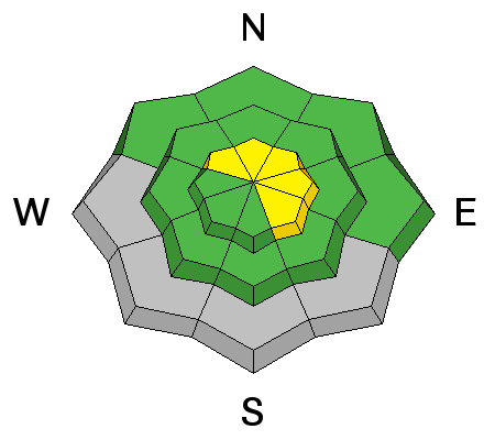
bottom line The Avalanche danger is MODERATE today, primarily at upper elevations in areas where you can detect recent deposits of wind drifted snow. At mid and lower elevations, the avalanche danger is generally LOW.
|
 |
current conditions La Sal Mountains I woke up to the sound of rain on the roof this morning which has translated to 2" of new snow in the mountains. 1-3" are possible today with another 2-4" tonight. South winds have been on the increase since about 2 this morning and they are currently blowing 30-40 mph on Pre Laurel Peak. They will shift to the NW by tonight. It is currently 19 degrees at 10,000'. Winds and temperature on Pre-Laurel Peak (11,705') Temperature and new snow totals in Gold Basin (10,050') Total snow depth and temperature near Geyser Pass Trailhead (9850') Abajo Mountains We are through issuing information on conditions in the Abajo Mountains. You can get current weather and snow pack data on the links below. Winds and temperature on Abajo Peak. Snow totals at Camp Jackson (8968') |
| type | aspect/elevation | characteristics |
|---|

|
|
LIKELIHOOD
 LIKELY
UNLIKELY
SIZE
 LARGE
SMALL
TREND
 INCREASING DANGER
SAME
DECREASING DANGER
|
|
description
With more snow in the forecast, and with windy conditions up high, you will need to be alert to fresh deposits of wind drifted snow on the lee sides of ridge crests and terrain features, mostly at upper elevations. These new slabs should be mostly small, shallow, and manageable, but it all depends on how much snow we get. Be alert to signs of cracking and look for smooth rounded pillows of recently deposited, wind drifted snow. Expect the danger to rise if significant amounts of snow materialize. |
 |
weather A split Pacific Storm System will affect our area today through Thursday. 1-3" of snow are possible in the mountains today, with another 2-4" possible tonight. Daytime high temperatures for the next couple of days will be in the mid 30's. S winds will shift to NW by Wednesday night, averaging 15 mph with higher gusts along ridge tops.Friday looks to be mostly sunny with high temperatures climbing into the mid 40's. |
| general announcements OBSERVATIONS: If you are out and about in the mountains, I'd love to know what you are seeing so please SUBMIT OBSERVATIONS You can read current OBSERVATIONS HERE. ROAD CONDITIONS: Expect to find a couple inches of new snow on top of mostly dirt. UAC MOBILE APP: Get your advisory on your iphone with this app
|


_2.jpg)