
| During the month of April, Mark Miller will donate $75 to the charity of your choice (5 to chose from, including the Utah Avalanche Center!) Mark Miller Subaru has raised over $300k in the previous 6 Do Good Feel Good events. More Info here |  |
| During the month of April, Mark Miller will donate $75 to the charity of your choice (5 to chose from, including the Utah Avalanche Center!) Mark Miller Subaru has raised over $300k in the previous 6 Do Good Feel Good events. More Info here | |
| Advisory: Moab Area Mountains | Issued by Eric Trenbeath for Monday - March 31, 2014 - 7:03am |
|---|

|
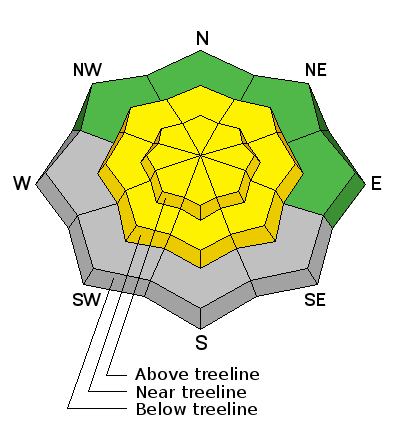
bottom line The Avalanche danger is MODERATE. You will need to be aware of two distinct dangers: 1) recent deposits of wind drifted snow, primarily on steep slopes at upper elevations, and 2) wet slide activity on sun exposed slopes as the day heats up.
|
 |
special announcement I will update this advisory twice a week for the remainder of the season unless conditions change. This advisory is generated from field work on Sunday, March 30, and weather observations received Monday, March 31, at 6:00 a.m. The next advisory will be posted on Friday, Aprril 4th. |
 |
current conditions La Sal Mountains The story has been the wind, and the sun, and did I mention the wind? Winds howled on Sunday. Mostly southerly, they veered from SW to SE, averaging 30 mph along ridge tops and gusting to near 70. They backed off by Monday morning averaging 10 mph from the NW. On Saturday, a strong sun and temperatures in the 50's put a crust over nearly everything up to about 10,500', as a result, there wasn't a lot of snow available for transport except at the upper elevations, but there was a fair amount of it moving around up there on Sunday. The snow pack is deteriorating rapidly, and many sun and wind exposed slopes are already stripped to bare ground. Unsettled weather for the week will prevent a corn cycle from happening, but there is a chance for snow midweek. Winds and temperature on Pre-Laurel Peak (11,705') Temperature and new snow totals in Gold Basin (10,050') Total snow depth and temperature near Geyser Pass Trailhead (9850') Abajo Mountains We are through issuing information on conditions in the Abajo Mountains. You can get current weather and snow pack data on the links below. Winds and temperature on Abajo Peak. Snow totals at Camp Jackson (8968') |
| type | aspect/elevation | characteristics |
|---|

|
|
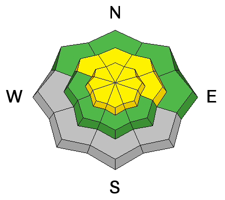
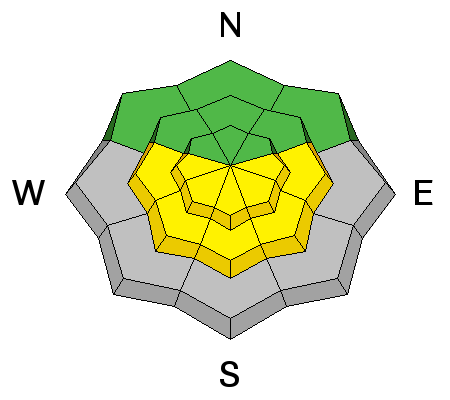
LIKELIHOOD
 LIKELY
UNLIKELY
SIZE
 LARGE
SMALL
TREND
 INCREASING DANGER
SAME
DECREASING DANGER
|
|
description
Strong winds moved snow around on Sunday, and you will need to be aware of recently deposited wind slabs on all aspects at upper elevations on the lee sides of ridge crests and terrain features. Many of these slabs will be stiff, or hard and supportable, and they may be disguised by wind etching or scouring, so be alert to anything that feels or sounds hollow underneath. With forecasted windy conditions all week, this problem will persist. |
| type | aspect/elevation | characteristics |
|---|

|
|
LIKELIHOOD
LIKELY
UNLIKELY
SIZE
LARGE
SMALL
TREND
INCREASING DANGER
SAME
DECREASING DANGER
|
|
description
Unsettled weather for the week will keep the mountains under partly to mostly cloudy skies, with the exception being on Monday. Nevertheless, high temperatures are expected to be in the mid 40's, and it won't take much to heat up the snow if the sun does poke out. For this reason, it will be necessary to maintain awareness for wet slide activity on all sun exposed slopes. |
 |
weather
|
| general announcements OBSERVATIONS: If you are out and about in the mountains, I'd love to know what you are seeing so please SUBMIT OBSERVATIONS You can read current OBSERVATIONS HERE. ROAD CONDITIONS: The road is mostly dry and passable. UAC MOBILE APP: Get your advisory on your iphone with this app
|


_2.jpg)
