
| During the month of April, Mark Miller will donate $75 to the charity of your choice (5 to chose from, including the Utah Avalanche Center!) Mark Miller Subaru has raised over $300k in the previous 6 Do Good Feel Good events. More Info here |  |
| During the month of April, Mark Miller will donate $75 to the charity of your choice (5 to chose from, including the Utah Avalanche Center!) Mark Miller Subaru has raised over $300k in the previous 6 Do Good Feel Good events. More Info here | |
| Advisory: Moab Area Mountains | Issued by Eric Trenbeath for Saturday - March 22, 2014 - 4:00pm |
|---|

|
bottom line The Avalanche danger is generally LOW at this time, but as always, low danger doesn't mean no danger. It is important to maintain general avalanche awareness as it pertains to the problems of 1) recently deposited wind slabs in exposed, upper elevation terrain, 2) buried persistent slabs in areas that have the weakest snow pack, 3) loose, wet avalanches during periods of daytime heating.
|
 |
special announcement This advisory will be updated twice weekly for the remainder of our operating season unless significant changes occur. This advisory was updated at 4:00 p.m. on Saturday, March 22. The next advisory will be posted on Tuesday, March 25. |
 |
current conditions La Sal Mountains The lion of March has roared mostly in the form of wind this month. Snow totals have barely amounted to a whimper, and the snow pack has slipped to 68% of normal. 2" of new snow fell in the mountains on Saturday, but this will hinder, rather than help conditions in the short term meaning that corn will not be happening on Sunday. In general, the snow surface has taken quite a hit this month from the wind and sun, and many exposed slopes are showing bare ground. Best hope for decent turning conditions are on very sheltered, upper elevation, northerly aspects. Corn-like conditions may return by Monday or Tuesday, on mid elevation southerly aspects that still have snow on them. But you will need a good overnight freeze, and a warm, sunny day to take advantage of them. Winds and temperature on Pre-Laurel Peak (11,705') Temperature and new snow totals in Gold Basin (10,050') Total snow depth and temperature near Geyser Pass Trailhead (9850') Abajo Mountains A trip around the Abajos on Wednesday painted an even grimmer picture. The entire south side of the range is bone dry, and lower elevations on all aspects are going fast. In spite of their grim appearance however, the Abajos are neck and neck with the La Sals now at 60% of average snow pack. Winds and temperature on Abajo Peak. Snow totals at Camp Jackson (8968') |
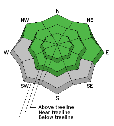
| type | aspect/elevation | characteristics |
|---|

|
|
LIKELIHOOD
 LIKELY
UNLIKELY
SIZE
 LARGE
SMALL
TREND
 INCREASING DANGER
SAME
DECREASING DANGER
|
|
description
The Avalanche Danger is generally low at this time, but remember that low danger doesn't mean no danger. Normal caution and avalanche awareness need to be maintained against the following potential dangers: 1) Persistent Slab: It has been 3 weeks since the last large, persistent slab avalanche occurred. Nevertheless, areas of weak snow with an overlying slab may still exist. Areas of weakest snow can be found in steep, rocky, or slightly wooded terrain, facing the north half of the compass, at upper mid to upper elevations. Or right around tree line. I would still exercise caution in these areas. 2) Wind Slab: Always maintain awareness of recent deposits of wind drifted snow on the lee sides of ridge crests or terrain features. Look for characteristic smooth, rounded pillows, or areas that have a hollow feel to them. 3) Loose, Wet Avalanches: Be alert to the danger for wet slide activity as the days heat up. Be on the look out for the usual signs of instability, such as roller balls, pinwheels, and of course, loose sluffs. If you notice any of these signs, or find yourself sinking in to sloppy snow, it is time to get off of and out from under steep slopes. |
 |
weather Look for sunny skies and a general warming trend over the next several days. A cold front and weak system, mainly affecting areas to the north, is being advertised for Thursday. Expect winds to pick up Tuesday night and Wednesday ahead of this.
|
| general announcements OBSERVATIONS: If you are out and about in the mountains, I'd love to know what you are seeing so please SUBMIT OBSERVATIONS You can read current OBSERVATIONS HERE. ROAD CONDITIONS: The road is passable but a bit rugged. The lower part is dry, and then it alternates between patches of dry ground, snow ruts, and packed snow and ice that gets sloppy late in the day. UAC MOBILE APP: Get your advisory on your iphone with this app
|


_2.jpg)
