
| During the month of April, Mark Miller will donate $75 to the charity of your choice (5 to chose from, including the Utah Avalanche Center!) Mark Miller Subaru has raised over $300k in the previous 6 Do Good Feel Good events. More Info here |  |
| During the month of April, Mark Miller will donate $75 to the charity of your choice (5 to chose from, including the Utah Avalanche Center!) Mark Miller Subaru has raised over $300k in the previous 6 Do Good Feel Good events. More Info here | |
| Advisory: Moab Area Mountains | Issued by Eric Trenbeath for Tuesday - March 18, 2014 - 7:30am |
|---|

|
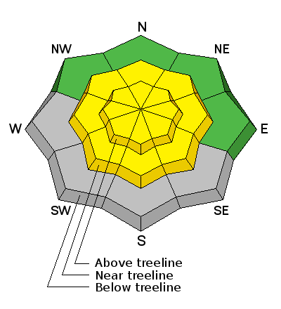
bottom line Today there will be a MODERATE danger on slopes steeper than 35 degrees, primarily at upper elevations, where you can detect recent deposits of wind drifted snow. There also remains a MODERATE danger of triggering a deep, buried, persistent slab on mid to upper elevation slopes, steeper than 35 degrees that face the north half of the compass. There will also be a MODERATE danger for wet slide activity, primarily on sun exposed slopes as the day heats up.
|
 |
special announcement This advisory will be updated twice weekly unless significant changes occur in the weather forecast. The next advisory will be updated on Saturday, March 22, or sooner if conditions warrant. |
 |
current conditions La Sal Mountains Winds averaging 30-40 mph blew most of the day on Monday, starting out from the SW and shifting to the NW before backing off into the single digits by Tuesday morning. Overnight lows on Monday were very cold, in the single digits, and they are forecasted to be in the low 20's for the remainder of the week. High temperatures are expected to be in the low to mid 30's. The snow surface has taken a beating in exposed areas, particularly in the upper elevations, and some slopes are scoured to near the ground. On sheltered, mid-elevation south and west facing slopes, corn like conditions may be found. Winds and temperature on Pre-Laurel Peak (11,705') Temperature and new snow totals in Gold Basin (10,050') Total snow depth and temperature near Geyser Pass Trailhead (9850') Abajo Mountains Continued low snow, and spring like snow conditions reign over the Abajo Mountains. Many slopes with S-E-SW aspects are already melted off down to the ground. Winds and temperature on Abajo Peak. Snow totals at Camp Jackson (8968') |
| type | aspect/elevation | characteristics |
|---|

|
|
LIKELIHOOD
 LIKELY
UNLIKELY
SIZE
 LARGE
SMALL
TREND
 INCREASING DANGER
SAME
DECREASING DANGER
|
|
description
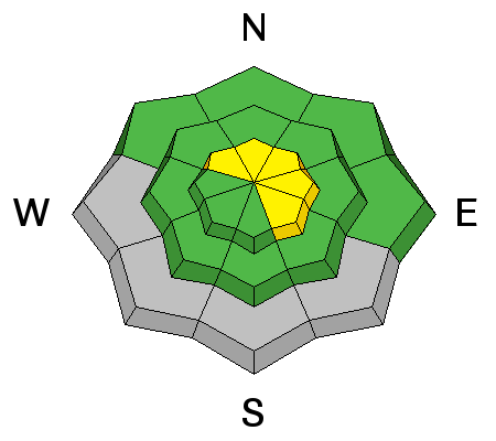
Winds on Monday will have moved around what little snow was available for transport. As a result, there may be some stiff, shallow wind slabs at upper elevations along the lee sides of ridge crests and terrain features. They should be small and manageable, but could possibly knock you off your feet in more extreme terrain. Shifting wind directions will make them possible on slopes facing NW-NE-SE. |
| type | aspect/elevation | characteristics |
|---|

|
|
LIKELIHOOD
LIKELY
UNLIKELY
SIZE
 LARGE
SMALL
TREND
INCREASING DANGER
SAME
DECREASING DANGER
|
|
description
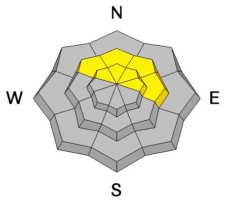
The danger of triggering a persistent slab has become very isolated, though It still may be possible to trigger one in areas that have the weakest snow. Areas of weakest snow can be found in steep, rocky, or slightly wooded terrain, facing the north half of the compass, at upper mid to upper elevations. Or right around tree line. I would still exercise caution in these areas. |
| type | aspect/elevation | characteristics |
|---|

|
|
LIKELIHOOD
LIKELY
UNLIKELY
SIZE
LARGE
SMALL
TREND
 INCREASING DANGER
SAME
DECREASING DANGER
|
|
description
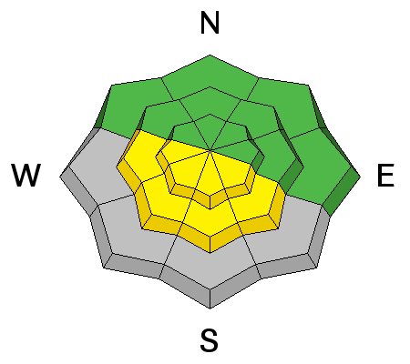
The snow is locking up tight from solid, overnight freezes, and temperatures during the day are not exceedingly warm, but the sun is high and strong this time of year. Be alert to the danger for wet slide activity as the days heat up. Be on the look out for the usual signs of instability, such as roller balls, pinwheels, and of course, loose sluffs. If you notice any of these signs, or find yourself sinking in to sloppy snow, it is time to get off of and out from under steep slopes.
|
 |
weather
|
| general announcements OBSERVATIONS: If you are out and about in the mountains, I'd love to know what you are seeing so please SUBMIT OBSERVATIONS You can read current OBSERVATIONS HERE. LUNA GROOMING INFORMATION: The road into Gold Basin was groomed on Friday afternoon. ROAD CONDITIONS: The road is passable, alternating between patches of dry ground, packed snow and ice that gets sloppy late in the day. UAC MOBILE APP: Get your advisory on your iphone with this app
|


_2.jpg)