
| During the month of April, Mark Miller will donate $75 to the charity of your choice (5 to chose from, including the Utah Avalanche Center!) Mark Miller Subaru has raised over $300k in the previous 6 Do Good Feel Good events. More Info here |  |
| During the month of April, Mark Miller will donate $75 to the charity of your choice (5 to chose from, including the Utah Avalanche Center!) Mark Miller Subaru has raised over $300k in the previous 6 Do Good Feel Good events. More Info here | |
| Advisory: Moab Area Mountains | Issued by Eric Trenbeath for Sunday - March 16, 2014 - 7:28am |
|---|

|
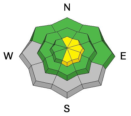
bottom line Today there will be a MODERATE danger on slopes steeper than 35 degrees, primarily at upper elevations, where you can detect recent deposits of wind drifted snow. There also remains a MODERATE danger of triggering a deep, buried, persistent slab on mid to upper elevation slopes, steeper than 35 degrees that face the north half of the compass. There will also be a MODERATE danger for wet slide activity, primarily on sun exposed slopes as the day heats up.
|
 |
current conditions La Sal Mountains Winds continue to blow on Pre Laurel this morning, averaging 20 mph from the NE. And it is cold up there, 16 degrees. But it will be a scorcher, with a high today expected to be around 45 degrees! It appears as though we had a very light dusting, less than half an inch, and I think it may be possible to find corn like conditions today on mid elevation, southerly aspects. Expect to find wind damaged snow on exposed northerly aspects, with soft snow remaining in only the most sheltered areas. Winds and temperature on Pre-Laurel Peak (11,705') Temperature and new snow totals in Gold Basin (10,050') Total snow depth and temperature near Geyser Pass Trailhead (9850') Abajo Mountains Continued low snow, and spring like snow conditions reign over the Abajo Mountains. Many slopes with S-E-SW aspects are already melted off down to the ground. Winds and temperature on Abajo Peak. Snow totals at Camp Jackson (8968') |
| type | aspect/elevation | characteristics |
|---|

|
|
LIKELIHOOD
 LIKELY
UNLIKELY
SIZE
 LARGE
SMALL
TREND
 INCREASING DANGER
SAME
DECREASING DANGER
|
|
description
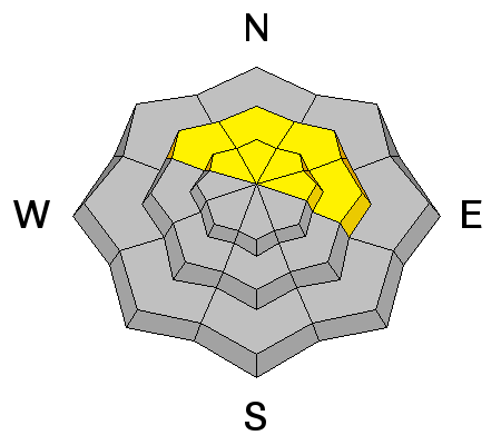
Yesterdays winds moved around what little snow was available for transport. As a result, there may be some stiff, shallow wind slabs at upper elevations along the lee sides of ridge crests and terrain features. They should be small and manageable, but could possibly knock you off your feet in more extreme terrain. |
| type | aspect/elevation | characteristics |
|---|

|
|
LIKELIHOOD
LIKELY
UNLIKELY
SIZE
 LARGE
SMALL
TREND
 INCREASING DANGER
SAME
DECREASING DANGER
|
|
description
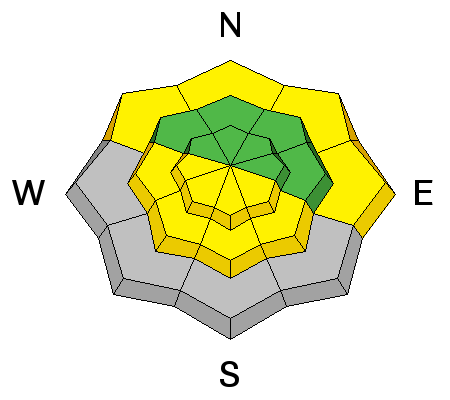
The danger of triggering a persistent slab has become very isolated, though It still may be possible to trigger one in areas that have the weakest snow. Areas of weakest snow can be found in steep, rocky, or slightly wooded terrain, facing the north half of the compass, at upper mid to upper elevations. Or right around tree line. I would still exercise caution in these areas. |
| type | aspect/elevation | characteristics |
|---|

|
|
LIKELIHOOD
 LIKELY
UNLIKELY
SIZE
LARGE
SMALL
TREND
INCREASING DANGER
SAME
DECREASING DANGER
|
|
description
With temperatures in the 40's today, the danger for wet slide activity will be on the rise as the day heats up. Be on the look out for the usual signs of instability, such as roller balls, pinwheels, and of course, loose sluffs. If you notice any of these signs, or find yourself sinking in to sloppy snow, it is time to get off of and out from under steep slopes.
|
 |
weather Today, look for sunny skies and very warm temperatures near 45 degrees. North winds will continue at 10-15 mph. A slight disturbance looks like it will affect our area Monday into Tuesday with clouds and a slight chance for rain and or snow. |
| general announcements OBSERVATIONS: If you are out and about in the mountains, I'd love to know what you are seeing so please SUBMIT OBSERVATIONS You can read current OBSERVATIONS HERE. LUNA GROOMING INFORMATION: The road into Gold Basin was groomed on Friday afternoon. ROAD CONDITIONS: The road is passable, alternating between patches of dry ground, packed snow and ice that gets sloppy late in the day. UAC MOBILE APP: Get your advisory on your iphone with this app
|


_2.jpg)