| During the month of April, Mark Miller will donate $75 to the charity of your choice (5 to chose from, including the Utah Avalanche Center!) Mark Miller Subaru has raised over $300k in the previous 6 Do Good Feel Good events. More Info here |  |
| During the month of April, Mark Miller will donate $75 to the charity of your choice (5 to chose from, including the Utah Avalanche Center!) Mark Miller Subaru has raised over $300k in the previous 6 Do Good Feel Good events. More Info here | |
| Advisory: Moab Area Mountains | Issued by Eric Trenbeath for Saturday - March 8, 2014 - 7:19am |
|---|


|
bottom line The overall avalanche danger is MODERATE at this time. This danger applies to shallow, recently deposited wind slabs, primarily at upper elevations where you can detect recent deposits of wind drifted snow. There also remains a MODERATE danger of triggering a deep, buried, persistent slab on mid to upper elevation slopes, steeper than 35 degrees that face NW-E-SE. And, as daytime heating progresses, there will also be a MODERATE danger for wet slide activity, primarily on sun exposed slopes.
|
 |
special avalanche bulletin
|
 |
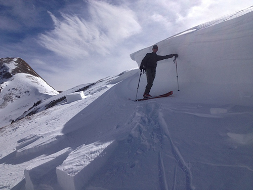
current conditions La Sal Mountains In an amazingly intense flurry, the La Sals picked up 4" in about 3 hours yesterday greatly improving turning and riding conditions. Up to 6" fell in select locations. It is that time of year however, and a strong sun put the hurt on exposed surfaces. Today, good powder will still be found in sheltered areas, but take your glop stopper to gaurd against skin build up, and wax your skis. Ridge top, northerly winds averaged 20 mph overnight, and as of 6 a.m. this morning they are blowing 30-40 mph from the NE on Pre Laurel Peak. If not confined to this elevation, they will have affected the new snow in exposed, upper elevation bowls. It is currently 18 degrees at 10,000'. Winds and temperature on Pre-Laurel Peak (11,705') Temperature and new snow totals in Gold Basin (10,050') Total snow depth and temperature near Geyser Pass Trailhead (9850') Abajo Mountains Winds on Abajo Peak are averaging 10-20 mph from the NW, and the temperature at Buckboard Flat is 30 degrees. Snow last weekend improved conditions a bit but we are playing a difficult game of catch up this late in the season. Snow totals at Camp Jackson (8968') |
 |
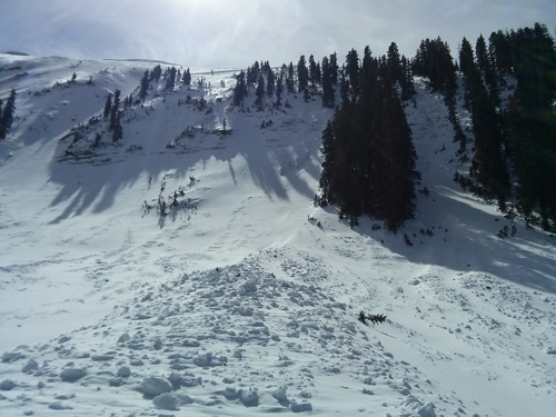
recent activity This is old news in avalanche world, but I got up Thursday to look at the Coyote Chute slide that was reported last Sunday. It turned out to be significantly larger than reported, as it wrapped around the ridge and out of sight. I estimate it to be about 800' wide with a maximum crown depth of 8'. It was caused by wind loading that finally over stressed buried weak layers underneath. this was an old snow avalanche, bringing home everything we say about buried persistent slabs, and the possibility of them being triggered by an over riding wind slab.
|
| type | aspect/elevation | characteristics |
|---|

|

|
LIKELIHOOD
 LIKELY
UNLIKELY
SIZE
 LARGE
SMALL
TREND
 INCREASING DANGER
SAME
DECREASING DANGER
|
|
description
With moderate to strong winds the past few hours, and with 4"-6" of new snow available for transport, you will need to be on the lookout for shallow, recently deposited wind slabs, especially at upper elevations. They will be mostly manageable, but could knock you off your feet and carry you over a rock band, or take you for a ride down a chute or gully. Look for smooth rounded pillows of recently deposited snow on the lee sides of ridges and terrain features. |
| type | aspect/elevation | characteristics |
|---|

|

|
LIKELIHOOD
LIKELY
UNLIKELY
SIZE
 LARGE
SMALL
TREND
 INCREASING DANGER
SAME
DECREASING DANGER
|
|
description
With warmer temperatures and a strong sun, you will need to be alert to wet slide activity as the day progresses. Look for signs of instability such as sloppy wet snow, loose sluffs, and roller balls, or pin wheels coming down the mountain. If any of these signs are present, it is time to stay off of and out from under steep, sun exposed slopes. Wet avalanches may also be possible on northerly aspects at lower elevations. |
| type | aspect/elevation | characteristics |
|---|

|

|
LIKELIHOOD
LIKELY
UNLIKELY
SIZE
 LARGE
SMALL
TREND
 INCREASING DANGER
SAME
DECREASING DANGER
|
|
description
The snow pack has had time to adjust to the most recent load. Nevertheless, there is plenty of weak snow under there. In the right place, the added weight of a skier or rider, could be just enough to tip the balance causing a deep and dangerous avalanche. Areas of weakest snow can be found in steep, rocky, or slightly wooded terrain, facing the north half of the compass, at upper mid to upper elevations. I would still exercise caution in these areas.
|
 |
weather Today, look for sunny skies with high temperatures at 10,000' to be in the low 30's. NE winds will average 10-15 mph. Tomorrow will be sunny and warmer, near 38 degrees at 10,000'. |
| general announcements OBSERVATIONS: If you are out and about in the mountains, I'd love to know what you are seeing so please SUBMIT OBSERVATIONS You can read current OBSERVATIONS HERE. LUNA GROOMING INFORMATION: All trails were packed in with the roller yesterday. ROAD CONDITIONS: The road has not been plowed and there is 4" of snow on it. Several vehicles traveled it yesterday however. UAC MOBILE APP: Get your advisory on your iphone with this app
|


_2.jpg)