| During the month of April, Mark Miller will donate $75 to the charity of your choice (5 to chose from, including the Utah Avalanche Center!) Mark Miller Subaru has raised over $300k in the previous 6 Do Good Feel Good events. More Info here |  |
| During the month of April, Mark Miller will donate $75 to the charity of your choice (5 to chose from, including the Utah Avalanche Center!) Mark Miller Subaru has raised over $300k in the previous 6 Do Good Feel Good events. More Info here | |
| Advisory: Moab Area Mountains | Issued by Eric Trenbeath for Saturday - February 15, 2014 - 7:38am |
|---|


|
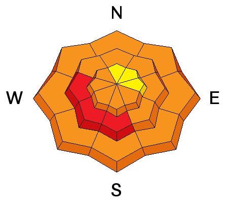
bottom line The avalanche danger will rise to HIGH today as daytime heating increases the danger for wet slide activity. This danger is possible on all aspects but will be primarily found on mid elevation S-W facing slopes. There is also a CONSIDERABLE avalanche danger on slopes steeper than 35 degrees that have recent deposits of wind drifted snow. This danger is primarily located on, but not limited to, mid to upper elevation slopes with N-E-SE aspects. Considerable danger means that natural avalanches are possible and human triggered avalanches are likely. There is also a CONSIDERABLE danger for triggering a buried persistent slab. Back country travelers will need to practice safe travel techniques, staying off of, and out from under steep terrain.
|
 |
special avalanche bulletin Dangerous avalanche conditions exist in the mountains of SE Utah. Warm temperatures with no overnight re-freeze have caused the danger for wet slide activity to rise dramatically. In addition, sustained westerly winds through the week have continued to move snow around causing deep drifts on leeward slopes, primarily at upper elevations. The additional load is adding a lot of stress to the underlying, weak snow pack, and numerous natural avalanches ran last weekend. Slopes that haven't run are hanging in a tenuous balance, further stressed by continued wind loading. Back country travelers need to travel with extreme caution, staying off of and well out from under steep, avalanche terrain. |
 |
current conditions La Sal Mountains Conditions have gotten sloppy out there, particularly at lower to mid elevations where warm daytime temperatures and the lack of an overnight freeze has turned the snow pack into an un easy combination of wet snow, wet snow on facets. Upper elevations hold some dry snow on shady aspects. Overnight winds have shifted from northwesterly to southwesterly but continue to average in the 20's with gusting into the 30's.Temperatures remained in the mid 30's overnight at 10,000'. There is 51" of snow on the ground in Gold Basin, and 31" at the Geyser Pass Trailhead. Winds and temperature on Pre-Laurel Peak (11,705') Temperature and new snow totals in Gold Basin (10,050') Total snow depth and temperature near Geyser Pass Trailhead (9850') Abajo Mountains Low snow conditions still remain in the Abajo Mountains with lower elevations turning into a soupy mess of wet snow on facets. Winds on Abajo Peak have been strong overnight, averaging 25 mph and gusting to 50. It is currently 34 degrees. Winds and temperature on Abajo Peak (11,330') Snow totals at Camp Jackson (8968') |
| type | aspect/elevation | characteristics |
|---|

|

|
LIKELIHOOD
 LIKELY
UNLIKELY
SIZE
 LARGE
SMALL
TREND
 INCREASING DANGER
SAME
DECREASING DANGER
|
|
description
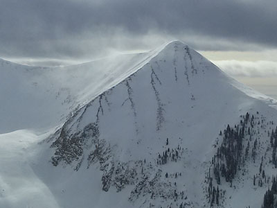
Steady, moderate, westerly winds continue to load easterly aspects at upper elevations, and dangerous wind slab conditions exist. Drifts up to three feet deep can be found, and they are connecting across wide areas. Triggering one of these slabs would be dangerous enough, but they also wield the potential to step down deeper into the snow pack causing a large, and possibly un-survivable avalanche. The following photo illustrates persistent wind loading:
|
| type | aspect/elevation | characteristics |
|---|

|
|
LIKELIHOOD
 LIKELY
UNLIKELY
SIZE
 LARGE
SMALL
TREND
INCREASING DANGER
SAME
DECREASING DANGER
|
|
description
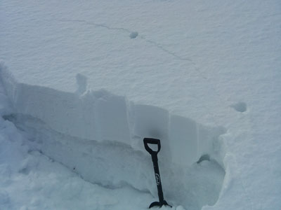
Snow stability tests continue to indicate that the new snow weight is dangerously close to affecting buried, persistent weak layers in the snow pack. Currently, all that is needed to trigger a large avalanche into deeper, old snow is a significant trigger. This could easily be you. In addition, steady winds have continued to ll transport significant amounts of snow, adding further weight and stress to these buried weak layers. It is a very delicate balance out there right now, and the possibility of triggering a deep, persistent slab is a very real and present danger. Photo illustrates cracking in the snow of the past 10 days that has consolidated over top of very weak snow.
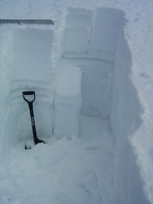
Snow pit illustrates weak layers in the snow pack with a very clean shear on mid level facets. CT12 Q3
|
| type | aspect/elevation | characteristics |
|---|

|
|
LIKELIHOOD
 LIKELY
UNLIKELY
SIZE
LARGE
SMALL
TREND
 INCREASING DANGER
SAME
DECREASING DANGER
|
|
description
With the lack of an overnight freeze, and with forecasted temperatures to rise into the 40's today, the likelihood of wet slide activity exists on all aspects. This danger will rise to high on slopes with southerly aspects as daytime heating progresses. Stay of of and out form under steep slopes and be alert to signs of instability such as roller balls, wet sluffs, and soft, sloppy snow up over your boot tops. |
 |
weather It is going to be warm up there today with forecasted high temperatures of around 45 degrees at 10,000'. Skies will be partly sunny with light SW winds. |
| general announcements OBSERVATIONS: If you are out and about in the mountains, I'd love to know what you are seeing so please SUBMIT OBSERVATIONS You can read current OBSERVATIONS HERE. LUNA GROOMING INFORMATION: Trails are groomed and are in excellent shape. Get on them on the morning for fastest conditions. ROAD CONDITIONS: The road is snow packed but clear. UAC MOBILE APP: Get your advisory on your iphone with this app
|


_2.jpg)