
| During the month of April, Mark Miller will donate $75 to the charity of your choice (5 to chose from, including the Utah Avalanche Center!) Mark Miller Subaru has raised over $300k in the previous 6 Do Good Feel Good events. More Info here |  |
| During the month of April, Mark Miller will donate $75 to the charity of your choice (5 to chose from, including the Utah Avalanche Center!) Mark Miller Subaru has raised over $300k in the previous 6 Do Good Feel Good events. More Info here | |
| Advisory: Moab Area Mountains | Issued by Eric Trenbeath for Tuesday - February 4, 2014 - 6:29am |
|---|


|
bottom line There is a HIGH avalanche danger in the wind zone at upper elevations, on slopes steeper than 35 degrees, that face N-NE-E, that have recent deposits of wind drifted snow. Back country travel is not recommended in these areas. The avalanche danger is CONSIDERABLE on all other slopes steeper than 35 degrees that have recent deposits of wind drifted snow. Loose snow sluffs are also likely. Considerable danger means that natural avalanches are possible and human triggered avalanches are likely. Back country travelers will need to practice very safe travel techniques, staying off of, and out from under steep terrain.
|
 |
special avalanche bulletin We are in the thick of a heavy winter storm. Snow fall totals in the last 24 hours in the La Sal Mountains have been about 15", and another 5"-9" is possible today. Water weight from this storm has not been significant, less than 1", Nevertheless, there is a lot of new snow out there to blow around. New snow avalanches are probable and it could be possible to trigger a much deeper avalanche into older weak snow. Back country travelers today will have to use extra caution in navigating avalanche terrain. Stay off of, and out from under slopes steeper than 35 degrees and give run out zones a wide berth. |
 |
current conditions La Sal Mountains Wow! Where did that come from? Yesterday's forecasted 2"-4" turned into about 10" during the day, and another 5" of light density snow has fallen over night. Expect deep, light, powder conditions in the mountains today with another 5"-9" possible. Ridge top winds yesterday averaged in the teens, with gusts near 30 mph from the SSW. They backed off into the single digits over night and have shifted to more more westerly. As of 5 a.m. they were averaging 10 mph and gusting into the low 20's. It is currently 11 degrees at 10,000; and and 4 degrees on Pre-Laurel Peak. Winds and temperature on Pre-Laurel Peak (11,705') Temperature and new snow totals in Gold Basin (10,050') Total snow depth and temperature near Geyser Pass Trailhead (9850') Abajo Mountains Snow data from the Abajos is sketchy this morning with blank spaces appearing on the chart and an overall report of only 4" at Camp Jackson and maybe 6" at Buckboard Flat. I have to think they've gotten more, so we will have to wait for an on the ground report. Winds on Abajo Peak have been remarkably well behaved, hovering in the single digits and gusting into the teens from the WSW. The temperature up there this morning is a frigid 4 degrees. Winds and temperature on Abajo Peak (11,330') Snow totals at Camp Jackson (8968') |
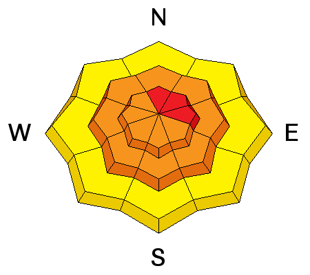
| type | aspect/elevation | characteristics |
|---|

|
|
LIKELIHOOD
 LIKELY
UNLIKELY
SIZE
 LARGE
SMALL
TREND
 INCREASING DANGER
SAME
DECREASING DANGER
|
|
description
With 15" of new snow already on the ground at mid elevations, and with more in the forecast, it will be possible to trigger avalanches in the new snow up to 2' or more in depth. Winds have been mostly light below tree line and much of the avalanching will occur as loose sluffs, or extremely soft, sensitive slabs. This danger will rise above tree line where ridge top winds have blown just hard enough to move some snow around. Expect to find sensitive wind drifts at upper elevations, particularly on slopes with N-NE aspects where dangerous slabs up to 30" deep or more may be found. In addition, an avalanche triggered in the new snow in these areas will have a high potential for stepping down into deeper, weak layers, causing a larger, and even more dangerous avalanche.
|
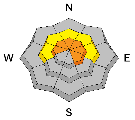
| type | aspect/elevation | characteristics |
|---|

|
|
LIKELIHOOD
LIKELY
UNLIKELY
SIZE
 LARGE
SMALL
TREND
INCREASING DANGER
SAME
DECREASING DANGER
|
|
description
The underlying snow pack being asked to bare an additional load of new snow is very weak. In spite of significant snow totals however, actual water weight is very little. This makes for a touchy situation out there. Not quite enough of a load has accumulated to trigger a widespread natural avalanche cycle, but a back country traveler will have a considerable likelihood of triggering one of these avalanches themselves. This would be a large and dangerous avalanche, and slopes steeper than 35 degrees with a NW-N-E aspect are to be avoided.
|
 |
weather Snow is forecasted to continue today with another 5"-9" of very light density snow possible. Winds will be from the WNW, averaging 10 mph along ridge tops, and the high for today at 10,000' will be around 13 degrees. A chance of snow will linger into tonight with an unsettled weather pattern for the rest of the week. Looks like we'll get another shot at snow on Friday. |
| general announcements OBSERVATIONS: If you are out and about in the mountains, I'd love to know what you are seeing so please SUBMIT OBSERVATIONS You can read current OBSERVATIONS HERE. LUNA GROOMING INFORMATION: Deep powder snow covers the trails.. ROAD CONDITIONS: Plow crews were up yesterday but their work has been obliterated. The new snow is light and fell without much wind at lower elevations, and the intrepid with 4wd shouldn't have a problem getting up there. UAC MOBILE APP: Get your advisory on your iphone with this app
|


_2.jpg)
