| During the month of April, Mark Miller will donate $75 to the charity of your choice (5 to chose from, including the Utah Avalanche Center!) Mark Miller Subaru has raised over $300k in the previous 6 Do Good Feel Good events. More Info here |  |
| During the month of April, Mark Miller will donate $75 to the charity of your choice (5 to chose from, including the Utah Avalanche Center!) Mark Miller Subaru has raised over $300k in the previous 6 Do Good Feel Good events. More Info here | |
| Advisory: Moab Area Mountains | Issued by Eric Trenbeath for Sunday - February 2, 2014 - 10:20pm |
|---|

|
bottom line A MODERATE avalanche danger exists on slopes steeper than 35 degrees in areas that have recent deposits of wind drifted snow. This danger exists primarily at upper elevations in wind affected terrain. Our concerns again are focused on our weak snow pack and triggering a deeper, persistent slab. Backcountry travelers are urged to maintain a heightened level of awareness in avalanche terrain. At lower elevations out of the wind zone, the avalanche danger is generally LOW.
|
 |
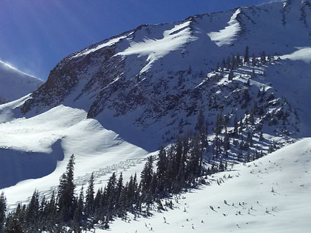
current conditions This report has been issued on the evening of Sunday, February 2, at 10:00 p.m. It is based on field work performed, and observations received, over the weekend of February 1-2. It is to be used a baseline for formulating your own danger analysis over the next several days. An unsettled weather pattern is setting up for the upcoming week, with the first chance of new snow coming late Monday and into Tuesday. Any new snowfall, accompanied by wind, will cause the danger to rise. La Sal Mountains Clouds began streaming in this afternoon closing out what could have been one of the best days of the season. For those of you who packed the parking lot today, to get in your licks before the Super Bowl, good on you! Three days have passed since the storm, and the snow still remains unaffected by wind. Riding and skiing conditions are excellent, and I ran into Kirstin Peterson and Dave Schipper in Gold Basin demonstrating just how good they remain.
In addition, Reports of good riding and skiing conditions on all aspects have streamed in from all corners of the range. Thanks to Brian Murray, Mark Sevenoff, and and Sarah Topp for their observations. Snow totals from Friday's storm were heavily elevation dependent, with 5" at Geyser Pass trailhead, 7" in Gold Basin, and up to a foot of light to medium density snow at upper elevations. Most of the new snow fell without wind. Temperatures in the mountains on Sunday remained cold, getting up into the high teens, and only the most sun exposed aspects were affected. Winds and Temperature on Pre-Laurel Peak (11,705') Temperature and new snow totals in Gold Basin (10,050') Total snow depth and temperature near Geyser Pass Trailhead (9850') Abajo Mountains More snow fell in the Abajo Mountains than previously reported with 9" of new observed at Dalton Springs near the North Creek Trailhead. I'll leave it to this great observation from Scott Watson to tell the story. Winds and temperature on Abajo Peak (11,330') Snow totals at Camp Jackson (8968') |
| type | aspect/elevation | characteristics |
|---|

|

|
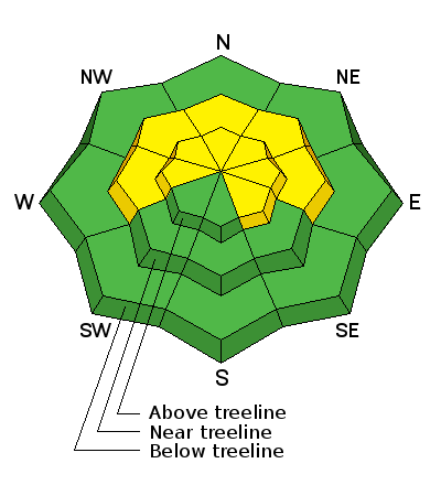
LIKELIHOOD
 LIKELY
UNLIKELY
SIZE
 LARGE
SMALL
TREND
 INCREASING DANGER
SAME
DECREASING DANGER
|
|
description
Friday's snow has now become a part of the persistent slab problem and we've begun to add straw to the proverbial camel's back. With less than an inch of water from this last storm, the load hasn't been much. Nevertheless, we are now on the rise when it comes to testing the strength of the many buried weaknesses, and more snow looks to be on the way this week. With the existing snow pack consisting largely of facets, facet crust combinations, and depth hoar, each new load of snow must be treated as suspect, especially when the added weight of skier or rider is factored in. A persistent slab triggered would be fairly large and dangerous, and this problem is not going to abate for some time. The photo below illustrates the new snow slab, with a variety of weaknesses beneath.
Well developed depth hoar at the bottom of the pack.
|
 |
weather An unsettled weather pattern is moving in for the upcoming week, with our first shot at snow coming in late Monday and into Tuesday. Monday: Snow, mainly after 9am. High near 18. West wind around 15 mph. Chance of precipitation is 80%. New snow accumulation of 2 to 4 inches possible. |
| general announcements OBSERVATIONS: If you are out and about in the mountains, I'd love to know what you are seeing so please SUBMIT OBSERVATIONS You can read current OBSERVATIONS HERE. LUNA GROOMING INFORMATION: Groomers started packing in the new snow on Sunday with a full groom scheduled for Monday. ROAD CONDITIONS: The road has not been plowed but has seen considerable traffic over the weekend. It is passable but snow packed and 4wd is recommended. San Juan County may get up for some plowing clean up on Monday or Tuesday so the road may be tempoosed while they do this. UAC MOBILE APP: Get your advisory on your iphone with this app
|


_2.jpg)