| During the month of April, Mark Miller will donate $75 to the charity of your choice (5 to chose from, including the Utah Avalanche Center!) Mark Miller Subaru has raised over $300k in the previous 6 Do Good Feel Good events. More Info here |  |

For every car Mark MIller Subaru sells in April, they will donate $75 to the charity of your choice (5 to choose from). Who are you going to choose? Plus - you can vote for your favorite and the 3 groups receiving the most votes get an additional cash prize donated by Mark Miller Subaru. Details here

| During the month of April, Mark Miller will donate $75 to the charity of your choice (5 to chose from, including the Utah Avalanche Center!) Mark Miller Subaru has raised over $300k in the previous 6 Do Good Feel Good events. More Info here |  |
| Advisory: Moab Area Mountains | Issued by Eric Trenbeath for Thursday - January 30, 2014 - 7:44am |
|---|
 |
current conditions
A vigorous winter storm is on our doorstep and we should get a good shot at snow over the next 24 hours. The main brunt of the storm should kick in tonight lasting into tomorrow with up to a foot of new snow possible. 2"-4" are possible today. Expect wind and blowing snow with SW winds averaging 20-30 mph along ridge tops with gusting to 40 mph. High temperatures at 10,000' will be around freezing. Winds and Temperature on Pre-Laurel Peak (11,705') Temperature and new snow totals in Gold Basin (10,050') Total snow depth and temperature near Geyser Pass Trailhead (9850') Winds and temperature on Abajo Peak (11,330') Snow totals at Camp Jackson (8968') |
| type | aspect/elevation | characteristics |
|---|


|


|

LIKELIHOOD
 LIKELY
UNLIKELY
SIZE
 LARGE
SMALL
TREND
 INCREASING DANGER
SAME
DECREASING DANGER
|
|
description
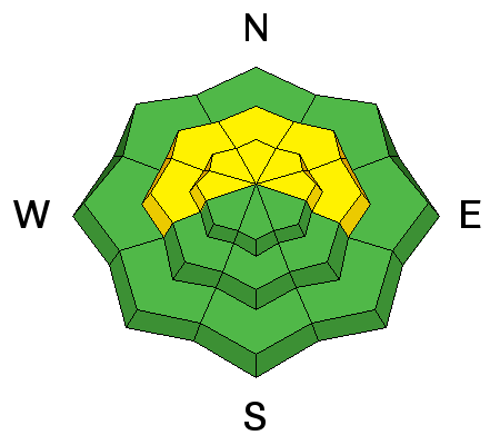
With new snow in the forecast accompanied by strong SW winds, expect to find rapidly developing wind slabs on leeward slopes, especially at upper elevations. Look for signs of instability such as cracking or collapsing. As the storm progresses, these slabs will grow larger and more dangerous, and by tomorrow, they may have the potential to affect buried, weaker layers triggering a larger, persistent slab.
|
| type | aspect/elevation | characteristics |
|---|


|


|

LIKELIHOOD
 LIKELY
UNLIKELY
SIZE
 LARGE
SMALL
TREND
 INCREASING DANGER
SAME
DECREASING DANGER
|
|
description
The snow pack is currently very weak, and in many cases, complex, with a variety of weak faceted layers, crust/facet combinations, as well as depth hoar. The foundation for new snow is terrible, and with new snow accompanied by strong winds in the forecast, we will have to be extremely vigilant. Expect the danger to rise dramatically if we receive significant snowfall. |
 |
weather Today, expect snow and blowing snow with 2-4" possible. Winds will be strong from the SW averaging 20-30 mph with gusts as high as 50 mph. Daytime highs at 10,000' will be around 32 degrees. Snow will continue through the night and into tomorrow with perhaps a foot of new snow possible by tomorrow night. Overnight lows will be in the low 20's. |
| general announcements OBSERVATIONS: If you are out and about in the mountains, I'd love to know what you are seeing so please SUBMIT OBSERVATIONS You can read current OBSERVATIONS HERE. LUNA GROOMING INFORMATION: Grooming is scheduled for Mondays and Fridays. Skating and cross-country skiing conditions remain excellent. ROAD CONDITIONS: The road is clear. UAC MOBILE APP: Get your advisory on your iphone with this app
|
Advisory Hotline: (888) 999-4019 | Contact Information