| During the month of April, Mark Miller will donate $75 to the charity of your choice (5 to chose from, including the Utah Avalanche Center!) Mark Miller Subaru has raised over $300k in the previous 6 Do Good Feel Good events. More Info here |  |
| During the month of April, Mark Miller will donate $75 to the charity of your choice (5 to chose from, including the Utah Avalanche Center!) Mark Miller Subaru has raised over $300k in the previous 6 Do Good Feel Good events. More Info here | |
| Advisory: Moab Area Mountains | Issued by Eric Trenbeath for Sunday - January 26, 2014 - 6:38am |
|---|

|
bottom line The avalanche danger is generally LOW at this time. Low danger doesn't mean no danger, and you still need to be alert to unstable snow on isolated terrain features. There are isolated pockets of MODERATE danger where it is possible to trigger a loose, faceted snow avalanche, primarily on very steep, shady terrain where the entire snow pack consists of weak, sugary snow. There also remains a very isolated MODERATE danger for triggering a buried persistent slab, or older wind slab, primarily on upper elevation terrain, steeper than about 40 degrees that faces the north half of the compass.
|
 |
current conditions
La Sal Mountains This report is getting very dull I must agree. At the very least, mild temperatures and sunny skies make for beautiful days in mountains. Travel is easy and the snow is mostly stable making it possible to get up into the high country or undertake a mountaineering adventure. Winds are light from the NW this morning but will increase to 15-20 mph along the ridge tops. Overnight lows have been in the low 20's. The snow surface remains an extremely mixed bag with a variety of hard and breakable wind and sun crusts in exposed areas. Some of the wind crusts are breaking down and it is possible to find soft, re-crystallized snow up there. On shady aspects below tree line, faceted grains, or sugar snow have taken over most of the pack. South faces at mid and upper elevations are hanging in there but getting thin. "Corn"-like conditions exist on these sunnier aspects, with a firm, supportable crust in the morning that softens through the course of the day. There is currently 35" on the ground in Gold Basin, and 21" at the Geyser Pass Trailhead. Winds and Temperature on Pre-Laurel Peak (11,705') Temperature and new snow totals in Gold Basin (10,050') Total snow depth and temperature near Geyser Pass Trailhead (9850') Abajo Mountains Camp Jackson continues to report 19" on the ground at 9000'. Low snow conditions with weak, faceted snow prevail. Many sun exposed slopes showing bare ground. Winds and temperature on Abajo Peak (11,330') Snow totals at Camp Jackson (8968') |
| type | aspect/elevation | characteristics |
|---|

|

|
LIKELIHOOD
 LIKELY
UNLIKELY
SIZE
 LARGE
SMALL
TREND
 INCREASING DANGER
SAME
DECREASING DANGER
|
|
description
As the faceting process takes over the snow pack, there are areas where it is possible to trigger a loose, faceted snow avalanche. This danger exists primarily on steep, shady, sheltered slopes at mid to upper mid elevations.You can recognize these areas where the snow is unsupportable, or barely supportable for a skier or snowmobile, and where you can stick your ski pole right through to the ground. Though not large, these loose snow avalanches can sweep you of your feet, slamming you into trees or carrying you over a rock band.
|
| type | aspect/elevation | characteristics |
|---|

|

|
LIKELIHOOD
LIKELY
UNLIKELY
SIZE
 LARGE
SMALL
TREND
 INCREASING DANGER
SAME
DECREASING DANGER
|
|
description
The snow pack is currently very weak, and in many cases, complex, with a variety of weak faceted layers, crust/facet combinations, as well as depth hoar. Persistent slabs themselves are deteriorating, but they can still be found, primarily on upper elevation terrain facing the north half of the compass. Spatial variability is the key phrase here with a a wide range of varying snow depths, particularly in exposed, upper elevations. Persistent north winds have scoured typical starting zones, so areas to suspect are further down slope than usual. This danger is very isolated, and persistent slabs would be difficult to difficult trigger, nevertheless, they would be fairly large and dangerous. |
| type | aspect/elevation | characteristics |
|---|

|
|
LIKELIHOOD
LIKELY
UNLIKELY
SIZE
LARGE
SMALL
TREND
INCREASING DANGER
SAME
DECREASING DANGER
|
|
description
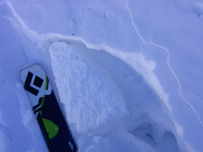
It is still possible to find an isolated wind slab out there. If you are traveling in extreme, upper elevation terrain, take note of suspect terrain features where these very isolated pockets may exist. Look for signs such as cracking or collapsing. I found this piece on a an upper elevation, NNW facing slope beneath a rock buttress. All around it, the snow was shallow and sugary or crusted over.
|
 |
weather A carrot is finally being dangled out there for later this week, and we should see a change in the weather pattern by about Wednesday. Though confidence in strength is low, a series of moist Pacific storms are poised to move across the Western U.S. beginning on Wednesday and continuing through the weekend. As the western ridge begins to break down, we may say a few high clouds streaming into the area, but expect mostly sunny skies over the next few days with continued high temperatures to be in the low to mid 30's. NW winds will steadily be in the increase, averaging 10-15 mph and gusting to 25 mph along ridge tops. Their average will increase by about 10 mph per day over the next few days.
|
| general announcements OBSERVATIONS: If you are out and about in the mountains, I'd love to know what you are seeing so please SUBMIT OBSERVATIONS You can read current OBSERVATIONS HERE. LUNA GROOMING INFORMATION: Grooming is scheduled for Mondays and Fridays. Skating and cross-country skiing conditions remain excellent. ROAD CONDITIONS: The road is clear. UAC MOBILE APP: Get your advisory on your iphone with this app
|


_2.jpg)