| During the month of April, Mark Miller will donate $75 to the charity of your choice (5 to chose from, including the Utah Avalanche Center!) Mark Miller Subaru has raised over $300k in the previous 6 Do Good Feel Good events. More Info here |  |
| During the month of April, Mark Miller will donate $75 to the charity of your choice (5 to chose from, including the Utah Avalanche Center!) Mark Miller Subaru has raised over $300k in the previous 6 Do Good Feel Good events. More Info here | |
| Advisory: Moab Area Mountains | Issued by Eric Trenbeath for Saturday - January 11, 2014 - 6:33am |
|---|

|
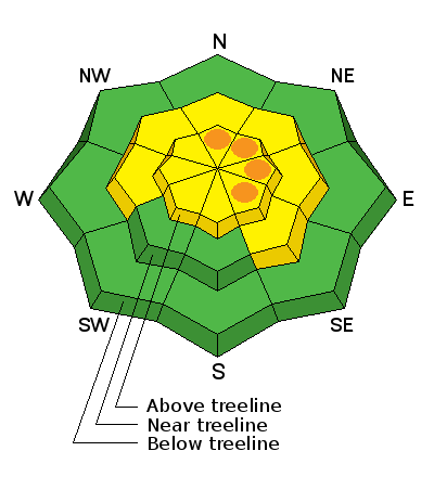
bottom line Pockets of CONSIDERABLE danger, where human triggered avalanches are likely, exist above tree line on slopes steeper than 35 degrees where there are recent deposits of wind drifted slow. This danger is pre-dominate on slopes with a NE-E-SE aspect. There is a MODERATE avalanche danger in wind affected terrain below tree line that have areas of wind drifted snow . The danger is generally LOW on sheltered, lower elevation terrain.
|
 |
current conditions
La Sal Mountains Snow totals from this last event varied greatly with elevation. Only about an inch fell at GPTH, while the Gold Basin study plot picked up 3". Above about 10,500', 4"-5" of light density snow could be found. The new snow was accompanied by lots of wind above tree line, but surprisingly little below. Ridge top winds from the WNW, averaged 15-20 mph with gusts in the 30's for most of the day yesterday. They've backed off this morning, averaging 10 mph with gusts to 15. Current temperature on Pre Laurel Peak is 17 degrees. Abajo Mountains Camp Jackson is reporting no new snow but trace amounts were reported at the Harts Draw winter trailhead. This will have done little to improve things, and low snow conditions prevail in the Abajos. Snow depths range from about 18"-24" of snow about 10,000' on shady aspects. Bare ground is exposed on south facing slopes, and even east facing slopes with a slight southerly component are showing areas of exposed ground. |
 |
recent activity . |
| type | aspect/elevation | characteristics |
|---|

|
|
LIKELIHOOD
 LIKELY
UNLIKELY
SIZE
 LARGE
SMALL
TREND
 INCREASING DANGER
SAME
DECREASING DANGER
|
|
description
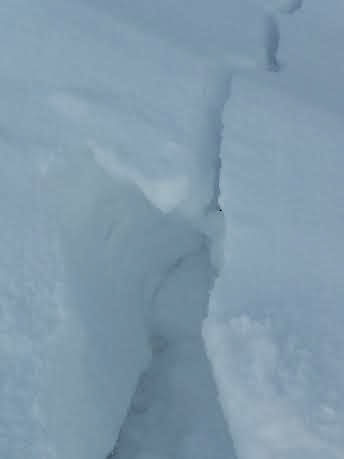
Rule number 1: Never underestimate the power of the wind, especially when there is a few inches of snow involved. In my travels yesterday, I found recently deposited wind slabs along the lee sides of ridge crests up to a foot deep. These were found primarily on slopes with a NE-E-SE aspect, but I also found them on westerly aspects where cross loading was a factor. Slabs were bonding poorly to the old snow surface, and if you trigger one, the potential exists to step down into persistent weak layers.
Cracking up to a foot deep on East facing ridge crest indicating recently deposited wind slab.
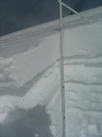
Wind slab over riding a weak, crust/facet combination. |
| type | aspect/elevation | characteristics |
|---|

|

|
LIKELIHOOD
 LIKELY
UNLIKELY
SIZE
 LARGE
SMALL
TREND
INCREASING DANGER
SAME
DECREASING DANGER
|
|
description
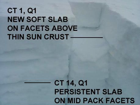
New wind slabs have re-activated the potential for triggering a deeper, persistent slab. The snow pack remains extremely weak with a variety of buried faceted layers, facet crust combinations, and depth hoar. Compression tests displayed reactive weak layers throughout the pack.
|
 |
weather We'll see a break this morning, with clouds developing later in the day ahead of the next storm system moving into our area. This system is again mostly north of us, but we could pick up a few more inches by Sunday night. Winds today will be from the SW, in the 10-15 mph range along ridge tops, and high temperatures at 10,000' will be in the upper 20's. |
| general announcements OBSERVATIONS: Thanks to Evan, Matt, and Ryan for your recent observations. You can read OBSERVATIONS HERE. If you are out and about in the mountains, I'd love to know what you are seeing so please SUBMIT OBSERVATIONS LUNA GROOMING INFORMATION: Groomers were out packing in the new snow yesterday and conditions are excellent. ROAD CONDITIONS: The road is clear. UAC MOBILE APP: Get your advisory on your iphone with this app
|


_2.jpg)