
| During the month of April, Mark Miller will donate $75 to the charity of your choice (5 to chose from, including the Utah Avalanche Center!) Mark Miller Subaru has raised over $300k in the previous 6 Do Good Feel Good events. More Info here |  |
| During the month of April, Mark Miller will donate $75 to the charity of your choice (5 to chose from, including the Utah Avalanche Center!) Mark Miller Subaru has raised over $300k in the previous 6 Do Good Feel Good events. More Info here | |
| Advisory: Moab Area Mountains | Issued by Eric Trenbeath for Friday - January 10, 2014 - 6:53am |
|---|

|
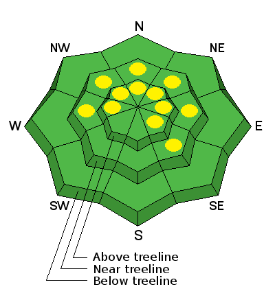
bottom line A MODERATE but isolated avalanche danger still exists for triggering a buried, persistent slab. Though isolated, this problem still exists on upper mid elevation slopes steeper than about 35 degrees that have a NW-NE aspect. Suspect areas down slope from ridge tops and beneath rock bands. There is also a MODERATE danger of triggering a small, isolated wind slab on slopes with recent deposits of wind drifted snow.Elsewhere in the range, the avalanche danger is generally LOW.
|
 |
current conditions
La Sal Mountains Light snow fell in the mountains yesterday, and though we only picked up 2" of new snow, it sure felt good to be out in some weather! This dusting helped refresh conditions in sheltered areas where settled, re-crystallized power conditions remained, but I'm afraid it will have done little for the overall picture. Winds shifted from the WSW to NW overnight averaging about 18 mph with gusts in the high 20's. It will be a bit blustery in the mountains today with continued NW winds in the 10-20 mph range. High temperatures will be in the upper 20's, and skies will be mostly cloudy. It is currently 14 degrees at 10,000'. Abajo Mountains Camp Jackson is reporting no new snow but trace amounts were reported at the Harts Draw winter trailhead. This will have done little to improve things, and low snow conditions prevail in the Abajos. Snow depths range from about 18"-24" of snow about 10,000' on shady aspects. Bare ground is exposed on south facing slopes, and even east facing slopes with a slight southerly component are showing areas of exposed ground. |
 |
recent activity . |
| type | aspect/elevation | characteristics |
|---|

|
|
LIKELIHOOD
 LIKELY
UNLIKELY
SIZE
 LARGE
SMALL
TREND
 INCREASING DANGER
SAME
DECREASING DANGER
|
|
description
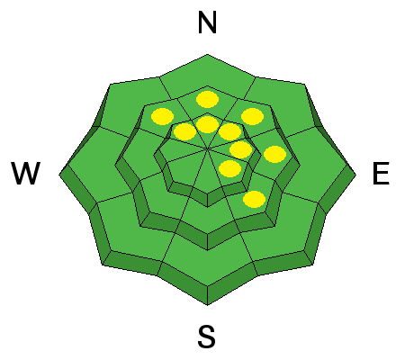
There was some snow blowing around yesterday, and winds will continue to blow today. Be on the lookout for small, isolated wind slabs developing along the lee sides of terrain features, primarily on slopes with NW-N-SE aspects.
|
| type | aspect/elevation | characteristics |
|---|

|
|
LIKELIHOOD
LIKELY
UNLIKELY
SIZE
 LARGE
SMALL
TREND
INCREASING DANGER
SAME
DECREASING DANGER
|
|
description
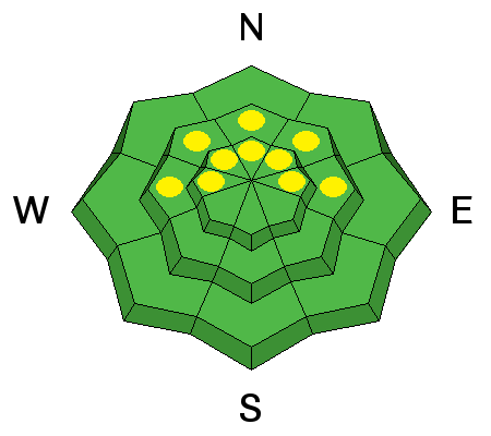
New snow totals have not added significant weight to our persistent weak layers. Nevertheless, it still may be possible to trigger a buried persistent slab though this danger is quite isolated. You are most likely to find these slabs on upper-mid elevation, NW-NE aspects steeper than 35 degrees, particularly in areas of rocky or extreme terrain.
|
 |
weather Skies will be mostly cloudy in the mountains today moving to partly cloudy this evening. High temperatures at 10,000' will be in the upper 20's, and winds will be from the NW at 10-20 mph. Another storm system passing to our north, will keep us under mostly cloudy skies through the weekend with a chance of snow Saturday, and Saturday night. |
| general announcements OBSERVATIONS: If you are out and about in the mountains, I'd love to know what you are seeing. Please submit your OBSERVATIONS HERE LUNA GROOMING INFORMATION: Groomers will be out today packing in the fresh new snow. ROAD CONDITIONS: Expect a light dusting on the road. UAC MOBILE APP: Get your advisory on your iphone with this app
|


_2.jpg)