
| During the month of April, Mark Miller will donate $75 to the charity of your choice (5 to chose from, including the Utah Avalanche Center!) Mark Miller Subaru has raised over $300k in the previous 6 Do Good Feel Good events. More Info here |  |
| During the month of April, Mark Miller will donate $75 to the charity of your choice (5 to chose from, including the Utah Avalanche Center!) Mark Miller Subaru has raised over $300k in the previous 6 Do Good Feel Good events. More Info here | |
| Advisory: Moab Area Mountains | Issued by Eric Trenbeath for Friday - January 3, 2014 - 6:59am |
|---|

|
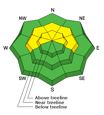
bottom line A LEVEL 2 or MODERATE avalanche danger exists at this time. Buried, persistent slabs overlying weak, sugary snow, remain the prime area of concern. Though this problem is becoming more isolated, it still exists on mid to upper elevation slopes steeper than about 35 degrees that have a NW-NE aspect. There is also a MODERATE danger of triggering a loose snow avalanche on steep shady slopes, primarily at upper mid elevations, where the snow pack has been taken over by the faceting process. Elsewhere in the range, the avalanche danger is generally LOW.
|
 |
current conditions Winds on Pre Laurel Peak and on Abajo Peak have been mostly light out of the WSW overnight. They have picked up into the teens the past couple of hours with gusts into the low 20's, Overnight low temperatures at 10,000' have been about 20 degrees. La Sal Mountains Wind and sun continue to work over our diminishing snow pack, and surface conditions run the full gamete out there right now. Breakable, and supportable sun crusts can be found on sunny exposures, and wind crusts abound on exposed shadier aspects. Soft, settled, re-crystallized powder conditions can still be found in sheltered areas but they are getting harder to find. One tip in semi-exposed areas, look for an "etched" snow surface. This snow is actually softer than the deceiving, smooth areas that are often stiff, breakable wind crusts. Much of the pack is being taken over by facets, which means that it is turning into a pile of sugar, particularly on sheltered, mid-elevation slopes, In these areas, it is possible to sink right through to the ground through 20"-30" of snow. There is currently 21" on the ground at Geyser Pass Trailhead, and 33" in Gold Basin. Abajo Mountains Low snow conditions prevail in the Abajos. Snow depths range from about 18"-24" of snow above about 10,000' on shady aspects. Bare ground is exposed on south facing slopes, and even east facing slopes with a slight southerly component are showing areas of exposed ground. Snow surface conditions run the full gamete similar to the La Sals. The Snotel site at Camp Jackson is reporting 19" on the ground. |
 |
recent activity . |
| type | aspect/elevation | characteristics |
|---|

|
|
LIKELIHOOD
 LIKELY
UNLIKELY
SIZE
 LARGE
SMALL
TREND
 INCREASING DANGER
SAME
DECREASING DANGER
|
|
description
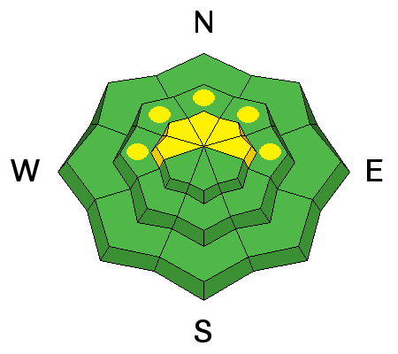
It is still possible to trigger a buried persistent slab though this danger is becoming more isolated. You are most likely to find these slabs on upper elevation, NW-NE aspects steeper than 35 degrees, particularly in areas of rocky terrain. In my travels up and around Mann's peak yesterday however, I observed that many of these slopes had been scoured out from continued, northerly winds. You will need to be alert to areas that have a smooth, rounded appearance. Be cautious of convexities, and watch out for isolated pockets on the lee sides of terrain features, and beneath rock bands. Of greater concern for the future is our existing snow pack. it consists of a variety of weak layers including buried surface hoar, depth hoar, facet/crust combinations, and areas where the entire pack has turned to faceted, sugary snow. This type of snow pack structure does not bode well for the future, and we are now playing a waiting game in anticipation of the next snow load. |
| type | aspect/elevation | characteristics |
|---|

|
|
LIKELIHOOD
 LIKELY
UNLIKELY
SIZE
 LARGE
SMALL
TREND
INCREASING DANGER
SAME
DECREASING DANGER
|
|
description
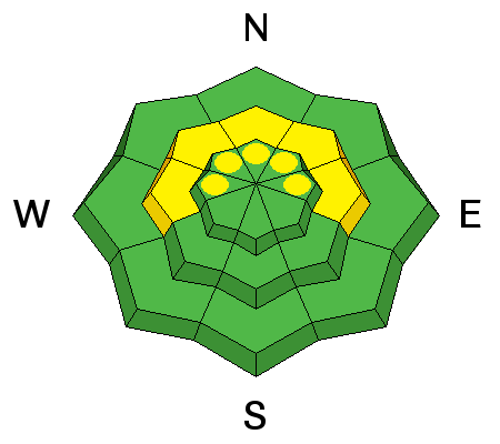
Much of the snow pack is turning into a pile of facets, or loose, weak, non-cohesive snow. This snow can sluff off as a pile of sand, entraining more snow as it goes. And though it most likely won't bury you, it can sweep you off your feet, carry you over a rock band, or onto a buried, persistent slab. This problem is most prevalent on steep shady slopes at upper mid elevations. |
 |
weather Clear skies this morning should yield to increasing clouds later in the day as a storm system to the north begins to affect our area. Winds will also on the increase from the WSW, averaging 15 mph with gusting to 30, High temperatures at 10,000' will be around freezing.On Saturday, winds will increase and shift to the NW with gusts as high as 45 mph. There is a slight chance for snow tonight through Saturday night. |
| general announcements The Utah Avalanche Center along with the Montana State University Ski Tracks project combines GPS technology with detailed logbook surveys completed by participants to help us understand how and why decisions are made in the winter backcountry. Participants will use a free smartphone app to record and send us their ski routes then, they will complete a simple online survey telling us some of the features of their tour. For more information visit http://www.montana.edu/wwwes/facilities/tracks.htm?origin=snowscience OBSERVATIONS: If you are out and about in the mountains, I'd love to know what you are seeing. Please submit your OBSERVATIONS HERE LUNA GROOMING INFORMATION: All trails including the upper meadows at Geyser Pass and the road into Gold Basin were groomed earlier this week, with a re-groom scheduled for today. ROAD CONDITIONS: The road is clear with a packed surface of snow. UAC MOBILE APP: Get your advisory on your iphone with this app
|


_2.jpg)
