
| During the month of April, Mark Miller will donate $75 to the charity of your choice (5 to chose from, including the Utah Avalanche Center!) Mark Miller Subaru has raised over $300k in the previous 6 Do Good Feel Good events. More Info here |  |
| During the month of April, Mark Miller will donate $75 to the charity of your choice (5 to chose from, including the Utah Avalanche Center!) Mark Miller Subaru has raised over $300k in the previous 6 Do Good Feel Good events. More Info here | |
| Advisory: Moab Area Mountains | Issued by Eric Trenbeath for Saturday - December 21, 2013 - 7:02am |
|---|


|
bottom line There is currently a LEVEL 2 (MODERATE) avalanche danger at this time. Buried, persistent slabs overlying weak, sugary snow, remain the prime area of concern. Though continually lessening, this problem still exists on mid to upper elevation slopes steeper than about 35 degrees that have a NW-NE aspect. The second danger is recently deposited wind slabs from active and changing wind directions the past couple of days. This danger is possible on all aspects at upper elevations, but will likely present itself as small, isolated pockets on the lee sides of ridge crests and terrain features. Elsewhere in the range, the avalanche danger is generally LOW.
|
 |
special announcement . |
 |
current conditions With light snow falling in town, one would hope we were receiving more in the mountains. As it is, we're running neck and neck with barely a trace in either place. I found 2" of new in the mountains during my travels yesterday, and we could see 1-3" today so we'll take what we get and try to like it! Overnight winds have been light out of the NW, picking up into the teens the last couple of hours, and high temperatures today will be in the low 20's. My foray over to Cork Screw Glades on Thursday made it clear that we could use more snow. Once you got there, skiing was actually quite good on settled, re-crystallized powder with about a 20" base at the bottom of the glades, and close to 30" at the top. But the trek over and back bordered on unmanageable with low snow, a mixed bag of surface conditions, and exposed ground on southerly aspects. Higher up in the range, there is still plenty of snow to slide around on, but our awesome start has tapered off. In addition, the snowpack is growing weaker and weaker as the faceting process is beginning to take over the entire snowpack on shady aspects. What this means is that the snowpack is turning into a weak pile of sugar, which won't hold up well when we finally get another load of snow on top. |
 |
recent activity . |
| type | aspect/elevation | characteristics |
|---|

|
|
LIKELIHOOD
 LIKELY
UNLIKELY
SIZE
 LARGE
SMALL
TREND
 INCREASING DANGER
SAME
DECREASING DANGER
|
|
description
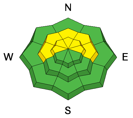
Buried, persistent slabs continue to be the main area of concern though the odds of triggering one of these slabs are growing less likely. However, very weak, faceted, sugary snow snow still underlies them and a slide triggered under these conditions would be large and dangerous. Continue to avoid steep, northerly facing, upper elevation terrain. Be particularly leery of rocky terrain and areas beneath cliff bands. Suspect areas with a smooth, rounded appearance, and be alert to the many steep convexities in our mountain range. This type of terrain can lure you far down a slope to where if a slide is released, it will fracture well above you. |
| type | aspect/elevation | characteristics |
|---|

|
|
LIKELIHOOD
LIKELY
UNLIKELY
SIZE
 LARGE
SMALL
TREND
INCREASING DANGER
SAME
DECREASING DANGER
|
|
description
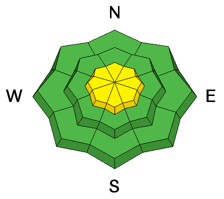
Active winds over the past couple of days may have formed isolated wind slabs at upper elevations. They started out strong out of the SSW on Thursday, backing off and swinging around to the NW yesterday. These pockets will likely be small, but they could sweep you off your feet and carry you over a rock band or on to a more dangerous, buried persistent slab. Be alert on all aspects at upper elevations for recent deposits of wind drifted snow on slopes steeper then 35 degrees. |
 |
weather Snow showers should linger through today with 1"-3" of new snow possible. Winds will be light out of the NW and temperatures at 10,000 feet will be in the low 20's. By Sunday, things again begin to dry out, Look for partly cloudy to mostly sunny skies, continued light, NW winds and high temperatures again in the low to mid 20's. An uneventful weather pattern is lined up for next week. For the most up to date wind and temperature conditions, go to our automated weather station at 11,600' on Pre Laurel Peak click here: http://mesowest.utah.edu/cgi-bin/droman/meso_base.cgi?stn=lsl For new snow totals in Gold Basin click here: http://mesowest.utah.edu/cgi-bin/droman/meso_base.cgi?stn=goldb |
| general announcements OBSERVATIONS: If you are out and about in the mountains, I'd love to know what you are seeing. Please submit your observations here: http://utahavalanchecenter.org/bc_obs_1 To view observations posted by others, go here: http://utahavalanchecenter.org/observations/moab LUNA GROOMING INFORMATION: Ed and Dave were out grooming yesterday. They did a full groom into Gold Basin, and ran the barrel up to Geyser Pass. Conditions were good but a little slow. ROAD CONDITIONS: Plow crews will be initiating road closures during plowing this season due to conflicts with traffic. The plan is to call me the day before they plan to plow so I can post it in this advisory. This closure could take up to two hours so please plan accordingly. Do not expect plowing over the weekend. San Juan County does an excellent job keeping our road open but please keep in mind that their first priority after a storm is to open roads in and around populated areas. UAC MOBILE APP: Get your advisory on your iphone here: https://itunes.apple.com/us/app/utah-avalanche-center/id605579982?mt=8
|


_2.jpg)