25th Annual Black Diamond Fall Fundraising Party
Thursday, September 13; 6:00-10:00 PM; Black Diamond Parking Lot
25th Annual Black Diamond Fall Fundraising Party
Thursday, September 13; 6:00-10:00 PM; Black Diamond Parking Lot
| Advisory: Logan Area Mountains | Issued by Toby Weed for Friday - January 19, 2018 - 7:09am |
|---|

|
bottom line Heightened avalanche conditions exist in the backcountry, and the danger is MODERATE. Drifting snow from a strong winter storm will cause the avalanche danger to rise today. Human-triggered avalanches are possible in exposed terrain at upper and mid-elevations. Evaluate snow and terrain carefully.
|
 |
current conditions The Tony Grove Snotel at 8400' reports 37°F, and there's 49 inches of total snow at the site containing 92% of normal SWE (Snow Water Equivalent). It's 27°F at the the Ogden Peak weather station, with 50 mph south wind and gusts close to 70 mph. We found good stability yesterday in the Logan Peak Area, but a winter storm today will once again create heightened avalanche conditions in the backcountry. Human triggered avalanches are possible, especially in drifted terrain and areas where the snow is generally shallow.
|
 |
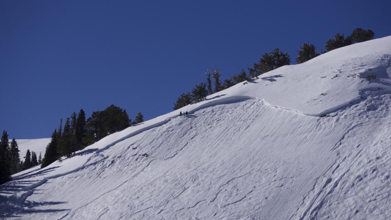
recent activity A couple close calls occurred in the Logan Zone over the weekend.
Paige and Kory looking at the broad crown of Sunday's large sled triggered avalanche in upper Providence Canyon near Logan Peak. |
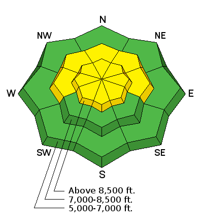
| type | aspect/elevation | characteristics |
|---|

|
|
LIKELIHOOD
 LIKELY
UNLIKELY
SIZE
 LARGE
SMALL
TREND
 INCREASING DANGER
SAME
DECREASING DANGER
|
|
description
Although the snow on most slopes is stable and persistent slab avalanches are fairly unlikely, the size of potential avalanches and the consequences of triggering one remain the same. Persistent slab avalanches are possible on slopes with poor snow structure.
|
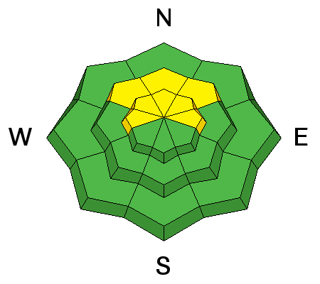
| type | aspect/elevation | characteristics |
|---|

|
|
LIKELIHOOD
 LIKELY
UNLIKELY
SIZE
 LARGE
SMALL
TREND
 INCREASING DANGER
SAME
DECREASING DANGER
|
|
description
Drifting of today's new snow will create heightened wind slab avalanche conditions in exposed terrain.
|
 |
weather The National Weather Service has issued a Winter Weather Advisory for the mountains of far northern Utah. A cold and moist storm system will move off the eastern Pacific and will track across the Great Basin through the weekend. This storm will impact much of Utah and southwest Wyoming tonight through early Sunday.
|
| general announcements We're excited to introduce for the 2017/2018 winter the Utah Avalanche Center podcast, hosted by forecaster Drew Hardesty and produced by KUER's Benjamin Bombard. The podcast will include engaging stories, interviews, and lessons learned - all things avalanche to help keep people on top of the snow instead of buried beneath it - and easily found on ITunes, Stitcher, the UAC blog, or wherever you get your podcasts. Discount lift tickets for Alta, Snowbird, Brighton, Solitude, Deer Valley, Snowbasin, and Beaver Mountain are now available, donated by the resorts to benefit the Utah Avalanche Center. Details and order information here. All proceeds go towards paying for avalanche forecasting and education! Now is a great time to practice companion rescue techniques with your backcountry partners. Here's our rescue practice video. Go HERE for a list of UAC classes. EMAIL ADVISORY: If you would like to get the daily advisory by email you will need to subscribe here. Benefit the Utah Avalanche Center when you shop from Backcountry.com or REI: Click this link for Backcountry.com or this link to REI, shop, and they will donate a percent of your purchase price to the UAC. Both offer free shipping (with some conditions) so this costs you nothing! Benefit the Utah Avalanche Center when you buy or sell on ebay - set the Utah Avalanche Center as a favorite non-profit in your ebay account here and click on ebay gives when you buy or sell. You can choose to have your seller fees donated to the UAC, which doesn't cost you a penny. Remember your information can save lives. If you see anything we should know about, please help us out by submitting snow and avalanche observations. You can also call us at 801-524-5304, email by clicking HERE, or include #utavy in your tweet or Instagram. This advisory is from the U.S.D.A. Forest Service, which is solely responsible for its content. This advisory describes general avalanche conditions and local variations always occur. |