| Please join us at the 23rd annual Black Diamond Fall Fundraiser Party Thursday Sept 15. Tickets are on sale now here, at the Black Diamond store & at REI. Special bonus raffle for online ticket purchasers! |
| Please join us at the 23rd annual Black Diamond Fall Fundraiser Party Thursday Sept 15. Tickets are on sale now here, at the Black Diamond store & at REI. Special bonus raffle for online ticket purchasers! |
| Advisory: Logan Area Mountains | Issued by Toby Weed for Thursday - March 24, 2016 - 7:21am |
|---|

|
bottom line MODERATE (level 2): Heightened wind slab avalanche conditions exist, and you could trigger avalanches on drifted slopes at upper elevations. Solar warming may cause increasing loose wet avalanche danger on sunny slopes later today. Evaluate the snow and terrain carefully, and continue to avoid drifted upper elevation slopes.
|
 |
current conditions The Tony Grove Snotel at 8400' reports 25 degrees, and there's 92 inches of total snow containing 105% of average water for the date. I'm reading 19 degrees at the 9700' CSI Logan Peak weather station, with steady west winds, now averaging around 20 mph. We found nice powder conditions yesterday, with significantly more new snow the high up we got. There were large drifts from sustained northwest winds during the storm, and we could see evidence of some natural wet sluff and wind slab avalanche activity.
|
 |
recent activity
***To view our updated list of backcountry observations and avalanche activity from around Utah, go to our observations page
|
| type | aspect/elevation | characteristics |
|---|

|
|
LIKELIHOOD
 LIKELY
UNLIKELY
SIZE
 LARGE
SMALL
TREND
 INCREASING DANGER
SAME
DECREASING DANGER
|
|
description
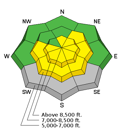
Heightened wind slab and cornice fall conditions exist due to significant recent accumulations and drifting at upper and mid elevations, with avalanches possible on many slopes.
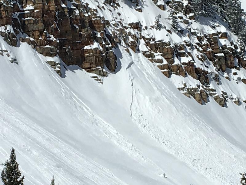
Overrunning snow from a natural wet sluff triggered this larger wind slab avalanche under the cliffs of Boiler Buttress in Steam Mill Canyon. The avalanche involved only new snow from Tuesday and overnight and occurred around noon yesterday. (3-23-16)
|
| type | aspect/elevation | characteristics |
|---|

|
|
LIKELIHOOD
LIKELY
UNLIKELY
SIZE
LARGE
SMALL
TREND
 INCREASING DANGER
SAME
DECREASING DANGER
|
|
description
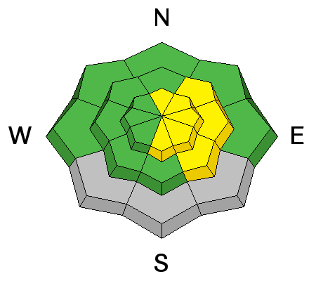
If the high angled March sun comes out for a while later today, loose wet avalanches entraining a good amount of fresh snow will become possible, especially in sheltered sunny terrain.
|
 |
weather HIGH PRESSURE ACROSS THE AREA WILL GIVE WAY TO A COLD FRONT WHICH WILL SWEEP ACROSS NORTHERN UTAH THIS EVENING. THIS WILL BE FOLLOWED BY A SECOND WEATHER SYSTEM LATE FRIDAY THROUGH SATURDAY. A COLDER AND STRONGER STORM WILL SETTLE INTO THE GREAT BASIN EARLY NEXT WEEK. |
| general announcements The National Avalanche Center recently completed an animated tutorial on the North American Avalanche Danger Scale. HERE Please submit snow and avalanche observations from your ventures in the backcountry HERE. You can call us at 801-524-5304 or email HERE, or include #utavy in your Instagram or Tweet us @UAClogan. To report avalanche activity in the Logan Area or to contact the local avalance forecaster call me, Toby, at 435-757-7578. We'll update this advisory throughout the season on Monday, Wednesday, Friday, and Saturday mornings by about 7:30 This advisory is produced by the U.S.D.A. Forest Service, which is solely responsible for its content. It describes only general avalanche conditions and local variations always exist.
|