| Please join us at the 23rd annual Black Diamond Fall Fundraiser Party Thursday Sept 15. Tickets are on sale now here, at the Black Diamond store & at REI. Special bonus raffle for online ticket purchasers! |
| Please join us at the 23rd annual Black Diamond Fall Fundraiser Party Thursday Sept 15. Tickets are on sale now here, at the Black Diamond store & at REI. Special bonus raffle for online ticket purchasers! |
| Advisory: Logan Area Mountains | Issued by Toby Weed for Monday - March 21, 2016 - 7:23am |
|---|

|
bottom line MODERATE (level 2): Triggered wind slab avalanches and large cornice falls are possible at in drifted upper and mid-elevation terrain. The danger of loose wet avalanches entraining last week's new snow will rise, especially in sheltered shady areas with daytime heating as the snow is warmed and it becomes saturated. Evaluate the snow and terrain carefully, avoid drifted terrain, and stay off of and out from under steep slopes with saturated snow in the heat of the day.
|
 |
special announcement ***Please take time to complete a quick survey that will help us better serve you in the future. HERE
|
 |
current conditions The snow was still nice and dry on north facing slopes yesterday, but the powerful March sun certainly got to sunny slopes and the fresh snow from last week is now pretty saturated in many areas. A superficial crust may have formed on the surface on some slopes, but overnight temperatures stayed well above freezing at all stations and I expect these will soften early with today's heat. The warmth may dampen fresh surface snow on shady slopes as well as those facing south, potentially creating widespread heightened wet avalanche conditions. The Tony Grove Snotel at 8400' reports a toasty 42 degrees this morning and 90 inches of total snow containing 104% of average water for the date. I'm reading 32 degrees at the 9700' CSI Logan Peak weather station, with somewhat diminishing southwest winds, now averaging around 22 mph, after cranking out 35 mph averages overnight, with gusts in the 50s.
|
 |
recent activity Local trail heads overflowed all weekend and riders tested numerous steep slopes in the Central Bear River Range, but certainly not without incident.
***To view our updated list of backcountry observations and avalanche activity from around Utah, go to our observations page
|
| type | aspect/elevation | characteristics |
|---|

|

|
LIKELIHOOD
 LIKELY
UNLIKELY
SIZE
 LARGE
SMALL
TREND
 INCREASING DANGER
SAME
DECREASING DANGER
|
|
description
Heightened wind slab and cornice fall conditions exist in drifted terrain. Strong southwest wind overnight may have found a bit of snow to drift and fresh wind slabs probably formed in some exposed terrain. Large wind slabs and cornices formed last week due to sustained westerly wind, sometimes during periods of heavy snowfall. Persistent Wind Slabs?- A weak layer appears to have developed at the interface between the warm melt freeze snow from the early March warm spell and the large amount of new snow which started falling on Monday (4-13-16) and continued until Thursday morning. A layer of graupel and very moist snow from Saturday's thunder squall is now faceted due to the concentrated temperature gradient that the layer was subjected to.
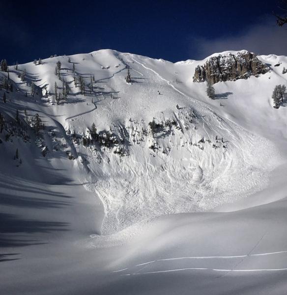
A beautiful photo by Jeremy Jensen (the Mayor of Tony Grove) from Saturday morning showing a recent natural avalanche in Castle Rock near Naomi Peak. The large wind slab (or perhaps persistent slab) looks like it was triggered by cornice fall. (3-19-16)
|
| type | aspect/elevation | characteristics |
|---|

|
|
LIKELIHOOD
 LIKELY
UNLIKELY
SIZE
 LARGE
SMALL
TREND
 INCREASING DANGER
SAME
DECREASING DANGER
|
|
description
Loose wet avalanches entraining large piles of last week's fresh snow are possible and may become likely with daytime warmth today, especially in sheltered terrain and on shady slopes where the snow was still fairly dry yesterday. Debris piles could be fairly large especially on sustained steep slopes. The danger of wet avalanches may rise to Considerable on some slopes, with large natural wet avalanches possible.
A good sized natural loose wet avalanche in North Wood Camp that occurred around 4:00 yesterday afternoon (3-20-16)
|
 |
weather A COLD PACIFIC STORM SYSTEM WILL IMPACT UTAH THE FIRST HALF OF THE WEEK. Today: Scattered snow showers after noon. Mostly cloudy, with a high near 48. West wind 16 to 21 mph. Chance of precipitation is 30%. Total daytime snow accumulation of less than a half inch possible. |
| general announcements The National Avalanche Center recently completed an animated tutorial on the North American Avalanche Danger Scale. HERE Please submit snow and avalanche observations from your ventures in the backcountry HERE. You can call us at 801-524-5304 or email HERE, or include #utavy in your Instagram or Tweet us @UAClogan. To report avalanche activity in the Logan Area or to contact the local avalance forecaster call me, Toby, at 435-757-7578. We'll update this advisory throughout the season on Monday, Wednesday, Friday, and Saturday mornings by about 7:30 This advisory is produced by the U.S.D.A. Forest Service, which is solely responsible for its content. It describes only general avalanche conditions and local variations always exist.
|