| Please join us at the 23rd annual Black Diamond Fall Fundraiser Party Thursday Sept 15. Tickets are on sale now here, at the Black Diamond store & at REI. Special bonus raffle for online ticket purchasers! |
| Please join us at the 23rd annual Black Diamond Fall Fundraiser Party Thursday Sept 15. Tickets are on sale now here, at the Black Diamond store & at REI. Special bonus raffle for online ticket purchasers! |
| Advisory: Logan Area Mountains | Issued by Toby Weed for Saturday - February 6, 2016 - 6:54am |
|---|

|
bottom line MODERATE (level 2): Heightened avalanche conditions exist in the backcountry. Evaluate the snow and terrain carefully and make conservative decisions. Triggered wind slab avalanches are likely in drifted upper elevation terrain where there may be pockets of higher danger (level 3). Although gradually becoming less likely, you still might trigger dangerous deep slab avalanches on some isolated steep slopes where a harder slab is overlaying weak faceted snow near the ground. Direct solar warming, or greenhousing could create heightened loose wet avalanche conditions, and natural wet avalanches are possible in some areas.
|
 |
current conditions The temperature is 20 degrees this morning at the 8400' Tony Grove Snotel, and there's 78 inches of total snow, containing 107% of average water content for the date. The 9700' CSI Logan Peak weather station reports 15 degrees and a rather gusty 16 mph wind from the west. You'll find excellent riding conditions right now in the backcountry. The snow is soft and Utah-like all over except at upper elevations where there are buried stiff wind slabs that are undetectable until you are on them.
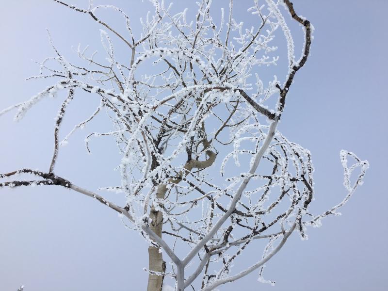
Rime, caused by moisture from the air refreezing onto the windward side of these aspen branches. (Pagnocco 2-5-2016)
|
 |
recent activity
***To view our updated list of backcountry observations and avalanche activity from around Utah, go to our observations page
|
| type | aspect/elevation | characteristics |
|---|

|
|
LIKELIHOOD
 LIKELY
UNLIKELY
SIZE
 LARGE
SMALL
TREND
 INCREASING DANGER
SAME
DECREASING DANGER
|
|
description
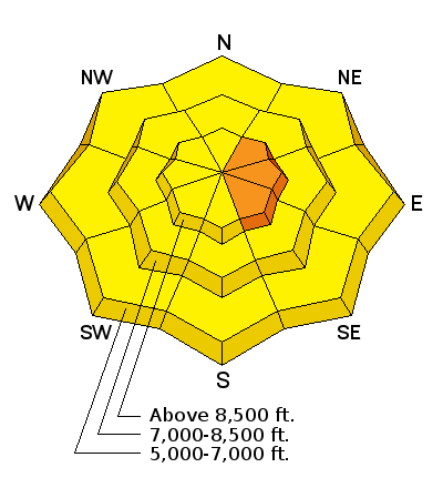
West wind increased a bit overnight drifting the fresh light snow in exposed terrain, and you are likely to trigger fresh wind slab avalanches on some steep drifted slopes at upper elevations.
|
| type | aspect/elevation | characteristics |
|---|

|

|
LIKELIHOOD
 LIKELY
UNLIKELY
SIZE
 LARGE
SMALL
TREND
 INCREASING DANGER
SAME
DECREASING DANGER
|
|
description
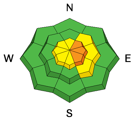
A lingering possibility of triggering a dangerous deep slab avalanche exists in outlying terrain and on isolated slopes with shallow snow cover. The slopes we are concerned with have poor snow structure. Weak sugary or faceted snow near the ground overloaded by a slab layer of harder snow creates a potentially unstable situation. Beware areas that avalanched earlier in the winter, since weak snow remained in the bed surfaces and the areas remained shallow. Weak snow structure exists mainly in areas where the total snow is 3' deep or less. Deep avalanches are most likely in shallow rocky upper elevation terrain, but the shallow snow is still also weak in many areas at lower and mid elevations. I'm finding propagation in many of my snowpit tests in shallower snow, but the results are less consistent.
|
| type | aspect/elevation | characteristics |
|---|

|
|
LIKELIHOOD
LIKELY
UNLIKELY
SIZE
LARGE
SMALL
TREND
INCREASING DANGER
SAME
DECREASING DANGER
|
|
description
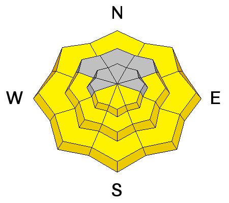
As the fresh powder is warmed by direct sun or possible greenhousing today, it'll become moist and may be prone to sluffing on steep slopes. Natural loose wet avalanches may become likely if temperatures rise rapidly, and avalanches might be initiated by snow falling off rocks or trees onto steep slopes below. Roller balls or shallow sluffs indicate the potential and increasing danger of wet avalanches. Loose wet sluffs could gouge down and include significant snow in descent. If the snow you're in starts to become sticky and moist you should avoid steep slopes and head to somewhere less steep or more shady. |
 |
weather Expect a warming trend and increasingly fair weather in the mountains as a strong high pressure system begins to build into the region. It'll be partly sunny in the mountains today, with a high temperature at 8500' of around 31 degrees and 15 to 20 mph westerly winds on the ridges. Winds will shift from the northwest and increase a little tonight and it'll be mostly cloudy with a low temperature of around 18 degrees. It'll be mostly sunny tomorrow, with a high temperature around 31 degrees... Looks like the high will only gain strength as we head into next week and the weather will be nice, sunny, and mild in the mountains while the dreaded smog and haze builds in the valleys. |
| general announcements Please submit snow and avalanche observations from your ventures in the backcountry HERE. You can call us at 801-524-5304 or email HERE, or include #utavy in your Instagram or Tweet us @UAClogan. To report avalanche activity in the Logan Area or to contact the local avalanche forecaster call me, Toby, at 435-757-7578. I'll update this advisory throughout the season on Monday, Wednesday, Friday, and Saturday mornings by about 7:30 This advisory is produced by the U.S.D.A. Forest Service, which is solely responsible for its content. It describes only general avalanche conditions and local variations always exist. |