| Please join us at the 23rd annual Black Diamond Fall Fundraiser Party Thursday Sept 15. Tickets are on sale now here, at the Black Diamond store & at REI. Special bonus raffle for online ticket purchasers! |
| Please join us at the 23rd annual Black Diamond Fall Fundraiser Party Thursday Sept 15. Tickets are on sale now here, at the Black Diamond store & at REI. Special bonus raffle for online ticket purchasers! |
| Advisory: Logan Area Mountains | Issued by Toby Weed for Friday - February 5, 2016 - 7:00am |
|---|

|
bottom line MODERATE (level 2): Heightened avalanche conditions exist in the backcountry. Evaluate the snow and terrain carefully and make conservative decisions. Wind slab avalanches are likely in drifted upper elevation terrain where the danger is higher (level 3), and you could still trigger dangerous deep slab avalanches on some slopes steeper than about 30 degrees in isolated areas where a harder slab layer is overloading weak sugary or faceted snow near the ground.
|
 |
current conditions There's 8 inches of light new powder from the last 24 hous, and the temperature is 12 degrees this morning at the 8400' Tony Grove Snotel. There's 82 inches of total snow, containing 108% of average water content for the date. The 9700' CSI Logan Peak weather station reports 10 degrees and steady 10 to 15 mph wind from the northwest.
|
 |
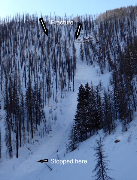
recent activity A solo backcountry skier was tragically killed by an avalanche near Park City on Sunday and his body recovered Tuesday. Here is our Accident Report. A Forest Service Utah Avalanche Center backcountry avalanche forecaster was caught, carried, partially buried and injured in a nasty deep slab avalanche in the Skyline Zone on Wednesday(2-3-16.) Accident Report
A FS Utah Avalanche Center avalanche forecaster was luckily only injured in this nasty deep slab avalanche in the Skyline backcountry Wednesday, 2-3-16.
***To view our updated list of backcountry observations and avalanche activity from around Utah, go to our observations page
|
| type | aspect/elevation | characteristics |
|---|

|
|
LIKELIHOOD
 LIKELY
UNLIKELY
SIZE
 LARGE
SMALL
TREND
 INCREASING DANGER
SAME
DECREASING DANGER
|
|
description
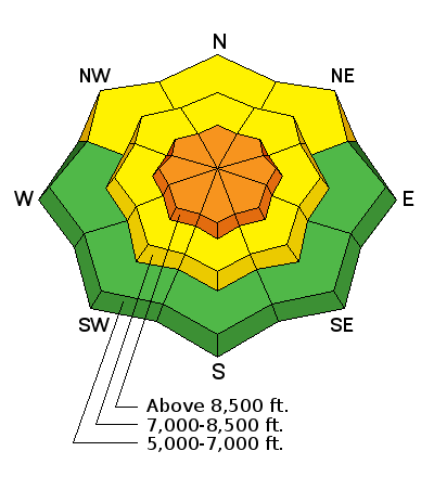
Moderate but sustained northwest wind overnight drifted yesterday's light snow in exposed terrain, and you are likely to trigger fresh wind slab avalanches on steep drifted slopes in deposition zones at upper elevations.
|
| type | aspect/elevation | characteristics |
|---|

|
|
LIKELIHOOD
 LIKELY
UNLIKELY
SIZE
 LARGE
SMALL
TREND
INCREASING DANGER
SAME
DECREASING DANGER
|
|
description
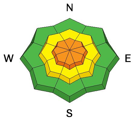
A lingering possibility of triggering a dangerous deep slab avalanche exists in outlying terrain and on isolated slopes with shallow snow cover. The slopes we are concerned with have poor snow structure. Weak sugary or faceted snow near the ground overloaded by a slab layer of harder snow creates a potentially unstable situation. Beware areas that avalanched earlier in the winter, since weak snow remained in the bed surfaces and the areas remained shallow. Weak snow structure exists mainly in areas where the total snow is 3' deep or less. Avalanches are most likely in shallow rocky upper elevation terrain, but the shallow snow is still also weak in many areas at lower and mid elevations. I'm finding propagation in most of my snowpit tests in shallower snow this week, with failures common in loose sugary faceted snow in the basal layers. ***Pay close attention to signs of unstable snow like recent avalanches, whumpfing, and shooting cracks, and be willing to reevaluate your plans. In these conditions you could trigger avalanches remotely, from a distance or worse, from below!
|
 |
weather The final system in the recent stream of storms is heading off to the east this morning and a strong high pressure system will build over the area. High pressure will become quite strong over the entire region this weekend and through early next week. It'll be mostly cloudy today with isolated snow showers possible, moderate northwest wind, and a high temperature at 8500' around 21 degrees. The sun may pop out occasionally. It'll be mostly cloudy tonight, and warmer tomorrow, with a high temperature around 27 degrees. |
| general announcements Please submit snow and avalanche observations from your ventures in the backcountry HERE. You can call us at 801-524-5304 or email HERE, or include #utavy in your Instagram or Tweet us @UAClogan. To report avalanche activity in the Logan Area or to contact the local avalanche forecaster call me, Toby, at 435-757-7578. I'll update this advisory throughout the season on Monday, Wednesday, Friday, and Saturday mornings by about 7:30 This advisory is produced by the U.S.D.A. Forest Service, which is solely responsible for its content. It describes only general avalanche conditions and local variations always exist. |