| Please join us at the 23rd annual Black Diamond Fall Fundraiser Party Thursday Sept 15. Tickets are on sale now here, at the Black Diamond store & at REI. Special bonus raffle for online ticket purchasers! |
| Please join us at the 23rd annual Black Diamond Fall Fundraiser Party Thursday Sept 15. Tickets are on sale now here, at the Black Diamond store & at REI. Special bonus raffle for online ticket purchasers! |
| Advisory: Logan Area Mountains | Issued by Toby Weed for Friday - January 29, 2016 - 7:15am |
|---|

|
bottom line CONSIDERABLE (level 3): You are likely to trigger wind slab avalanches today in drifted upper elevation terrain. Careful snowpack evaluation, cautious routefinding, and conservative decision-making will be essential in the backcountry. Heavy snow, strong winds, and perhaps a bit of rain-on-snow will probably cause the avalanche danger to rise significantly this afternoon and overnight. Expect dangerous conditions to develop, with overnight natural activity possible, dangerous triggered avalanches likely, and perhaps a HIGH danger tomorrow.
|
 |
avalanche watch THE FOREST SERVICE UTAH AVALANCHE CENTER IN SALT LAKE CITY HAS ISSUED A BACKCOUNTRY AVALANCHE WATCH. * TIMING...IN EFFECT FROM 6 AM THIS MORNING UNTIL 6 AM SATURDAY. * AFFECTED AREA...FOR THE MOUNTAINS OF NORTHERN AND CENTRAL UTAH AND SOUTHEASTERN IDAHO INCLUDING THE WASATCH RANGE...BEAR RIVER RANGE...WESTERN UINTA RANGE...AND MANTI SKYLINE PLATEAU. * AVALANCHE DANGER...THE AVALANCHE DANGER IS EXPECTED TO RISE TO HIGH WITHIN THE NEXT 24 HOURS. * IMPACTS...BY SATURDAY MORNING EXPECTED HEAVY SNOWFALL AND STRONG WINDS WILL CREATE WIDESPREAD AREAS OF UNSTABLE SNOW. BOTH HUMAN TRIGGERED AND NATURAL AVALANCHES WILL BE LIKELY. BACKCOUNTRY TRAVELERS SHOULD CONSULT WWW.UTAHAVALANCHECENTER.ORG OR CALL 1-888-999-4019 FOR MORE DETAILED INFORMATION. THIS WATCH DOES NOT APPLY TO SKI AREAS WHERE AVALANCHE HAZARD REDUCTION MEASURES ARE PERFORMED. |
 |
current conditions The temperature is 26 degrees and there's five inches of new snow this morning at the 8400' Tony Grove Snotel. I'm reading 68 inches of total snow, containing 101% of average water content for the date. The 9700' CSI Logan Peak weather station reports 19 degrees and westerly winds overnight, currently averaging about 15 mph. We've found pretty nice powder riding conditions locally in the past few days, but heavy snow and winds from a moist and powerful Pacific storm will cause increasing avalanche danger in the backcountry as we head into the weekend.
|
 |
recent activity
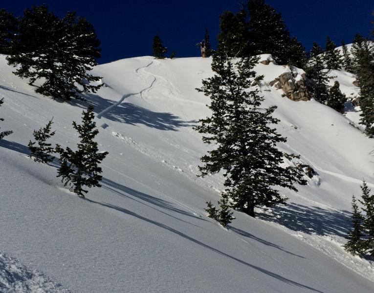
A skier triggered and then escaped this shallow wind slab avalanche in Wildcat Bowl in the Wood Camp Area on Wednesday (1-27-16). Several other similar (apparently manageable) avalanches were triggered by people locally in the past few days.
***To view our updated list of backcountry observations and avalanche activity from around Utah, go to our observations page
|
| type | aspect/elevation | characteristics |
|---|

|
|
LIKELIHOOD
 LIKELY
UNLIKELY
SIZE
 LARGE
SMALL
TREND
 INCREASING DANGER
SAME
DECREASING DANGER
|
|
description
There were several triggered wind slab avalanches in the past few days locally, and last night's snow and a bump in west winds drifted snow into lee slopes and deposition areas. Watch for and avoid recent drifts and/or wind slabs near ridge tops and in and around terrain features like gullies, sub-ridges, scoops, and rock outcroppings.
|
| type | aspect/elevation | characteristics |
|---|

|

|
LIKELIHOOD
 LIKELY
UNLIKELY
SIZE
 LARGE
SMALL
TREND
INCREASING DANGER
SAME
DECREASING DANGER
|
|
description
Soft storm slab avalanches will become increasingly possible as new snow piles up on existing weak surface snow. We've noticed the development of small sugary faceted snow and areas with feathery surface hoar on the snow surface in the past few days. If the weak surface snow was buried intact overnight, or perhaps today, before being destroyed by warmth, rain, or wind, it is likely to become a failing layer for storm slabs and probably also a longer lasting persistent weak layer.
|
| type | aspect/elevation | characteristics |
|---|

|
|
LIKELIHOOD
 LIKELY
UNLIKELY
SIZE
 LARGE
SMALL
TREND
INCREASING DANGER
SAME
DECREASING DANGER
|
|
description
Heavy new snow, maybe rain, and strong winds will overload a complex snowpack, with existing buried persistent weak layers in some areas and basal layer depth hoar in others.
***Pay close attention to signs of unstable snow like recent avalanches, whumpfing, and shooting cracks, and be willing to reevaluate your plans. In these conditions you could trigger avalanches remotely, from a distance or worse, from below!
|
 |
weather The National Weather Service has issued a Winter Storm Warning for the mountains in the Logan Zone. The storm will begin this afternoon with snow and increasing southwest wind. Expect snowfall to continue overnight and intensify with tomorrow mornings frontal passage.
|
| general announcements The CROWBAR backcountry ski race will be Saturday January 30. More info at http://CrowbarSkiRace.org. Please submit snow and avalanche observations from your ventures in the backcountry HERE. You can call us at 801-524-5304 or email HERE, or include #utavy in your Instagram or Tweet us @UAClogan. To report avalanche activity in the Logan Area or to contact the local avalanche forecaster call me, Toby, at 435-757-7578. I'll update this advisory throughout the season on Monday, Wednesday, Friday, and Saturday mornings by about 7:30 This advisory is produced by the U.S.D.A. Forest Service, which is solely responsible for its content. It describes only general avalanche conditions and local variations always exist. |