
| During the month of April, Mark Miller will donate $75 to the charity of your choice (5 to chose from, including the Utah Avalanche Center!) Mark Miller Subaru has raised over $300k in the previous 6 Do Good Feel Good events. More Info here |  |
| During the month of April, Mark Miller will donate $75 to the charity of your choice (5 to chose from, including the Utah Avalanche Center!) Mark Miller Subaru has raised over $300k in the previous 6 Do Good Feel Good events. More Info here | |
| Advisory: Logan Area Mountains | Issued by Toby Weed for Monday - March 16, 2015 - 6:42am |
|---|

|
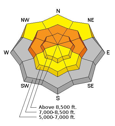
bottom line CONSIDERABLE (level 3): Heightened wet avalanche conditions exist on many slopes in the backcountry. After yet another warm night without a refreeze, unseasonably hot temperatures again today could create dangerous conditions, with triggered avalanches likely on steep slopes with saturated snow, and natural loose wet, wet slab, cornice fall, and glide avalanches possible.
|
 |
special announcement
|
 |
current conditions Heightened wet avalanche conditions exist in the backcountry, and with very warm temperatures today and lacking an overnight refreeze again, conditions could easily become downright dangerous on some steep slopes by mid-afternoon. The Tony Grove Snotel reports 62 inches of total snow containing 88% of average water for the date. Temperatures did not drop below freezing last night and at 2:00 this morning it was 46 degrees at 8400'. Currently I'm reading 39 degrees at the 9700' CSI Logan Peak weather station. It's a bit cooler lower down in the Middle Sinks Area, with 36 degrees posted at the UDOT Hwy 89 Logan Summit, and light easterly winds overnight.
|
 |
recent activity
|
| type | aspect/elevation | characteristics |
|---|

|
|
LIKELIHOOD
 LIKELY
UNLIKELY
SIZE
 LARGE
SMALL
TREND
 INCREASING DANGER
SAME
DECREASING DANGER
|
|
description
Natural wet loose and wet slab avalanches are possible again in steep terrain today, and triggered avalanches are likely, especially during the afternoon heat. Dangerous wet slab avalanches are possible at mid and upper elevations on slopes with poor snow structure, especially in outlying areas like the Wellsville Mountain and Mt. Naomi Wildernesses, and in "extreme" or "serious" mountain terrain. This is certainly not a good day for mountaineering, and you should tone down any plans that might include travel on or under steep mountain slopes. Avoid shallow or rocky areas with saturated snow and ridge-top cornices which are starting to sag, buckle, and fail in the warmth.
|
 |
weather It'll be partly cloudy and warm in the mountains, with a high temperature at 9000' around 53 degrees and moderate southwest winds diminishing by afternoon. It'll be mostly cloudy tonight with a low temperature around 42 degrees and southeast winds picking up a bit after midnight. It'll be cloudy tomorrow, with high temperatures in the mid fifties again and increasing moderate southeast wind. There's a chance for some rain or snow showers in the afternoon and thunder storms are possible, but little in the way of accumulation is expected. Unsettled and mild weather will continue through mid-week, with clearing expected around Thursday. ***Check out our one-stop weather page........HERE
|
| general announcements ***Advisories by email for the Logan Zone. Go here for details. *** Utah Avalanche Center mobile app Discount lift tickets are now available at Backcountry.com. Thanks to Ski Utah and the Utah Resorts. All proceeds go towards paying for Utah Avalanche Center avalanche and mountain weather advisories. Benefit the Utah Avalanche Center when you shop from Backcountry.com or REI: Click this link for Backcountry.com or this link to REI, shop, and they will donate a percent of your purchase price to the UAC. Both offer free shipping (with some conditions) so this costs you nothing! ***Please submit snow and avalanche observations from your ventures in the backcountry HERE. You can call us at 801-524-5304 or email HERE, or include #utavy in your Instagram or Tweet us @UAClogan. To report avalanche activity in the Logan Area or to contact the local avalanche forecaster call me, Toby, at 435-757-7578. I'll regularly update this advisory on Monday, Wednesday, Friday, and Saturday mornings by about 7:30. This advisory is produced by the U.S.D.A. Forest Service, which is solely responsible for its content. It describes only general avalanche conditions and local variations always exist. |


_1.jpg)