| During the month of April, Mark Miller will donate $75 to the charity of your choice (5 to chose from, including the Utah Avalanche Center!) Mark Miller Subaru has raised over $300k in the previous 6 Do Good Feel Good events. More Info here |  |

For every car Mark MIller Subaru sells in April, they will donate $75 to the charity of your choice (5 to choose from). Who are you going to choose? Plus - you can vote for your favorite and the 3 groups receiving the most votes get an additional cash prize donated by Mark Miller Subaru. Details here

| During the month of April, Mark Miller will donate $75 to the charity of your choice (5 to chose from, including the Utah Avalanche Center!) Mark Miller Subaru has raised over $300k in the previous 6 Do Good Feel Good events. More Info here |  |
| Advisory: Logan Area Mountains | Issued by Toby Weed for Tuesday - March 3, 2015 - 6:55am |
|---|
 |
special announcement ****Special thanks to Buttar's of Tremonton and ArcticCat for hooking us up with the light and powerful M8000, which is featured in UAC Logan's Practicing Companion Rescue video........HERE
|
 |
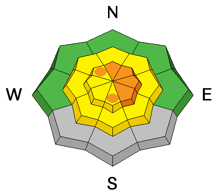
current conditions The Tony Grove Snotel reports 6 inches of new snow and 0.4" of water in the last 24 hours. There's 74 inches of total snow containing 93% of average water for the date, and it's 20 degrees at 8400 feet. It's 21 degrees at the UDOT Hwy 89 Logan Summit weather station, with west-northwest wind sustaining wind speeds in the teens and gusting into the twenties overnight. Heightened avalanche conditions exist in the backcountry, and with several inches of accumulation possible and sustained northwest wind forecast, dangerous storm snow avalanche conditions could well develop at upper elevations during the day today.
A gargoyle of drought, a remnant stump of the 1994 Beaver Fire leering over the Bear River Range. 3-1-2015
|
 |
recent activity No avalanches were reported locally since the first week of February, but I've noticed some small natural wind slab releases in obviously drifted areas.
Small wind slab release visible from a distance on an obviously drifted slope down wind from a perfect fetch area in Amazon Basin. 3-1-2015 ***Visit our Backcountry Observations Page for more local information and from across the state.
|
| type | aspect/elevation | characteristics |
|---|


|


|

LIKELIHOOD
 LIKELY
UNLIKELY
SIZE
 LARGE
SMALL
TREND
 INCREASING DANGER
SAME
DECREASING DANGER
|
|
description
Expect a rising avalanche danger in the backcountry with several more inches of accumulating snow possible today. The suspect weak layer was on the surface this weekend. The thin layer of nice re-crystallized powder on the solid underlying crust will likely become an active weakness with a significant load of new snow. Storm slab avalanches will become more likely and the danger more widespread as more snow piles up. Natural avalanches are possible during periods of especially heavy snowfall. Even small or shallow avalanches could run far and fast on solid and slick bed surfaces. Avoid freshly built cornices and wind deposited snow on the lee side of ridges, in and around terrain features like gullies and cliff bands, and areas where snow is vertically cross-loaded near sub-ridges, roll-overs, or scoops lower on the slope.
|
 |
weather Snow showers will continue today, with 5 to 9 inches of additional accumulation possible. Expect high temperatures at 8500 feet around 19 degrees and sustained northwest winds in the 15 to 20 mph range on the ridges. Scattered showers will continue tonight, but little accumulation is expected. Tonight's low temperature will drop to around 3 degrees, plunging the wind chill down to around -15 degrees, it'll be mostly cloudy with a 10 to 20 mph north wind. It'll be mostly sunny tomorrow with a high of around 18 degrees and moderate north winds. ***Check out our one-stop weather page........HERE
|
| general announcements ***Advisories by email for the Logan Zone. Go here for details. *** Utah Avalanche Center mobile app Discount lift tickets are now available at Backcountry.com. Thanks to Ski Utah and the Utah Resorts. All proceeds go towards paying for Utah Avalanche Center avalanche and mountain weather advisories. Benefit the Utah Avalanche Center when you shop from Backcountry.com or REI: Click this link for Backcountry.com or this link to REI, shop, and they will donate a percent of your purchase price to the UAC. Both offer free shipping (with some conditions) so this costs you nothing! ***Please submit snow and avalanche observations from your ventures in the backcountry HERE. You can call us at 801-524-5304 or email HERE, or include #utavy in your Instagram or Tweet us @UAClogan. To report avalanche activity in the Logan Area or to contact the local avalanche forecaster call me, Toby, at 435-757-7578. I'll regularly update this advisory on Monday, Wednesday, Friday, and Saturday mornings by about 7:30. This advisory is produced by the U.S.D.A. Forest Service, which is solely responsible for its content. It describes only general avalanche conditions and local variations always exist. |
Advisory Hotline: (888) 999-4019 | Contact Information