| During the month of April, Mark Miller will donate $75 to the charity of your choice (5 to chose from, including the Utah Avalanche Center!) Mark Miller Subaru has raised over $300k in the previous 6 Do Good Feel Good events. More Info here |  |
| During the month of April, Mark Miller will donate $75 to the charity of your choice (5 to chose from, including the Utah Avalanche Center!) Mark Miller Subaru has raised over $300k in the previous 6 Do Good Feel Good events. More Info here | |
| Advisory: Logan Area Mountains | Issued by Toby Weed for Sunday - February 22, 2015 - 7:12am |
|---|

|
bottom line Although the snow remains stable on most slopes in the backcountry, drifting fresh snow from sustained southeast wind overnight created a MODERATE or (Level 2) danger at upper elevations. Heightened wind slab avalanche conditions exist on some drifted slopes, and triggered avalanches are possible.
|
 |
special announcement
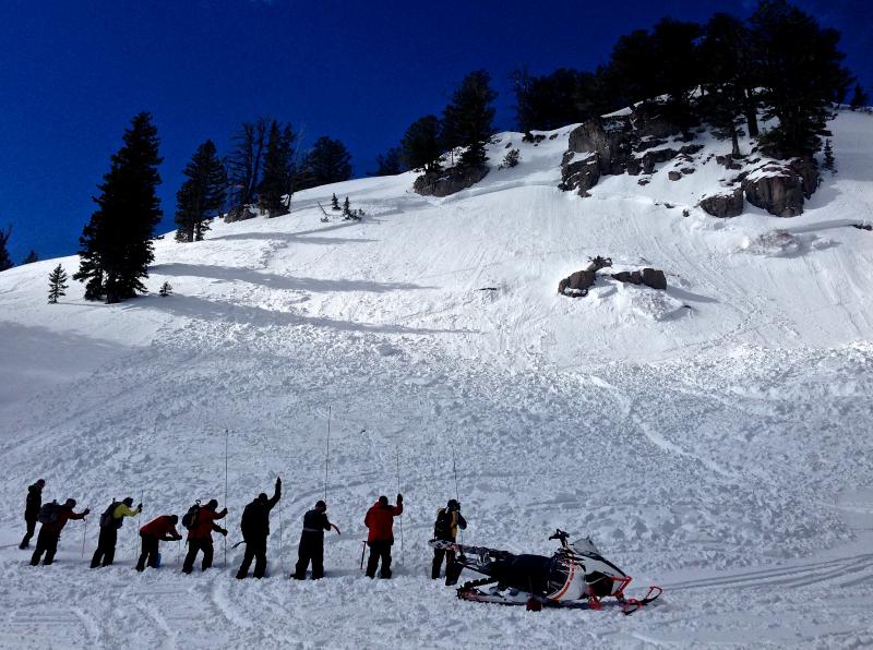
Practicing avalanche rescue in debris from a fresh sled-triggered avalanche up at Tony Grove. (2-7-15) *****Special thanks to Buttar's of Tremonton and ArcticCat for hooking us up with the light and powerful M8000, which is featured in UAC Logan's Practicing Companion Rescue video........HERE
|
 |
current conditions The Bear River Range picked up a few inches of fresh snow Friday night, which freshened up riding conditions significantly. You'll find nice dust-on-crust riding conditions, with the best shallow powder at upper elevations on slopes facing the north quarter of the compass. The Tony Grove Snotel reports 72 inches of total snow containing 100% of average water for the date, and it's 7 degrees at the 8400' site. The UDOT Hwy 89 Logan Summit weather station reports 8 degrees, and southeast winds gusting into the mid-twenties overnight and continuing this morning. ***Observation Video from Steep Hollow on 2-20-2015, in which I found pooled graupel under the cliffs.........HERE
|
 |
recent activity No avalanches were reported locally since the first week of February. Visit our Backcountry Observations Page for more local information and from across the state.
|
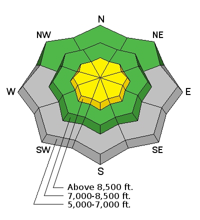
| type | aspect/elevation | characteristics |
|---|

|
|
LIKELIHOOD
 LIKELY
UNLIKELY
SIZE
 LARGE
SMALL
TREND
 INCREASING DANGER
SAME
DECREASING DANGER
|
|
description
Triggered wind slab avalanches up to around a foot deep are possible in drifted upper elevation terrain. Southeast winds increased overnight and will continue today, stripping the light fresh snow from large low angled fetch areas and depositing it into lee slope avalanche starting zones. Avoid stiffer, wind deposited snow on the lee side of major ridges, in and around terrain features like gullies and cliff bands, and vertically cross-loaded near sub-ridges, roll-overs, or scoops lower on the slope.
|
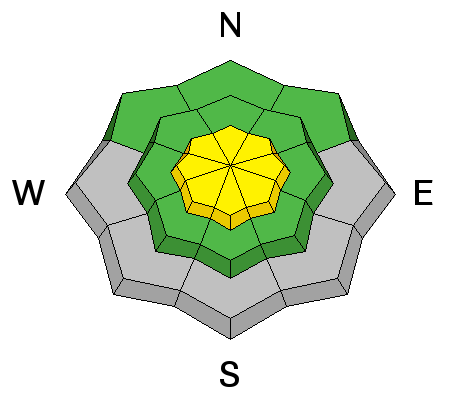
| type | aspect/elevation | characteristics |
|---|

|
|
LIKELIHOOD
LIKELY
UNLIKELY
SIZE
LARGE
SMALL
TREND
INCREASING DANGER
SAME
DECREASING DANGER
|
|
description
Avoid freshly built-out cornices on major ridge-lines, which could break further back than you expect and might trigger wind slab avalanches on drifted slopes below.
|
 |
weather It'll be mostly sunny, but cold and windy in the mountains today, with 8500' high temperatures around 16 degrees and sustained and strong east winds, (averaging in the upper twenties and gusting into the 40s). Wind chills will be a good way below zero, which might be a bit of a shock to your system after our recent warm spell. Expect partly cloudy skies overnight with continuing strong east winds and single digit temperatures. Our next chance for some snow will come around midweek. ***Check out our one-stop weather page........HERE
|
| general announcements ***Advisories by email for the Logan Zone. Go here for details. *** Utah Avalanche Center mobile app Discount lift tickets are now available at Backcountry.com. Thanks to Ski Utah and the Utah Resorts. All proceeds go towards paying for Utah Avalanche Center avalanche and mountain weather advisories. Benefit the Utah Avalanche Center when you shop from Backcountry.com or REI: Click this link for Backcountry.com or this link to REI, shop, and they will donate a percent of your purchase price to the UAC. Both offer free shipping (with some conditions) so this costs you nothing! ***Please submit snow and avalanche observations from your ventures in the backcountry HERE. You can call us at 801-524-5304 or email HERE, or include #utavy in your Instagram or Tweet us @UAClogan. To report avalanche activity in the Logan Area or to contact the local avalanche forecaster call me, Toby, at 435-757-7578. I'll regularly update this advisory on Monday, Wednesday, Friday, and Saturday mornings by about 7:30. This advisory is produced by the U.S.D.A. Forest Service, which is solely responsible for its content. It describes only general avalanche conditions and local variations always exist. |


_1.jpg)