| During the month of April, Mark Miller will donate $75 to the charity of your choice (5 to chose from, including the Utah Avalanche Center!) Mark Miller Subaru has raised over $300k in the previous 6 Do Good Feel Good events. More Info here |  |
| During the month of April, Mark Miller will donate $75 to the charity of your choice (5 to chose from, including the Utah Avalanche Center!) Mark Miller Subaru has raised over $300k in the previous 6 Do Good Feel Good events. More Info here | |
| Advisory: Logan Area Mountains | Issued by Toby Weed for Friday - February 20, 2015 - 7:01am |
|---|

|
bottom line Avalanches are unlikely, and the danger is LOW (or level 1) in the backcountry.
|
 |
special announcement
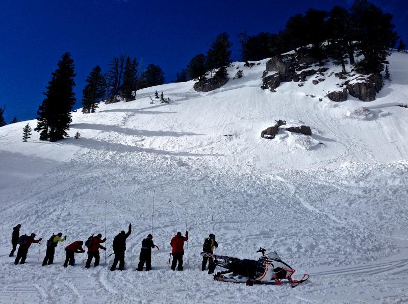
Practicing avalanche rescue in debris from a fresh sled-triggered avalanche up at Tony Grove. (2-7-15) *****Special thanks to Buttar's of Tremonton and ArcticCat for hooking us up with the light and powerful M8000, which is featured in UAC Logan's Practicing Companion Rescue video........HERE
|
 |
current conditions Looks like we might see a little snow in the mountains today, but there isn't much in the way of powder in the backcountry after a prolonged period of warm weather. You'll find supportable, spring-like snow on most slopes in the backcountry this morning, which will likely not soften up much due to clouds and wind today. Despite the recent mild weather, observers report finding pockets of nice re-crystallized soft snow on due north facing upper elevation slopes. An inch or two of accumulation is quite possible and will help riding conditions significantly, but even a couple inches won't be enough to increase the avalanche danger much. The Tony Grove Snotel reports 67 inches of total snow containing 101% of average water for the date, and it's 31 degrees at the 8400' site. The UDOT Hwy 89 Logan Summit weather station reports 32 degrees, and 15 to 25 mph northwest wind overnight and continuing this morning.
|
 |
recent activity No avalanches were reported locally since the first week of February. Visit our Backcountry Observations Page for more local information and from across the state.
|
| type | aspect/elevation | characteristics |
|---|

|

|
LIKELIHOOD
 LIKELY
UNLIKELY
SIZE
 LARGE
SMALL
TREND
 INCREASING DANGER
SAME
DECREASING DANGER
|
|
description
The snow is stable and avalanches are unlikely. An inch or two of new snow isn't enough to cause an increase in danger, but shallow wind slabs will form fairly quickly at upper elevations, and more than expected accumulation could create heightened conditions in drifted terrain over the weekend. Other objective hazards to watch for in the mountains today include loss of control or slide-for-life potential in steep terrain on smooth and solidly refrozen snow, and hitting shallowly buried rocks or other hazards at mid and lower elevations. Minimize resource damage and avoid riding over sage and bare ground.
|
 |
weather Some accumulating snow is possible in the mountains today, with snow showers likely, and it'll be mostly cloudy with sustained west-northwest wind and 8500' high temperatures around 31 degrees. Snow showers will continue tonight, temperatures will drop into the mid teens, and an inch or two of accumulation is possible. Keep your fingers crossed, it looks like snow showers will again be likely tomorrow and tomorrow night, with 2 to 4 additional inches possible, and even an inch or two will help matters significantly. ***Check out our one-stop weather page........HERE
|
| general announcements ***Advisories by email for the Logan Zone. Go here for details. *** Utah Avalanche Center mobile app Discount lift tickets are now available at Backcountry.com. Thanks to Ski Utah and the Utah Resorts. All proceeds go towards paying for Utah Avalanche Center avalanche and mountain weather advisories. Benefit the Utah Avalanche Center when you shop from Backcountry.com or REI: Click this link for Backcountry.com or this link to REI, shop, and they will donate a percent of your purchase price to the UAC. Both offer free shipping (with some conditions) so this costs you nothing! ***Please submit snow and avalanche observations from your ventures in the backcountry HERE. You can call us at 801-524-5304 or email HERE, or include #utavy in your Instagram or Tweet us @UAClogan. To report avalanche activity in the Logan Area or to contact the local avalanche forecaster call me, Toby, at 435-757-7578. I'll regularly update this advisory on Monday, Wednesday, Friday, and Saturday mornings by about 7:30. This advisory is produced by the U.S.D.A. Forest Service, which is solely responsible for its content. It describes only general avalanche conditions and local variations always exist. |


_1.jpg)