| During the month of April, Mark Miller will donate $75 to the charity of your choice (5 to chose from, including the Utah Avalanche Center!) Mark Miller Subaru has raised over $300k in the previous 6 Do Good Feel Good events. More Info here |  |
| During the month of April, Mark Miller will donate $75 to the charity of your choice (5 to chose from, including the Utah Avalanche Center!) Mark Miller Subaru has raised over $300k in the previous 6 Do Good Feel Good events. More Info here | |
| Advisory: Logan Area Mountains | Issued by Toby Weed for Friday - February 13, 2015 - 7:11am |
|---|

|
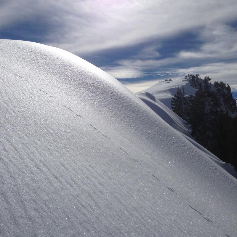
bottom line The snow is stable on most slopes, and the danger is LOW (level 1) in the backcountry. Avalanches are generally unlikely, but triggered persistent slab avalanches remain a possibility on isolated previously drifted slopes at upper elevations.
|
 |
special announcement Special thanks to Buttar's and ArcticCat for hooking us up with the light and powerful M8000. This machine will make our field days more fun, safe, and productive and will significantly boost our outreach and education efforts. RESEARCH PROJECT ON UNDERSTANDING TRAVEL BEHAVIOR IN AVALANCHE TERRAIN NEEDS YOU!! Scientists from the Snow and Avalanche Lab at Montana State University are seeking more participants for their project examining decision making and travel in avalanche terrain. Their project aims to collect GPS location information (from your smartphone) and survey responses from backcountry skiers and riders to better understand what types of terrain are used, and how decisions are made. Their focus is on backcountry skiers and riders of all abilities and experience. More information: If you want to participate, or learn more about their project aims, research questions and approaches, please visit their web page: www.montana.edu/snowscience/tracks or their companion site directed toward snowmobilers at: www.montana.edu/snowscience/sleds From nearby Afton Wyoming on Feb 7, Honey Badger vs Avalanche via YouTube featured videos...... HERE On that note, ***Check out UAC Logan's Practicing Companion Rescue video........HERE
|
 |
current conditions The Tony Grove Snotel reports 70 inches of total snow containing 113% of average water for the date. It's mighty warm this morning, already 38 degrees at the 8400' site. The UDOT Hwy 89 Logan Summit weather station reports 17 degrees this morning, light east winds winds overnight, and low daytime relative humidity in the past few days, bottoming out in the mid twenties yesterday. You can find nice shallow powder conditions at upper elevations and smooth dust-on-crust at mid elevations, but most lower elevation slopes, and the lower reaches of many trails are burned off and melted out.
Glittering frost or surface hoar near the ridge-top could become a persistent weak layer if it's buried intact and preserved. (2-11-2015)
|
 |
recent activity There were over a dozen sled triggered avalanches in the Tony Grove and White Pine Canyon areas last week, but the riders were able to escape injury. The avalanches failed on a thin weak layer above a rime-crust that has since gained considerable strength. Other recent local activity: Observers reported a couple natural cornice-fall/wind-slab avalanches which occurred at upper elevations in the Tony Grove and Bunch Grass Areas last Friday afternoon. Last week's Sled Triggered Slides up at the Grove from 2/6/15.....HERE Avalanche on Mt. Magog's South Ridge, 2/5/15....HERE Visit our Backcountry Observations Page for more local information and from across the state.
|
| type | aspect/elevation | characteristics |
|---|

|
|
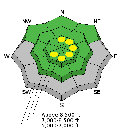
LIKELIHOOD
 LIKELY
UNLIKELY
SIZE
 LARGE
SMALL
TREND
 INCREASING DANGER
SAME
DECREASING DANGER
|
|
description
The snow is stable on most slopes, but triggered avalanches may remain possible in some steep drifted upper elevation terrain today. Hard slabs might allow you to get out on them before releasing. You should be wary around terrain features like cliff bands, sub-ridges, and gullies where wind slabs may have formed, and continue to suspect drifted slopes steeper than about 30 degrees at upper elevations.
|
| type | aspect/elevation | characteristics |
|---|

|

|
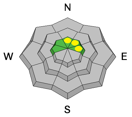
LIKELIHOOD
LIKELY
UNLIKELY
SIZE
LARGE
SMALL
TREND
INCREASING DANGER
SAME
DECREASING DANGER
|
|
description
Avalanches are generally unlikely, but are still possible, along with other objective hazards, in very steep or "extreme" mountain terrain. Continue to use safe travel protocols, go one-at-a-time while others in your party watch from safer areas, and carry and practice with your rescue equipment...
|
| type | aspect/elevation | characteristics |
|---|

|
|
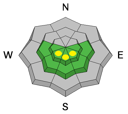
LIKELIHOOD
 LIKELY
UNLIKELY
SIZE
 LARGE
SMALL
TREND
 INCREASING DANGER
SAME
DECREASING DANGER
|
|
description
Loose wet avalanches involving saturated fresh surface snow are possible on steep sunny slopes during the warmth of midday.
|
 |
weather It'll be sunny and warm today, with high temperatures at 8500' around 47 degrees and light west winds on the ridge-tops. Expect partly cloudy conditions tonight, with a low temperature around 33 degrees and southwest winds increasing a bit. There's a chance for a little snowfall tomorrow night and Monday, but accumulations look insignificant at this point. There is some faint hope for a stronger storm late next week... Check out our one-stop weather page........HERE
|
| general announcements You can now receive advisories by email for the Logan Zone. Go here for details. Get your advisory on your iPhone along with great navigation and rescue tools, with our updated, Utah Avalanche Center mobile app Discount lift tickets are now available at Backcountry.com. Thanks to Ski Utah and the Utah Resorts. All proceeds go towards paying for Utah Avalanche Center avalanche and mountain weather advisories. Benefit the Utah Avalanche Center when you shop from Backcountry.com or REI: Click this link for Backcountry.com or this link to REI, shop, and they will donate a percent of your purchase price to the UAC. Both offer free shipping (with some conditions) so this costs you nothing! Benefit the Utah Avalanche Center when you buy or sell on ebay - set the Utah Avalanche Center as a favorite non-profit in your ebay account here and click on ebay gives when you buy or sell. You can choose to have your seller fees donated to the UAC, which doesn't cost you a penny. ***Please submit snow and avalanche observations from your ventures in the backcountry HERE. You can call us at 801-524-5304 or email HERE, or include #utavy in your Instagram or Tweet us @UAClogan. To report avalanche activity in the Logan Area or to contact the local avalanche forecaster call me, Toby, at 435-757-7578. I'll regularly update this advisory on Monday, Wednesday, Friday, and Saturday mornings by about 7:30. This advisory is produced by the U.S.D.A. Forest Service, which is solely responsible for its content. It describes only general avalanche conditions and local variations always exist. |


_1.jpg)