| During the month of April, Mark Miller will donate $75 to the charity of your choice (5 to chose from, including the Utah Avalanche Center!) Mark Miller Subaru has raised over $300k in the previous 6 Do Good Feel Good events. More Info here |  |
| During the month of April, Mark Miller will donate $75 to the charity of your choice (5 to chose from, including the Utah Avalanche Center!) Mark Miller Subaru has raised over $300k in the previous 6 Do Good Feel Good events. More Info here | |
| Advisory: Logan Area Mountains | Issued by Toby Weed for Saturday - February 7, 2015 - 7:02am |
|---|

|
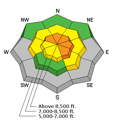
bottom line Dangerous conditions exist on drifted slopes and there's a CONSIDERABLE (level 3) danger at upper elevations in the backcountry. Dangerous triggered wind slab and cornice fall avalanches are possible on slopes steeper than about 30 degrees, especially in drifted terrain facing north through east above about 8500'.
|
 |
special announcement ****NEW VIDEO: this week's Sled Triggered Slides up at the Grove from 2/6/15........HERE On that note, ***Check out our Practicing Companion Rescue video........HERE
|
 |
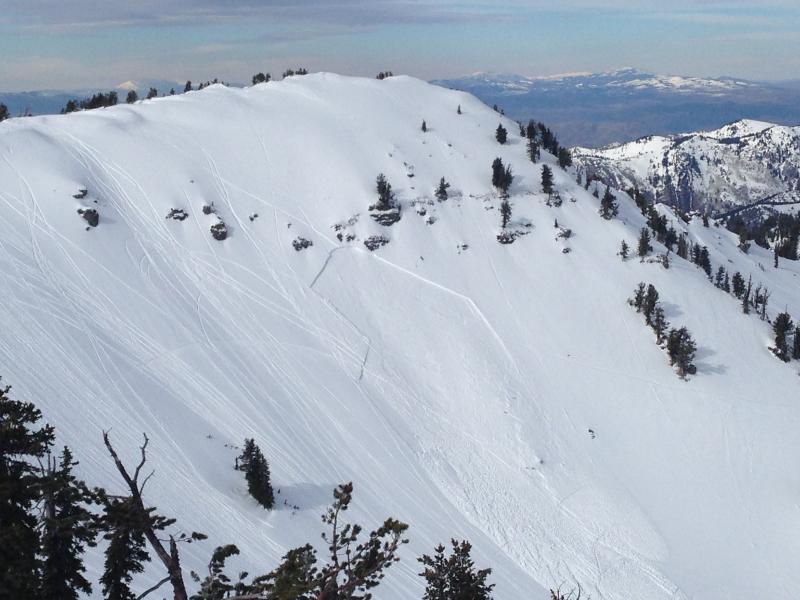
current conditions While it rained down low, it snowed up high this week, and the Tony Grove Snotel reports a new load with 5" of snow water equivalent since February 2. There's 72 inches of total snow containing 117% of average water for the date and it's a balmy 42 degrees this morning at the 8400' site. The UDOT Hwy 89 Logan Summit weather station reports 42 degrees this morning and increasing west-southwest winds overnight. Note southwest winds on Mt. Ogden topping out at around 70 mph overnight. Heavy new snow and strong winds earlier in the week created dangerous avalanche conditions at upper elevations, with multiple impressive sled triggered slides Wednesday and Thursday in the Tony Grove Area. It's way too warm! Melt has taken a serious toll, and mid elevation snow and any remaining lower elevation snow is saturated throughout . A sled triggered avalanche in Christmas Tree Bowl near Naomi Peak. (2-6-2015)
|
 |
recent activity There were over a dozen sled triggered avalanches in the Tony Grove and White Pine Canyon areas Wednesday and Thursday, and luckily nobody got hurt. The somewhat slow moving and "user friendly" avalanches were about 2 feet deep and some quite wide. The weak layer in this case consists of small sugary, near surface facets and in places, a bit of graupel. The thin layer of weak snow was on the surface at the end of January, and the avalanches are failing and running on top of a rime-crust from 1/24/15. Observers sighted a small natural cornice fall/wind slab avalanche off Cornice Ridge yesterday afternoon. Visit our Backcountry Observations Page for more local information and from across the state.
|
| type | aspect/elevation | characteristics |
|---|

|
|
LIKELIHOOD
 LIKELY
UNLIKELY
SIZE
 LARGE
SMALL
TREND
 INCREASING DANGER
SAME
DECREASING DANGER
|
|
description
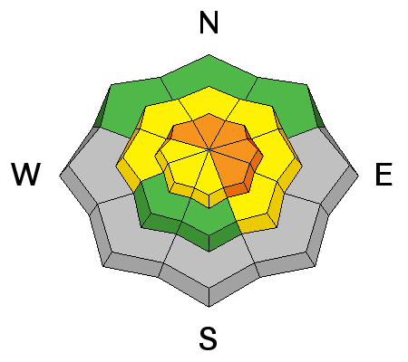
Sustained southwest winds are drifting snow into lee slope starting zones at upper elevations, and dangerous avalanche conditions continue to exist in drifted terrain. Triggered wind slab avalanches 2 to 3 feet deep are possible on some drifted upper elevation slopes today, and are most likely on north and especially east facing slopes. You should be wary around terrain features like cliff bands, sub-ridges, and gullies where wind slabs may have formed, and continue to avoid drifted slopes steeper than about 30 degrees at upper elevations.
|
| type | aspect/elevation | characteristics |
|---|

|
|
LIKELIHOOD
LIKELY
UNLIKELY
SIZE
LARGE
SMALL
TREND
INCREASING DANGER
SAME
DECREASING DANGER
|
|
description
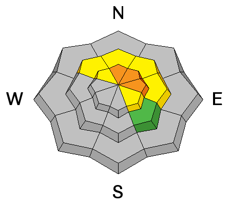
Avoid recently built ridge-top cornices, which might break further back than you expect and could trigger avalanches on steep slopes below. Natural cornice fall avalanches are possible in some areas as drifting continues with strong southwest wind today.
|
 |
weather It'll be cloudy and warm today in the mountains, with increasing and strong southwest winds, snow showers, and 8500' high temperatures around 44 degrees. Expect mostly cloudy conditions tonight with a low temperature around 32 degrees and less than an inch of snow expected. Snow showers are expected to continue in the mountains through the weekend, but our next chance for a few inches of accumulation comes on Monday. Check out our one-stop weather page........HERE
|
| general announcements Special thanks to Buttar's and ArcticCat for hooking us up with the light and powerful M8000. This machine will make our field days more fun, safe, and productive and will significantly boost our outreach and education efforts. RESEARCH PROJECT ON UNDERSTANDING TRAVEL BEHAVIOR IN AVALANCHE TERRAIN NEEDS YOU!! Scientists from the Snow and Avalanche Lab at Montana State University are seeking more participants for their project examining decision making and travel in avalanche terrain. Their project aims to collect GPS location information (from your smartphone) and survey responses from backcountry skiers and riders to better understand what types of terrain are used, and how decisions are made. Their focus is on backcountry skiers and riders of all abilities and experience. More information: If you want to participate, or learn more about their project aims, research questions and approaches, please visit their web page: www.montana.edu/snowscience/tracks or their companion site directed toward snowmobilers at: www.montana.edu/snowscience/sleds You can now receive advisories by email for the Logan Zone. Go here for details. Get your advisory on your iPhone along with great navigation and rescue tools, with our updated, Utah Avalanche Center mobile app Discount lift tickets are now available at Backcountry.com. Thanks to Ski Utah and the Utah Resorts. All proceeds go towards paying for Utah Avalanche Center avalanche and mountain weather advisories. Benefit the Utah Avalanche Center when you shop from Backcountry.com or REI: Click this link for Backcountry.com or this link to REI, shop, and they will donate a percent of your purchase price to the UAC. Both offer free shipping (with some conditions) so this costs you nothing! Benefit the Utah Avalanche Center when you buy or sell on ebay - set the Utah Avalanche Center as a favorite non-profit in your ebay account here and click on ebay gives when you buy or sell. You can choose to have your seller fees donated to the UAC, which doesn't cost you a penny. ***Please submit snow and avalanche observations from your ventures in the backcountry HERE. You can call us at 801-524-5304 or email HERE, or include #utavy in your Instagram or Tweet us @UAClogan. To report avalanche activity in the Logan Area or to contact the local avalanche forecaster call me, Toby, at 435-757-7578. I'll regularly update this advisory on Monday, Wednesday, Friday, and Saturday mornings by about 7:30. This advisory is produced by the U.S.D.A. Forest Service, which is solely responsible for its content. It describes only general avalanche conditions and local variations always exist. |


_1.jpg)