| During the month of April, Mark Miller will donate $75 to the charity of your choice (5 to chose from, including the Utah Avalanche Center!) Mark Miller Subaru has raised over $300k in the previous 6 Do Good Feel Good events. More Info here |  |
| During the month of April, Mark Miller will donate $75 to the charity of your choice (5 to chose from, including the Utah Avalanche Center!) Mark Miller Subaru has raised over $300k in the previous 6 Do Good Feel Good events. More Info here | |
| Advisory: Logan Area Mountains | Issued by Toby Weed for Thursday - February 5, 2015 - 7:10am |
|---|

|
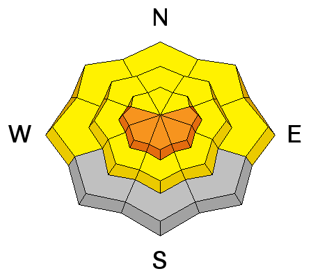
bottom line Dangerous avalanche conditions exist and there's a CONSIDERABLE (level 3) danger at upper elevations in the backcountry. Dangerous triggered storm snow avalanches are possible on slopes steeper than about 30 degrees, especially in drifted terrain above about 8000'. Midday warmth will create dangerous wet avalanche conditions on steep slopes with saturated surface snow
|
 |
special announcement Sign up now for Avalanche Awareness for Snowmobilers with the UAC in Logan, TODAY, February 5th 6:00 to 8:00, and a field session on Saturday the 7th. ***Check out our Practicing Companion Rescue video........HERE
|
 |
current conditions The Tony Grove Snotel reports a couple more inches inches of heavy new snow in the last 24 hours, containing 0.4" of water, with 5" of snow water equivalent since February 2. There's now 75 inches of total snow containing 118% of average water for the date and it's 32 degrees this morning at the 8400' site. The UDOT Hwy 89 Logan Summit weather station reports 27 degrees this morning and greatly diminished light west winds overnight. Heavy new snow and strong winds have created dangerous storm snow avalanche conditions at upper elevations, with a handful of sizable sled triggered slides yesterday in the Tony Grove Area. There is lots of heavy new snow above about 8000' and riding conditions are good, but it feels like you're in California. It's been raining below about 7500', so the new snow at mid-elevations is very wet, melt has taken a serious toll, and any remaining lower elevation snow is saturated throughout.
Poor visibility at upper elevations prevented us from viewing much of anything in the Tony Grove Area yesterday. (2-4-2015)
|
 |
recent activity There were a handful of sled triggered (and perhaps a few natural?) storm slab avalanches in the Tony Grove Area yesterday. These were 1 to 2 feet deep and quite wide, and occurred on slopes facing various directions . One party reported remote triggering a sizable avalanche on a not-so-steep southeast facing slope from a good ways below. Visit our Backcountry Observations Page for more local information and from across the state.
|
| type | aspect/elevation | characteristics |
|---|

|
|
LIKELIHOOD
 LIKELY
UNLIKELY
SIZE
 LARGE
SMALL
TREND
 INCREASING DANGER
SAME
DECREASING DANGER
|
|
description
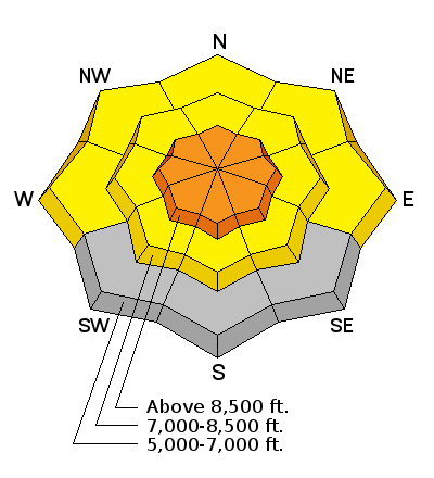
Dangerous triggered avalanches remain possible on upper elevation slopes today, especially in drifted terrain. The rain/snow line is still fairly high, but the heavy new snow is pretty deep and slabby feeling in many areas above about 7500'.
|
| type | aspect/elevation | characteristics |
|---|

|
|
LIKELIHOOD
LIKELY
UNLIKELY
SIZE
LARGE
SMALL
TREND
INCREASING DANGER
SAME
DECREASING DANGER
|
|
description
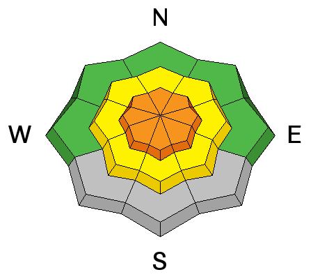
Avoid freshly built ridge-top cornices, which might break further back than you expect and could trigger avalanches on steep slopes below.
|
| type | aspect/elevation | characteristics |
|---|

|
|
LIKELIHOOD
LIKELY
UNLIKELY
SIZE
LARGE
SMALL
TREND
 INCREASING DANGER
SAME
DECREASING DANGER
|
|
description
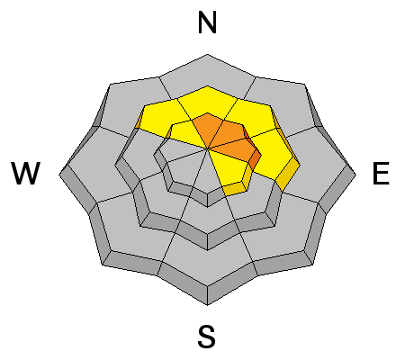
Warmth and perhaps a bit of green-housing will create dangerous wet avalanche conditions today, especially on sunny slopes with heavy and wet new snow. It should be partly cloudy and a bit breezy today, but 8500' temperatures will rise into the mid-forties. The fresh snow is very wet and is likely to want to move on steep slopes when temperatures rise. Wet sluffs and heat induced soft slabs are possible on steep slopes with saturated fresh snow, especially during the warmth of midday.
|
 |
weather It'll be partly sunny and warm today in the mountains, with moderate southwest winds and 8500' high temperatures around 46 degrees. Expect mostly cloudy conditions tonight with a low temperature around 34 degrees and continuing southwest wind. Mostly cloudy conditions are expected tomorrow, with a high of 47 and a continued southwest breeze. A bit more snow up high and rain down low is expected again this weekend, beginning Friday night. Check out our one-stop weather page........HERE
|
| general announcements Special thanks to Buttar's and ArcticCat for hooking us up with the light and powerful M8000. This machine will make our field days more fun, safe, and productive and will significantly boost our outreach and education efforts. RESEARCH PROJECT ON UNDERSTANDING TRAVEL BEHAVIOR IN AVALANCHE TERRAIN NEEDS YOU!! Scientists from the Snow and Avalanche Lab at Montana State University are seeking more participants for their project examining decision making and travel in avalanche terrain. Their project aims to collect GPS location information (from your smartphone) and survey responses from backcountry skiers and riders to better understand what types of terrain are used, and how decisions are made. Their focus is on backcountry skiers and riders of all abilities and experience. More information: If you want to participate, or learn more about their project aims, research questions and approaches, please visit their web page: www.montana.edu/snowscience/tracks or their companion site directed toward snowmobilers at: www.montana.edu/snowscience/sleds You can now receive advisories by email for the Logan Zone. Go here for details. Get your advisory on your iPhone along with great navigation and rescue tools, with our updated, Utah Avalanche Center mobile app Discount lift tickets are now available at Backcountry.com. Thanks to Ski Utah and the Utah Resorts. All proceeds go towards paying for Utah Avalanche Center avalanche and mountain weather advisories. Benefit the Utah Avalanche Center when you shop from Backcountry.com or REI: Click this link for Backcountry.com or this link to REI, shop, and they will donate a percent of your purchase price to the UAC. Both offer free shipping (with some conditions) so this costs you nothing! Benefit the Utah Avalanche Center when you buy or sell on ebay - set the Utah Avalanche Center as a favorite non-profit in your ebay account here and click on ebay gives when you buy or sell. You can choose to have your seller fees donated to the UAC, which doesn't cost you a penny. ***Please submit snow and avalanche observations from your ventures in the backcountry HERE. You can call us at 801-524-5304 or email HERE, or include #utavy in your Instagram or Tweet us @UAClogan. To report avalanche activity in the Logan Area or to contact the local avalanche forecaster call me, Toby, at 435-757-7578. I'll regularly update this advisory on Monday, Wednesday, Friday, and Saturday mornings by about 7:30. This advisory is produced by the U.S.D.A. Forest Service, which is solely responsible for its content. It describes only general avalanche conditions and local variations always exist. |


_1.jpg)